Description:
Europe: Antwerp Joannem Bapt. Vrientium/ Vrients. 1601. Copper engraved minature map by Phillip Galle of Poitou/ Poitiers, Western France, from" Epitome theatri Orteliani praecipuarum orbis regionum delinaetiones. . Editio ultima" Latin text to verso, describing the succeeding map. . Dark impression; overall toning; light foxing/staining to blank margins. The first edition of the"Epitome" in 1577, a reduced format atlas, with minature maps of Abraham Ortelius's "Theatrum" is believed to have been the initiative of the engraver Phillip Galle who asked Peter Heyns to write the text. Ortelius had fled to England in 1576 having taken refuge there from Spanish oppression, and may have been unaware of the plan of his two friends. The pocket atlas was a a commmercial success and was reprinted several times with Galle adding many new maps, and replacing some. Jan. Baptist, Vrients bought the rights and plates of the Epitome from Phillip Galle in 1601, . he published 4 editions using the Galle plates of…
Read More [AMERICAS: Map of Western Hemisphere Titled:] Americae Sive Novi Orbis, Nova Descriptio. by ORTELIUS, A[braham] (1527-1598) - 1571
by ORTELIUS, A[braham] (1527-1598)

[AMERICAS: Map of Western Hemisphere Titled:] Americae Sive Novi Orbis, Nova Descriptio.
by ORTELIUS, A[braham] (1527-1598)
- Used
- very good
Antwerp, 1571. Map. Very Good. No Binding. Antwerp, ca. 1571. Hand coloured copper engraved map ca. 36,5x50,5 cm (14 ½ x 20 in). Map cleaned and sized and with some expert minor repair to lower blank margin, remains of archival mounting tape on verso. Overall still a very good and attractive map. This attractive ornamental map is an impression from the first of three copperplates, without the publisher's address, second state (of three) with the Azores correctly labelled. From one of the third Latin editions, 1571-73. "Ortelius depicts the discoveries of a number of people on this map, but the general shape of the continent is derived from Gerard Mercator's great twenty-one sheet world map of the previous year. The two of them had a close relationship and shared their knowledge openly with each other.., One of the main noticeable features of the map is the bulbous Chilean coastline; this was not corrected until his third plate. A strategically placed cartouche hides a complete lack of knowledge of the southern waters of the Pacific. Once through the Strait of Magellan the voyager's sea route took him on an almost direct course for the East Indies. No sight had been made of a large continent but conventional wisdom had it that there had to be as much land in the southern hemisphere as in the northern. This was not fully dispelled until the second voyage of the remarkable Captain James Cook in 1772-75. The west coast of North America is shown too far west, as was common at the time" (Burden 39). "This is one of the most famous maps of America and one that had enormous influence on the future cartography of the New World. Frans Hogenberg engraved this map and it is primarily based on Gerard Mercator's great multi-sheet world map of 1569. The map features an exaggerated breadth of the North American continent, with a lengthy St. Lawrence River reaching across the continent to nearly meet the fictitious, westward flowing Tiguas Rio. The strategically placed title cartouche hides the unknown South Pacific and therefore most of the conjectural great southern continent, which is shown attached to both New Guinea and Tierra del Fuego" (Old World Auctions); Broecke 9.2; Koeman III, 9000: 31A; Tooley, America S. 320; Wagner 80..
-
Bookseller
Independent bookstores
 (CA)
(CA)
- Book Condition Used - Very Good
- Place of Publication Antwerp
- Date Published 1571

Poitou. " "Pictavia
by Ortelius, Abraham
- Used
- first
- Condition
- Used
- Quantity Available
- 1
- Seller
-
Nafplion, Greece
- Item Price
-
$32.57
Show Details
Item Price
$32.57

Picardia. "
by Ortelius, Abraham
- Used
- first
- Condition
- Used
- Quantity Available
- 1
- Seller
-
Nafplion, Greece
- Item Price
-
$32.57
Show Details
Description:
Europe: Antwerp Joannem Bapt. Vrientium/ Vrients. 1601. Copper engraved minature map by Phillip Galle of Picardy, France, from" Epitome theatri Orteliani praecipuarum orbis regionum delinaetiones. . Editio ultima" Latin text to verso, describing the succeeding map. . Dark impression; overall toning; light foxing/staining to blank margins. The first edition of the"Epitome" in 1577, a reduced format atlas, with minature maps of Abraham Ortelius's "Theatrum" is believed to have been the initiative of the engraver Phillip Galle who asked Peter Heyns to write the text. Ortelius had fled to England in 1576 having taken refuge there from Spanish oppression, and may have been unaware of the plan of his two friends. The pocket atlas was a a commmercial success and was reprinted several times with Galle adding many new maps, and replacing some. Jan. Baptist, Vrients bought the rights and plates of the Epitome from Phillip Galle in 1601, . he published 4 editions using the Galle plates of which this is the…
Read More Item Price
$32.57
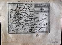
Westfalia. "
by Ortelius, Abraham
- Used
- first
- Condition
- Used
- Quantity Available
- 1
- Seller
-
Nafplion, Greece
- Item Price
-
$32.57
Show Details
Description:
Europe: Antwerp Joannem Bapt. Vrientium/ Vrients. 1601. Copper engraved minature map by Phillip Galle of Westphalia, Germany, from" Epitome theatri Orteliani praecipuarum orbis regionum delinaetiones. . Editio ultima" Latin text to verso, describing the succeeding map. . Dark impression, overall toning, light foxing to blank margins. Light dampstaining to blank margins. The first edition of the"Epitome" in 1577, a reduced format atlas, with minature maps of Abraham Ortelius's "Theatrum" is believed to have been the initiative of the engraver Phillip Galle who asked Peter Heyns to write the text. Ortelius had fled to England in 1576 having taken refuge there from Spanish oppression, and may have been unaware of the plan of his two friends. The pocket atlas was a a commmercial success and was reprinted several times with Galle adding many new maps, and replacing some. Jan. Baptist, Vrients bought the rights and plates of the Epitome from Phillip Galle in 1601, . he published 4 editions using the…
Read More Item Price
$32.57

Blesiense Territorium. "
by Ortelius, Abraham
- Used
- first
- Condition
- Used
- Quantity Available
- 1
- Seller
-
Nafplion, Greece
- Item Price
-
$32.57
Show Details
Description:
Europe: Antwerp Joannem Bapt. Vrientium/ Vrients. 1601. Copper engraved minature map by Phillip Galle of Blois, France, from" Epitome theatri Orteliani praecipuarum orbis regionum delinaetiones. . Editio ultima" Latin text to verso, describing the succeeding map. . Dark impression; overall toning; light foxing/staining to blank margins. The first edition of the"Epitome" in 1577, a reduced format atlas, with minature maps of Abraham Ortelius's "Theatrum" is believed to have been the initiative of the engraver Phillip Galle who asked Peter Heyns to write the text. Ortelius had fled to England in 1576 having taken refuge there from Spanish oppression, and may have been unaware of the plan of his two friends. The pocket atlas was a a commmercial success and was reprinted several times with Galle adding many new maps, and replacing some. Jan. Baptist, Vrients bought the rights and plates of the Epitome from Phillip Galle in 1601, . he published 4 editions using the Galle plates of which this is the…
Read More Item Price
$32.57

Turonensis Ducatus. "
by Ortelius, Abraham
- Used
- first
- Condition
- Used
- Quantity Available
- 1
- Seller
-
Nafplion, Greece
- Item Price
-
$32.57
Show Details
Description:
Europe: Antwerp Joannem Bapt. Vrientium/ Vrients. 1601. Copper engraved minature map by Phillip Galle of Touraine, France, from" Epitome theatri Orteliani praecipuarum orbis regionum delinaetiones. . Editio ultima" Latin text to verso, describing the succeeding map. . Dark impression; overall toning; light foxing/staining to blank margins. The first edition of the"Epitome" in 1577, a reduced format atlas, with minature maps of Abraham Ortelius's "Theatrum" is believed to have been the initiative of the engraver Phillip Galle who asked Peter Heyns to write the text. Ortelius had fled to England in 1576 having taken refuge there from Spanish oppression, and may have been unaware of the plan of his two friends. The pocket atlas was a a commmercial success and was reprinted several times with Galle adding many new maps, and replacing some. Jan. Baptist, Vrients bought the rights and plates of the Epitome from Phillip Galle in 1601, . he published 4 editions using the Galle plates of which this is the…
Read More Item Price
$32.57

Delphinatus. " "Auaicus Principatus
by Ortelius, Abraham
- Used
- first
- Condition
- Used
- Quantity Available
- 1
- Seller
-
Nafplion, Greece
- Item Price
-
$32.57
Show Details
Description:
Europe: Antwerp Joannem Bapt. Vrientium/ Vrients. 1601. Copper engraved minature map by Phillip Galle of Duphiné, France, from" Epitome theatri Orteliani praecipuarum orbis regionum delinaetiones. . Editio ultima" Latin text to verso, describing the succeeding map. . Dark impression; overall toning; light foxing/staining to blank margins. The first edition of the"Epitome" in 1577, a reduced format atlas, with minature maps of Abraham Ortelius's "Theatrum" is believed to have been the initiative of the engraver Phillip Galle who asked Peter Heyns to write the text. Ortelius had fled to England in 1576 having taken refuge there from Spanish oppression, and may have been unaware of the plan of his two friends. The pocket atlas was a a commmercial success and was reprinted several times with Galle adding many new maps, and replacing some. Jan. Baptist, Vrients bought the rights and plates of the Epitome from Phillip Galle in 1601, . he published 4 editions using the Galle plates of which this is the…
Read More Item Price
$32.57

Veromandui. "
by Ortelius, Abraham
- Used
- first
- Condition
- Used
- Quantity Available
- 1
- Seller
-
Nafplion, Greece
- Item Price
-
$32.57
Show Details
Description:
Europe: Antwerp Joannem Bapt. Vrientium/ Vrients. 1601. Copper engraved minature map by Phillip Galle of the area around St. Quentin & Pérrone. known as Vermandois, France, from" Epitome theatri Orteliani praecipuarum orbis regionum delinaetiones. . Editio ultima" Latin text to verso, describing the succeeding map. . Dark impression; overall toning; light foxing/staining to blank margins; printed crooked on the page. heading shaved, and upper margin very short2-6mm. The first edition of the"Epitome" in 1577, a reduced format atlas, with minature maps of Abraham Ortelius's "Theatrum" is believed to have been the initiative of the engraver Phillip Galle who asked Peter Heyns to write the text. Ortelius had fled to England in 1576 having taken refuge there from Spanish oppression, and may have been unaware of the plan of his two friends. The pocket atlas was a a commmercial success and was reprinted several times with Galle adding many new maps, and replacing some. Jan. Baptist, Vrients bought the…
Read More Item Price
$32.57

Aniou. " "Andegavensis Ducatus
by Ortelius, Abraham
- Used
- first
- Condition
- Used
- Quantity Available
- 1
- Seller
-
Nafplion, Greece
- Item Price
-
$32.57
Show Details
Description:
Europe: Antwerp Joannem Bapt. Vrientium/ Vrients. 1601. Copper engraved minature map by Phillip Galle of Anjou, France, from" Epitome theatri Orteliani praecipuarum orbis regionum delinaetiones. . Editio ultima" Latin text to verso, describing the succeeding map. . Dark impression, overall toning, light foxing to blank margins; one darker spot to lower blank margin The first edition of the"Epitome" in 1577, a reduced format atlas, with minature maps of Abraham Ortelius's "Theatrum" is believed to have been the initiative of the engraver Phillip Galle who asked Peter Heyns to write the text. Ortelius had fled to England in 1576 having taken refuge there from Spanish oppression, and may have been unaware of the plan of his two friends. The pocket atlas was a a commmercial success and was reprinted several times with Galle adding many new maps, and replacing some. Jan. Baptist, Vrients bought the rights and plates of the Epitome from Phillip Galle in 1601, . he published 4 editions using the Galle…
Read More Item Price
$32.57

Caletum et Bononia. "
by Ortelius, Abraham
- Used
- first
- Condition
- Used
- Quantity Available
- 1
- Seller
-
Nafplion, Greece
- Item Price
-
$32.57
Show Details
Description:
Europe: Antwerp Joannem Bapt. Vrientium/ Vrients. 1601. Copper engraved minature map by Phillip Galle of the Pas-de Calais, France, from" Epitome theatri Orteliani praecipuarum orbis regionum delinaetiones. . Editio ultima" Latin text to verso, describing the succeeding map. . Dark impression; overall toning; light foxing/staining to blank margins. The first edition of the"Epitome" in 1577, a reduced format atlas, with minature maps of Abraham Ortelius's "Theatrum" is believed to have been the initiative of the engraver Phillip Galle who asked Peter Heyns to write the text. Ortelius had fled to England in 1576 having taken refuge there from Spanish oppression, and may have been unaware of the plan of his two friends. The pocket atlas was a a commmercial success and was reprinted several times with Galle adding many new maps, and replacing some. Jan. Baptist, Vrients bought the rights and plates of the Epitome from Phillip Galle in 1601, . he published 4 editions using the Galle plates of which this…
Read More Item Price
$32.57

Campania. "
by Ortelius, Abraham
- Used
- first
- Condition
- Used
- Quantity Available
- 1
- Seller
-
Nafplion, Greece
- Item Price
-
$32.57
Show Details
Description:
Europe: Antwerp Joannem Bapt. Vrientium/ Vrients. 1601. Copper engraved minature map by Phillip Galle of Champagne, France, from" Epitome theatri Orteliani praecipuarum orbis regionum delinaetiones. . Editio ultima" Latin text to verso, describing the succeeding map. . Dark impression; overall toning; light foxing/staining to blank margins. The first edition of the"Epitome" in 1577, a reduced format atlas, with minature maps of Abraham Ortelius's "Theatrum" is believed to have been the initiative of the engraver Phillip Galle who asked Peter Heyns to write the text. Ortelius had fled to England in 1576 having taken refuge there from Spanish oppression, and may have been unaware of the plan of his two friends. The pocket atlas was a a commmercial success and was reprinted several times with Galle adding many new maps, and replacing some. Jan. Baptist, Vrients bought the rights and plates of the Epitome from Phillip Galle in 1601, . he published 4 editions using the Galle plates of which this is the…
Read More Item Price
$32.57