Click for full-size.

ARKANSAS
by MITCHELL, Augustus (cartog.)
- Used
- near fine
- Hardcover
- Condition
- Near Fine
- Seller
-
COLUMBIA, Missouri, United States
Payment Methods Accepted
About This Item
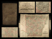
1888 HUGE Colton MAP of ARKANSAS Geography Atlas Little Rock 28x34in Mitchell
Colton maps are often considered the very best of 19th-century maps. Known for their accuracy and attention to detail, Colton maps have maintained their desirability even into the 21st-century. Cartographers such as Augustus Mitchell would use Colton to publish their maps.
This huge folding map of the state of Arkansas was published in New York, bound in a small pocket-size tome.
Item number: #16722
Price: $599
MITCHELL, Augustus (cartog.)
ARKANSAS
New York : G.W. & C.B. Colton & Co, [1888].
Details:
· Binding: Hardcover; secure
o Cloth
· Map size: ~28in X 34.75in (71.5cm x 88cm)
· Tome size: ~6.25in X 4in (15.5cm x 10cm)
Our Guarantee:
Very Fast. Very Safe. Free Shipping Worldwide.
Customer satisfaction is our priority! Notify us with 7 days of receiving, and we will offer a full refund without reservation!
16722
Photos available upon request.
Reviews
(Log in or Create an Account first!)
Details
- Bookseller
- Schilb Antiquarian Rare Books
 (US)
(US)
- Bookseller's Inventory #
- 16722
- Title
- ARKANSAS
- Author
- MITCHELL, Augustus (cartog.)
- Format/Binding
- Hardcover; secure
- Book Condition
- Used - Near Fine
- Quantity Available
- 1
- Binding
- Hardcover
- Publisher
- G.W. & C.B. Colton & Co
- Place of Publication
- New York
- Date Published
- 1888
- Weight
- 0.00 lbs
- Keywords
- 1888 HUGE Colton MAP of ARKANSAS Geography Atlas Little Rock 28x34in Mitchellrare, antique, old, first edition, 1st state, provenance, signed, inscribed, dust jacket, vellum, manuscript, engravings, illustrations, leather, plates, maps, antiquarian
Terms of Sale
Schilb Antiquarian Rare Books
30 day return guarantee, with full refund including original shipping costs for up to 30 days after delivery if an item arrives misdescribed or damaged.
About the Seller
Schilb Antiquarian Rare Books
Biblio member since 2018
COLUMBIA, Missouri
About Schilb Antiquarian Rare Books
We live & breathe rare books! This year we are celebrating over a decade of business with over 10,000 positive transactions all over the globe! We remain at your service and look forward to earning your business.
Glossary
Some terminology that may be used in this description includes:
This Book’s Categories

Collecting BiblioMysteries
Want to get meta? Bibliomysteries are mystery stories which deal in some significant way with books and the world associated with books. Browse this fascinating subgenre of mystery novels.

Collecting Signed Books
Read through our tips, hints, and information on collecting books signed or inscribed by the author or illustrator.