Description:
London: Printed by T.Cotes, for Michael Sparkes and Samuel Cartwright, [1635].. Original engraved map of Argau / Switzerland (map dimensions 19.2 x 14 cm, overall dimensions 29.5 x 18.5 cm) with later hand-colouring. Covering the area around the Lake Lucerne, Lake Zurich and Lake Thun. With English text to verso. A bit tanned and with a few small nicks to margins, generally very good. From "Historia Mundi or Mercator's Atlas ..."
Asia ex magna orbis terre descriptione Gerardi Marcatoris desumpta studio et industria G.M. Iunioris. by MERCATOR, Gerard (1512-1594) - 1595
by MERCATOR, Gerard (1512-1594)
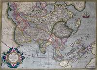
Asia ex magna orbis terre descriptione Gerardi Marcatoris desumpta studio et industria G.M. Iunioris.
by MERCATOR, Gerard (1512-1594)
- Used
Duisburg, 1595., 1595. A SUPERB MAP OF ASIA FROM MERCATOR'S FUNDAMENTAL ATLAS DEMONSTRATING EXCEPTIONAL CONDITION AND QUALITY OF ORIGINAL COLOR. Copper-plate engravings with original hand color, from Mercator's Atlantis Pars Altera atlas of 1595. For nearly sixty years, during the most important and exciting period in the story of modern mapmaking, Gerard Mercator was the supreme cartographer, his name, second only to Ptolemy, synonymous with forms of map projection still in use today. Although not the inventor of this type of projection, he was the first to apply it to navigational charts in such a form that compass bearings could be plotted on charts in straight lines, thereby providing sailors with a solution to an age-old problem of navigation at sea. His influence transformed land surveying and his research and calculations lead him to break away from Ptolemy's conception of the size and outline of the continents. This drastically reduced the longitudinal length of Europe and Asia and altered the shape of the Old World as visualized in the early 16th century. Unlike the work of Abraham Ortelius, a contemporary (and equally celebrated) cartographer, Mercator's maps are original. Ortelius did what most of the atlas-makers of our time are engaged in: the reduction and generalization of already existing maps. Gerard Mercator, with his sense that scientific work should be original and new, checked the current knowledge of the earth's topography against its fundamental sources and drew maps in an original manner. After his death in 1594 it was left to Mercator's son Rumold to publish the last of three parts that formed his famous atlas, the Atlantis Pars Altera. The atlas was finished with a number of maps engraved by various descendants of Gerard, such as the superb map of the Americas executed by Michael Mercator, his grandson, which is the only known work by this clearly gifted mapmaker. This spectacular map represents a remarkable example of Mercator's Asia, with the highest quality in engraving, color, ornament, and geographical sophistication.. Map.
-
Bookseller
Arader Galleries
 (US)
(US)
- Book Condition Used
- Place of Publication Duisburg, 1595.
- Date Published 1595
- Keywords Maps, Cartography, Navigational Charts, Asia

Argow (Aargau).
by MERCATOR, Gerard & HONDIUS, Jodocus
- Used
- Condition
- Used
- Quantity Available
- 1
- Seller
-
London, London, United Kingdom
- Item Price
-
$31.67
Show Details
Item Price
$31.67

The World of Gerard Mercator; The Mapmaker Who Revolutionized Geography
by Taylor, Andrew (Biography of Gerard Mercator.)
- Used
- Hardcover
- Condition
- Used
- Binding
- Hardcover
- ISBN 10 / ISBN 13
- 9780802713773 / 0802713777
- Quantity Available
- 1
- Seller
-
Winnipeg, Manitoba, Canada
- Item Price
-
$26.25
Show Details
Description:
New York: Walker & Company [0-8027-1377-7] 2004. (Hardcover) 291pp. Near fine in fine dust jacket. Illustrations, maps, notes, bibliography, index. "The story of discovery and mapmaking is one of pushing back shadows, and no one in the last two thousand years achieved as much as Gerard Mercator in extending the boundaries of the known world. His life spanned most of the turbulent, extraordinary sixteenth century". Biography of Gerard Mercator. Time Period 16th Century. (Travel, Cartographers, Cartography, Geography, Mapmaking, Navigation, Travel).
Item Price
$26.25

THE WORLD OF GERARD MERCATOR: The Mapmaker Who Revolutionised Geography
by Mercator, Gerard; Tayor, Andrew
- Used
- first
- Condition
- Used
- Quantity Available
- 1
- Seller
-
Melbourne, Victoria, Australia
- Item Price
-
$29.76
Show Details
Description:
London: HarperCollinsPublishers, 2004. Pp. xii+292(last blank), pictorial double title page, text illustrations, notes, bibliography, index; demy 8vo; green boards, spine lettered in gilt; dust wrapper, slightly foxed; book label of David Levine, Sydney, on upper pastedown, edges of leaves slightly foxed; HarperCollinsPublishers, London, 2004. First edition..
Item Price
$29.76

Gerard Mercator en de geografie in de zuidelijke Nederlanden (16de eeuw) / Gerard Mercator et la geographie dans les Pays-Bas meridionaux (16e siècle)
by Mercator, Gerard
- Used
- Paperback
- Condition
- Used
- Binding
- Paperback
- Quantity Available
- 1
- Seller
-
H.I. Ambacht, Netherlands
- Item Price
-
$24.97
Show Details
Description:
Antwerpen, Stad 1994. 175 p. Paperback
Item Price
$24.97

La Partie Septentrionale du Languedoc. "
by Mercator, Gerard
- Used
- Condition
- Used
- Quantity Available
- 1
- Seller
-
Nafplion, Greece
- Item Price
-
$43.42
Show Details
Description:
Europe: Amsterdam, Johannis Cloppenburgji. 1632. Copper engraved map of Languedoc, France. from" Gerardi Mercatoris, Atlas sive Cosmographicae Meditationes de Fabrica mundi et fabricati figura, "Latin text to verso. Fair impression, slightly weak in places; light damp stain to upper margin. The "Atlas Minor" of Gerhard Mercator appears in various formats, the first published by Jodicus Hondius in 1607 with plates he most likely engraved himself. Thereafter there appeared a number of editions. In 1628 Johannes Janssonius published a new series of editions, the plates engraved by Petrus Kaerius and Abraham Goos. Both of these were small format atlases in the tradition of that published by Langenes. In 1630 Johannes Cloppenburg published a French edition in a somewhat larger size, followed by this Latin edition in 1632. The plates were in the main engraved by Petrus Kaerius. Cloppenburg published the Altas at his own expense "sumptibus"as the imprint states. There was one more edition in 1636…
Read More Item Price
$43.42

Champagne, comitatus Campania. "
by Mercator, Gerard
- Used
- Condition
- Used
- Quantity Available
- 1
- Seller
-
Nafplion, Greece
- Item Price
-
$43.42
Show Details
Description:
Europe: Amsterdam, Johannis Cloppenburgji. 1632. Copper engraved map of Champagne, France, from" Gerardi Mercatoris, Atlas sive Cosmographicae Meditationes de Fabrica mundi et fabricati figura, "Latin text to verso. Dark impression; light damp stain to upper margin. Heading "Campania. " just entering plate mark. The "Atlas Minor" of Gerhard Mercator appears in various formats, the first published by Jodicus Hondius in 1607 with plates he most likely engraved himself. Thereafter there appeared a number of editions. In 1628 Johannes Janssonius published a new series of editions, the plates engraved by Petrus Kaerius and Abraham Goos. Both of these were small format atlases in the tradition of that published by Langenes. In 1630 Johannes Cloppenburg published a French edition in a somewhat larger size, followed by this Latin edition in 1632. The plates were in the main engraved by Petrus Kaerius. Cloppenburg published the Altas at his own expense "sumptibus"as the imprint states. There was one…
Read More Item Price
$43.42

Bolonia & Guines Comitatus. "
by Mercator, Gerard
- Used
- Condition
- Used
- Quantity Available
- 1
- Seller
-
Nafplion, Greece
- Item Price
-
$43.42
Show Details
Description:
Europe: Amsterdam, Johannis Cloppenburgji. 1632. Copper engraved map of Boulogne, France, from" Gerardi Mercatoris, Atlas sive Cosmographicae Meditationes de Fabrica mundi et fabricati figura, "Latin text to verso. Dark impression; damp stain to upper margin. The "Atlas Minor" of Gerhard Mercator appears in various formats, the first published by Jodicus Hondius in 1607 with plates he most likely engraved himself. Thereafter there appeared a number of editions. In 1628 Johannes Janssonius published a new series of editions, the plates engraved by Petrus Kaerius and Abraham Goos. Both of these were small format atlases in the tradition of that published by Langenes. In 1630 Johannes Cloppenburg published a French edition in a somewhat larger size, followed by this Latin edition in 1632. The plates were in the main engraved by Petrus Kaerius. Cloppenburg published the Altas at his own expense "sumptibus"as the imprint states. There was one more edition in 1636 with French text. Due to thier…
Read More Item Price
$43.42

France, Picardie, Champaigne cum regionibus adiacentibus. "
by Mercator, Gerard
- Used
- Condition
- Used
- Quantity Available
- 1
- Seller
-
Nafplion, Greece
- Item Price
-
$43.42
Show Details
Description:
Europe: Amsterdam, Johannis Cloppenburgji. 1632. Copper engraved map of Picardy & Champagne regions of France, from" Gerardi Mercatoris, Atlas sive Cosmographicae Meditationes de Fabrica mundi et fabricati figura, "Latin text to verso. Dark impression; damp stain to upper margin. The "Atlas Minor" of Gerhard Mercator appears in various formats, the first published by Jodicus Hondius in 1607 with plates he most likely engraved himself. Thereafter there appeared a number of editions. In 1628 Johannes Janssonius published a new series of editions, the plates engraved by Petrus Kaerius and Abraham Goos. Both of these were small format atlases in the tradition of that published by Langenes. In 1630 Johannes Cloppenburg published a French edition in a somewhat larger size, followed by this Latin edition in 1632. The plates were in the main engraved by Petrus Kaerius. Cloppenburg published the Altas at his own expense "sumptibus"as the imprint states. There was one more edition in 1636 with French…
Read More Item Price
$43.42

Perchensis Comitatus, La Perche Comte. " "Comitatus Berticensis
by Mercator, Gerard
- Used
- Condition
- Used
- Quantity Available
- 1
- Seller
-
Nafplion, Greece
- Item Price
-
$43.42
Show Details
Description:
Europe: Amsterdam, Johannis Cloppenburgji. 1632. Copper engraved map of Perche in Northern France, home of the famous Percheron draft horses, from" Gerardi Mercatoris, Atlas sive Cosmographicae Meditationes de Fabrica mundi et fabricati figura, "Latin text to verso. Dark impression; damp stain to upper margin. The "Atlas Minor" of Gerhard Mercator appears in various formats, the first published by Jodicus Hondius in 1607 with plates he most likely engraved himself. Thereafter there appeared a number of editions. In 1628 Johannes Janssonius published a new series of editions, the plates engraved by Petrus Kaerius and Abraham Goos. Both of these were small format atlases in the tradition of that published by Langenes. In 1630 Johannes Cloppenburg published a French edition in a somewhat larger size, followed by this Latin edition in 1632. The plates were in the main engraved by Petrus Kaerius. Cloppenburg published the Altas at his own expense "sumptibus"as the imprint states. There was one…
Read More Item Price
$43.42

Touraine, Turonensis Ducatus. "
by Mercator, Gerard
- Used
- Condition
- Used
- Quantity Available
- 1
- Seller
-
Nafplion, Greece
- Item Price
-
$43.42
Show Details
Description:
Europe: Amsterdam, Johannis Cloppenburgji. 1632. Copper engraved map of Touraine, France. from" Gerardi Mercatoris, Atlas sive Cosmographicae Meditationes de Fabrica mundi et fabricati figura, "Latin text to verso. Generally good impression, slightly weaker in the lower third; damp stain to upper margin; crease to lower right corner. The "Atlas Minor" of Gerhard Mercator appears in various formats, the first published by Jodicus Hondius in 1607 with plates he most likely engraved himself. Thereafter there appeared a number of editions. In 1628 Johannes Janssonius published a new series of editions, the plates engraved by Petrus Kaerius and Abraham Goos. Both of these were small format atlases in the tradition of that published by Langenes. In 1630 Johannes Cloppenburg published a French edition in a somewhat larger size, followed by this Latin edition in 1632. The plates were in the main engraved by Petrus Kaerius. Cloppenburg published the Altas at his own expense "sumptibus"as the imprint…
Read More Item Price
$43.42