Description:
[London: J. F. W. Des Barres, 1781. Engraved with aquatint, on single double-page sheet watermarked "J. Bates." Excellent condition with minor repairs along centerfold. Detailed depiction of the mouth of the Miramachi River in New Brunswick and Miramachi Bay in the Gulf of St. Larwence. Des Barres, of Swiss-Huguenot extraction, studied under the great mathematician Daniel Bernoulli at the University of Basel, before continuing on to the Royal Military College at Woolwich. Upon the outbreak of hostilities with France in 1756, he joined the British Royal American Regiment as a military engineer. He came to the attention of General James Wolfe, who appointed him to join his personal detail. During this period he also worked with the future legendary explorer James Cook on a monumental chart of the St. Lawrence River. From 1762, Des Barres was enlisted to survey the coastlines of Nova Scotia, Newfoundland, and the Gulf of St. Lawrence, while his colleague, Samuel Holland charted the New England coast.…
Read More [The Atlantic Neptune Published for the Use of the Royal Navy of Great Britain ... Vol. II] ... The Sea Coast of Nova Scotia; exhibiting the diversities of the coast and face of the country near it: the banks, rocks, shoals, soundings &c. together with remarks and directions of the conveniency of navigation and pilotage. Surveyed by Order of the Right Honourable the Lords Commissioners of the Admiralty by DES BARRES, Joseph F. Wallet (1721?-1824) - 1781
by DES BARRES, Joseph F. Wallet (1721?-1824)
![[The Atlantic Neptune Published for the Use of the Royal Navy of Great Britain ... Vol. II] ... The Sea Coast of Nova Scotia; exhibiting the diversities of the coast and face of the country near it: the banks, rocks, shoals, soundings &c. together with remarks and directions of the conveniency of navigation and pilotage. Surveyed by Order of the Right Honourable the Lords Commissioners of the Admiralty by DES BARRES, Joseph F. Wallet (1721?-1824) - 1781](https://d3525k1ryd2155.cloudfront.net/h/202/510/1048510202.1.m.jpg)
[The Atlantic Neptune Published for the Use of the Royal Navy of Great Britain ... Vol. II] ... The Sea Coast of Nova Scotia; exhibiting the diversities of the coast and face of the country near it: the banks, rocks, shoals, soundings &c. together with remarks and directions of the conveniency of navigation and pilotage. Surveyed by Order of the Right Honourable the Lords Commissioners of the Admiralty
by DES BARRES, Joseph F. Wallet (1721?-1824)
- Used
[London: The Admiralty, 1781. Folio. (25 x 16 1/2 inches). Engraved, printed on laid paper and mounted on guards throughout. Engraved title, engraved and hand-coloured references sheet, 4 text leaves (Contents of the Charts [folding], Tables [letterpress and folding], Directions for Canso Harbour, Remarks on the Isle of Sable]. 33 engraved and aquatint charts and views, most hand coloured. Expertly bound to style in half russia and period marbled paper covered boards, spine with raised bands in seven compartments, red and black morocco lettering pieces The eastern Nova Scotia section of Des Barres' masterpiece, The Atlantic Neptune: here with many of the rare views seldom found in copies, and with period hand-colouring throughout. One of the greatest achievements of 18th century cartography, Des Barres charted the Nova Scotia coastline with a degree of accuracy not seem before and with a level of artistry not seen since. A major cartographic landmark and the best depiction of the North American coast during the American Revolution. Joseph Des Barres was born in Switzerland in 1721 and educated in Basel before emigrating to England and entering the Royal Military College where he learned engineering and the art of surveying. In 1756, Des Barres was commissioned a Lieutenant in the Royal American Regiment and despatched to North America. He served in America during the Seven Years War under Colonel Bouquet, Lord Howe and General Amherst, and participated in the Quebec campaign as General Wolfe's engineer. The end of the French and Indian War opened much of Canada to British trade; surveys of the region were immediately ordered, as the waterways were deemed of vital economic importance to the inland fur trade. Des Barres, having proven himself during the war, was selected to survey the coasts of Nova Scotia, at the outset, and eventually much of the coastline of the American colonies. The work was difficult and at times dangerous, but Des Barres persisted at the task and repeatedly rechecked his surveys to ensure their accuracy. Returning to England in 1774, and upon the urging of Lord Howe, publication of Des Barres surveys was begun on a scale not previously attempted in Great Britain. Beginning with his surveys of Nova Scotia, Des Barres over a ten year period would publish his Atlantic Neptune, comprised of maps and views from his own surveys and those of other military officers (including Major Samuel Holland, for example), depicting the entire North American coast, from Canada to the Gulf of Mexico. It would prove to be "the most splendid collection of charts, plans and views ever published" (Rich). The publication history of Des Barres's great work is extraordinarily complex. The atlas was published in four sections: Nova Scotia, New England, the Gulf of St. Lawrence and the coast from New York to the Gulf of Mexico. The atlas was published in two forms: in large flat volumes with the maps largely unfolded (as here), or as tall volumes with folded maps and plates (the latter being a form more conducive to shipboard use). The four sections were offered for sale both together, and separately. The charts and views within the volumes were sold individually as well. Copies of the Atlantic Neptune are generally found with title pages dated 1777, 1778, 1779, 1780 or 1781. However, these do not necessarily comprise specific editions, due to their bespoke nature and the fact that the contents evolved considerably over the course of publication. Des Barres continually updated his charts and views, yielding an incredible number of variants and states. Perhaps the greatest variations are seen, however, within the views. The views, were not included in all copies of the Neptune, with many extant examples merely a collection of the charts. The views are found as line engravings with elaborate hand colouring, as uncoloured aquatints, or as aquatints printed in sepia. For many of the views, Des Barres reworked the plates over the publication history, adding shading, ships, or in some cases hammering out the copperplates and beginning the engraving entirely anew. It is believed that copies of the Atlantic Neptune were compiled on a bespoke basis, or based on the sheets available at the time of purchase; i.e. that as the charts and views were for sale individually, that the stock of sheets with which to make up copies of the Neptune changed frequently. Furthermore, as Des Barres was continuously re-working plates, some charts and views were not available at all times. During the course of publication, some views were dropped entirely, some views were replaced by others and new charts and views were inserted into copies whenever they were ready regardless of "edition." Copies of the Neptune with similarly dated title pages, therefore, are infrequently comprised of identical contents and no copy of the Atlantic Neptune can possibly be comprised of all known views (unless, of course, views were added as extra-illustrations at a later date). The present second half of Nova Scotia section (i.e. the eastern half, including both the south east and north east coasts, as well as the Gut of Canso and Sable island) includes 33 charts and views, most with period hand colouring. The charts are, without exception, beautifully presented and of an accuracy that was unheard of in the eighteenth century. This section also includes views and coastal profiles. Des Barres wished to give accurate depictions of the towns, harbours and views to be found all along the east coast of North America and he personally executed most of the drawings on which the original engravings were based. The present volume contains some of the most lavish of Des Barres's aquatint engravings. Many of the most interesting points of the entire coast are covered. Of particular interest are the fine views of Sable Island, whose shallow shifting shoals of sand were a graveyard for unwary ships. Des Barres spent two seasons here, and his aquatints show the island, his camps and his team at work. The present collection comprises: 1) The South East Coast of Nova Scotia. On four sheets, joined. Stevens 44f. 2) Halifax Harbour. On three sheets, joined. Stevens 45i. 3) [Plan of Halifax]. Double-page sheet. Stevens 46e. Minor restoration to losses at corners. 4) [Six views of Halifax Harbour]. Double-page sheet, lower view hand coloured. Stevens 48e. 5) [Chart of Egmont Harbour, with inset views]. Double-page sheet, hand coloured. Stevens 49g. 6) [Chart of Keppell Harbour and Knowles Harbour, with inset views]. Two double page sheets, hand coloured. Stevens 50e. 7) [Six views of Cape Egmont, Egmont Harbour, etc.] Double-page sheet, two views hand coloured. Stevens 51e. 8) [Chart of Spry Harbour, Port Pallisser, etc.]. Two double page sheets, hand coloured. Stevens 52g. 9) [Chart of White Islands Harbour, Port Stephens, etc.]. Two double page sheets, hand coloured. Stevens 53e. 10) [Chart of Sandwich Bay]. Two double page sheets, hand coloured. Stevens 54g. 11) [Chart of Torbay, with inset view of Berry Head]. Double-page sheet, hand coloured. Stevens 55f. 12) [Chart of White Haven, with inset view] Double-page sheet, hand coloured. Stevens 56g. 13) [Chart of Canso Harbour with inset view of Port George]. Double-page sheet, hand coloured. Stevens 57g. 14) [Chart of Crow Harbour]. Single page sheet, hand coloured. Stevens 58f. 15) [Chart of St. Peters Bay, with inset view of Cape Round]. Double-page sheet, hand coloured. Stevens 59f. 16) [Chart of Milford Haven, with inset view]. Double-page sheet, hand coloured. Stevens 60f. 17) [Chart of Conway Harbour & Port Aylesbury]. Double-page sheet, hand coloured. Stevens 62g. 18) [Eight views, From White Islands to St. Mary's River, Entrance of Milford Harbour, etc.] Two double-page sheets, hand coloured. Stevens 61e. 19) [Chart of Lennox Passage, Richmond Isles, &c.] Three double-page sheets, hand coloured. Stevens 63d. 20) [Chart of the North East Coast of Nova Scotia] Three double-page sheets, hand coloured. Stevens 67e. 21) [Chart of the Gut of Canso]. Three double-page sheets, hand coloured. Stevens 66g 22) [Chart of Port Hood]. Double-page sheet, hand coloured. Stevens 69i. 23) Entrance of Port Hood. Double-page view printed in sepia. Stevens 70A. Unrecorded scratch proof. 24) A View of the Plaister Cliffs on the West Shore of George's Bay. Double-page view printed in sepia. Stevens 70Ba 25) [Chart of Frederick Bay, Pictou Harbour, etc.]. Four double-page sheets, hand coloured. Stevens 71g. 26) [Chart of the Coast from Bay Verte to Bugtush]. Double-page sheet, hand coloured. Stevens 68e. 27) [Chart of Port Shediack and Cocagne]. Double-page sheet, hand coloured. Stevens 72h. 28) The Entrance of Louisbourg Harbour on the Island of Cape Breton. Double-page sheet, printed in sepia. Stevens 65c. 29) [Chart of the Isle of Sable]. Two double-page sheets, hand coloured. Stevens 73h. 30) [Five views of the Isle of Sable]. Double-page sheet, hand coloured. Stevens 74f. 31) The Isle of Sable. Four double-page sheets, hand coloured. Stevens 76d. 32) [Seven views or elevations of the Isle of Sable]. Two double-page sheets, hand coloured. Stevens 75c. 33) A View from the Camp at the East End of the Naked Sand Hills, on the South East Shore of the Isle of Sable. Double page sheet, printed in sepia. Stevens 77b. The copper plates for the charts and views would continue to be used following the American Revolution, with some copies of the Atlantic Neptune found with charts on wove paper from the 19th century. In 1784, Des Barres, who had large land holdings in the Maritimes, became Lieutenant Governor of Cape Breton and in 1804, the Lieutenant Governor of Prince Edward Island. He died in Halifax in 1824 at the age of 103. John Carter Brown Library Charting the East Coast of North America, The Atlantic Neptune (Providence: 1972); Robert Lingel 'The Atlantic Neptune' in the Bulletin of the New York Public Library , July 1936, pp.571-603; Augustus P. Loring 'The Atlantic Neptune' in American Maritime Prints (New Bedford: 1985); NMM III, p. 380; Phillips Atlases 1198-1205, 3654-3659; Streeter Sale 706.
-
Bookseller
Donald Heald Rare Books
 (US)
(US)
- Format/Binding Folio
- Book Condition Used
- Quantity Available 1
- Publisher The Admiralty
- Place of Publication [London
- Date Published 1781
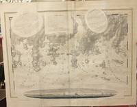
![[Miramichi Bay]](https://d3525k1ryd2155.cloudfront.net/h/570/933/1237933570.1.m.jpg)
[Miramichi Bay]
by DES BARRES, Joseph F. Wallet (1721-1824)
- Used
- Condition
- Used
- Quantity Available
- 1
- Seller
-
New York, New York, United States
- Item Price
-
$2,000.00
Show Details
Item Price
$2,000.00
Spry Harbour; Port Pallisser; Port North; Port Parker; Beaver Harbour; Fleming River.
by Des Barres, Joseph F.W. (Frederick Wallet) 1722-1824
- Used
- Condition
- Used - Very Good, wide margins
- Quantity Available
- 1
- Seller
-
Toronto, Ontario, Canada
- Item Price
-
$2,000.00
Show Details
Description:
London, 1779. Very Good, wide margins. Notes: With oval shaped Inset View showing Cape Spry N. NE…, Beaver Isles…, Westermost Ledge of Pegasus Wing East...The Atlantic Neptune, published for the Royal Navy of Great Britain in London, [1774-1781]. It included a comprehensive survey of the coasts of Nova Scotia, the coasts and harbors of the Gulf and River of St. Lawrence and the Atlantic coast of North America including New York to Mexico, and New England., Size : 723x1035 (mm), 28.46x40.75 (Inches), Coloring: Original Outline Coloring, Category: Maps Canada East Nova Scotia;
Item Price
$2,000.00

A View of Quebec from the South East
by DES BARRES, Joseph F. Wallet (1721-1824)
- Used
- Condition
- Used
- Quantity Available
- 1
- Seller
-
New York, New York, United States
- Item Price
-
$3,750.00
Show Details
Description:
London: Published by J.F.W. Des Barres in 'The Atlantic Neptune', 1780. Etching with aquatint printed in sepia. On laid paper with 'J Bates' watermark and 'JB' countermark. Expertly repaired 1/2 inch hole to image. A very fine view of Quebec. This image is one of the most important of all the views included in Des Barres masterpiece: 'The Atlantic Neptune'. 'The Atlantic Neptune' was the first great marine atlas, and one of the greatest achievements of eighteenth century cartography. Published in England in 1774, it contained over 250 charts and views of the North American and Canadian coasts. The charts were intensely detailed and contained both hydrographical and topographical details. The Neptune was compiled and published for the Royal Navy by Joseph F. W. Des Barres, a Swiss cartographer who joined the Royal American Regiment as a surveyor. Des Barres fought in the French and Indian wars and was enlisted to survey the Canadian coastline. While his fellow surveyor, Samuel Holland charted the New…
Read More Item Price
$3,750.00
![[A group of six views printed on a single plate] `A View of Cape Egmont and Winter Rock from the...](https://d3525k1ryd2155.cloudfront.net/h/571/933/1237933571.1.m.jpg)
[A group of six views printed on a single plate] `A View of Cape Egmont and Winter Rock from the Eastward.'; `Entrance of Egmont Harbor.'; `The Entrance of Keppel Harbor, 10 Leagues to the Eastward of Halifax.'; `Falls of Hinchinbroke River, the North East Branch of Sandwich Bay.'; `The Entrance into Chisetcook Inlet 4 Leagues Eastward of Halifax.'; `Dartmouth Shore in the Harbor of Halifax'
by DES BARRES, Joseph F. Wallet (1721-1824)
- Used
- Condition
- Used
- Quantity Available
- 1
- Seller
-
New York, New York, United States
- Item Price
-
$4,500.00
Show Details
Description:
[London: Published by J.F.W. Des Barres in 'The Atlantic Neptune', 1777. Hand-colored etching on Bates paper. No imprint. Sheet size: 32 1/4 x 23 3/4 inches with center fold, as with all early issues. Expert restoration to center fold and marginal tears. A set of six navigational views of Halifax Harbour and nearby coastal area, from one of the most important North American marine atlases. This group includes four profile views intended as aids to navigation. The profiles were intended for use by captains of vessels to identify exactly where they were in relation to distant shorelines; added to these is a charming roundel giving a picturesque view of a waterfall on the Hinchinbroke River and finally a tranquil view in Halifax harbour which is enlivened by the small scene in the lower right of the image where, amid clouds of steam, men work frantically to re-tar the hull of a man-of-war. This finely coloured example of the print corresponds to Stevens 51, first state without stamped plate number.…
Read More Item Price
$4,500.00
![A Chart of Delawar[e] Bay with Soundings and Nautical Observations taken by Capt. Sir Andrew...](https://d3525k1ryd2155.cloudfront.net/h/420/834/170834420.0.m.jpg)
More Photos
A Chart of Delawar[e] Bay with Soundings and Nautical Observations taken by Capt. Sir Andrew Snape Hammond of the Navy and others Composed and Published for The Use of Pilotage...
by DES BARRES, Joseph F. Wallet (1721-1824)
- Used
- Condition
- Used
- Quantity Available
- 1
- Seller
-
New York, New York, United States
- Item Price
-
$10,000.00
Show Details
Description:
London: Published by J. F. W. Des Barres in 'The Atlantic Neptune', 1779. Black and white copper engraving. Large repaired tear (12") from bottom edge, parallel to centerfold. 4" repaired split from bottom in centerfold. Thin, uneven margins. Plate size: 30 1/4 x 22 1/8 inches. This is a fantastic sea chart of the Delaware coast from the 'The Atlantic Neptune' which is universally recognized as one of the most magnificent atlases ever made. This superb sea chart, constructed for the use of the British Navy, shows the major part of the Delaware coast, from Rehobeth to Bombay Hook, as well as the opposing south New Jersey shore. 'The Atlantic Neptune' was the first great marine atlas, and one of the great achievements of eighteenth century cartography. When publication in England began in 1774, it contained over 250 charts and views of the North American and Canadian coasts. The charts were intensely detailed and contained both hydrographical and topographical details. The Neptune was compiled and…
Read More Item Price
$10,000.00