Click for full-size.


Atlas National Illustre des 86 Departements et des Possessions de la France divise par Arrondissements, Cantons et Communes. Avec le trace de toutes les routes, chemins de fer et canaux
by LEVASSEUR, Victor
- Used
- Condition
- See description
- Seller
-
New York, New York, United States
Payment Methods Accepted
About This Item
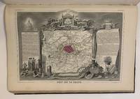
Paris: Amable Combette, 1852. Folio atlas in contemporary half calf, gilt title to front board and spine; re-backed and rubbed with corners repaired, slight warping. Engraved illustrated title page, with statistical index of France and its colonies, listing 93 maps outlined in color including French Colonies and a world map. There are 8 bonus map including France in 1852, Europe, Africa, South America, North America (still separating Texas as a Republic), Asia, L'Oceania and a lovely double page postal map of France. (101 maps in total). Some foxing and toning to first three sheets otherwise in very good condition. Paris : Amable Combette, 1852.<br/> <br/> Wonderful atlas with each map framed in an elaborate pictorial border and lavish illustrations. Victor Levasseur (1800 - 1870) was a French cartographer, engineer and engraver well known for his elaborate map style.<br/> <br/>
Reviews
(Log in or Create an Account first!)
Details
- Bookseller
- Argosy Book Store
 (US)
(US)
- Bookseller's Inventory #
- 308467
- Title
- Atlas National Illustre des 86 Departements et des Possessions de la France divise par Arrondissements, Cantons et Communes. Avec le trace de toutes les routes, chemins de fer et canaux
- Author
- LEVASSEUR, Victor
- Book Condition
- Used
- Quantity Available
- 1
- Publisher
- Amable Combette
- Place of Publication
- Paris
- Date Published
- 1852
Terms of Sale
Argosy Book Store
All items are offered net, subject to prior sale. Returns accepted within 7 days of receipt--please contact us first. Payment by Visa , Mastercard & American Express. Appropriate sales tax will be added for all N.Y. State residents
About the Seller
Argosy Book Store
Biblio member since 2004
New York, New York
About Argosy Book Store
We are a large retail store, with 6 floors of out-of-print and rare books, (including, Americana, modern first editions, history of medicine and science), antique maps and prints, autograph manuscripts, letters & signatures.
Glossary
Some terminology that may be used in this description includes:
- Title Page
- A page at the front of a book which may contain the title of the book, any subtitles, the authors, contributors, editors, the...
- Gilt
- The decorative application of gold or gold coloring to a portion of a book on the spine, edges of the text block, or an inlay in...
- Folio
- A folio usually indicates a large book size of 15" in height or larger when used in the context of a book description. Further,...
- Re-backed
- Describes a book that has had the material covering the spine replaced or joints mended.
- Calf
- Calf or calf hide is a common form of leather binding. Calf binding is naturally a light brown but there are ways to treat the...
This Book’s Categories

Is your family bible valuable?
While they may have sentimental value, bibles passed down through the family are not often worth a lot of money. Learn more...