Description:
G. W. Bacon & Co. Ltd, 1111. Hardcover. Acceptable. No Edition Remarks. Unpaginated. No dust jacket. Green cloth with gilt lettering. Colour fold out map within. Sheet No. 5. Moderate tanning to map with minor water stains and creasing to folds; picture and text unaffected. Binding hinges are lightly cracked but boards remain together. Some small stamps to reverse of map segments. Boards have minor corner bumping and edgewear with heavy water staining, tanning and scuffing overall. Spine has light tanning with soft crushing to ends. Lettering remains bright and clear.
Bacon's Cycling Road Map of England, Sheet 2, North by - - 1890
by -
Similar copies are shown below.
Similar copies are shown to the right.
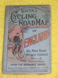
Bacon's Cycling Road Map of England, Sheet 2, North
by -
- Used
- fair
- Hardcover
G W Bacon & Co Ltd, 1890. Fair. 175 x 110mm, opens to 635 x 880mm. Coloured map. Map Condition: Fair, given it's age, cloth cover clean, bright, some rubbing/folding to edges, normal due to overlapping map. The map has some open joints which I have decided not to repair in order for any buyer to see condition before repair. Undated, believe 1890? Comments: An early 'cycling' map from G W Bacon for the North of England, sheet 2 of 7. Scale 5 miles to 1 inch. . Fair. 175 x 110mm, opens to 635 x 880mm.
-
Bookseller
Pullet's Books
 (GB)
(GB)
- Book Condition Used - Fair
- Quantity Available 1
- Binding Hardcover
- Publisher G W Bacon & Co Ltd
- Date Published 1890
- Size 175 x 110mm, opens to 635 x 880m
- Size 175 x 110mm, opens to 635 x 880mm
We have 4 copies available starting at $13.48.

Bacon's Cycling Road-Map of England, Sheet No. 5
by Unstated
- Used
- Acceptable
- Hardcover
- Condition
- Used - Acceptable
- Binding
- Hardcover
- Quantity Available
- 1
- Seller
-
Goring-by-Sea, West Sussex, United Kingdom
- Item Price
-
$13.48
Show Details
Item Price
$13.48

Bacon's Cycling Road-Map of England, Sheet No. 2
by Bacon & Co
- Used
- Paperback
- first
- Condition
- Used - Good+
- Edition
- First Edition.
- Binding
- Paperback
- Quantity Available
- 1
- Seller
-
Bere Alston, Devon, United Kingdom
- Item Price
-
$14.68
Show Details
Description:
London: Bacon & Co., 1890. First Edition. . Paperback. Good+. linen backed blue cover with cyclist
Item Price
$14.68

Bacon's Cycling Road-Map of England: Sheet No. 6 - Fifty Miles around London
by Bacon
- Used
- very good
- Paperback
- Condition
- Used - Very Good
- Binding
- Paperback
- Quantity Available
- 1
- Seller
-
Hartland, Michigan, United States
- Item Price
-
$29.25
Show Details
Description:
G. W. Bacon. Very Good. Softcover. 16mo in original covers, wraps, still tight, clean map which folds out (15 panels) revealing a detailed map in color, with many trails in red. Map in very nice condition. In front shows location of this map compared to others; additionally thee is an illustrated ad for Rover Cycles. ; 16mo 6" - 7" tall .
Item Price
$29.25

Bacon's Cycling Road-Map Of England And Wales: Manchester
- Used
- Paperback
- first
- Condition
- Used - Good+ with no dust jacket
- Edition
- First Edition
- Binding
- Paperback
- Quantity Available
- 1
- Seller
-
Dunedin, New Zealand, New Zealand
- Item Price
-
$40.00
Show Details
Description:
London: G. W. Bacon & Co. Good+ with no dust jacket. First Edition. Softcover. Some rubbing, fading and marking to wrappers. ; No date [c. 1920s?]. Cover title, "Bacon's Large Scale Plan Of Manchester." Red cloth wrappers with black illustration. Contains one folding map.; 16mo 6" - 7" tall .
Item Price
$40.00