Description:
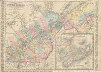
Philadelphia: Charles Desilver, 1856. 17¼" X 13 3/4" (image 15½" X 12¼"). Hand colored. Very good. Light foxing and age toning. Quite clean and lovely example, with sharp decorative border and large inset at lower right showing "Novia Scotia New Brunswick &c.
Canada East Formerly Lower Canada. by CANADA 1846 HANDCOLOR) - Copyright 1846by H.N. Burroughs.
by CANADA 1846 HANDCOLOR)
Similar copies are shown below.
Similar copies are shown to the right.

Canada East Formerly Lower Canada.
by CANADA 1846 HANDCOLOR)
- Used
Philadelphia.: S. Augustus Mitchell.. Copyright 1846by H.N. Burroughs.. Map, handcolored, 12 1/2 x 15 1/2 in. including decorative border. Overall light soiling not noticeable in image area, repaired tear just entering border at left and at top edges, couple of short tears at lower edge, small spot just outside right border, otherwise very good condition. Inset map at lower right "Nova Scotia, New Brunswick &c." (6 x 6 inches), shows islands of Nova Scotia, Prince Edwards Island and Cape Breton Island. .
-
Bookseller
Independent bookstores
 (US)
(US)
- Book Condition Used
- Publisher S. Augustus Mitchell.
- Place of Publication Philadelphia.
- Date Published Copyright 1846by H.N. Burroughs.
- Keywords Canada, map, Montreal, New Brunswick, Nova Scotia, Quebec, zz_ListOn_eBay, zzmapg
We have 1 copies available starting at $95.00.
Canada East Formerly Lower Canada
by (CANADA EAST -- Map)
- Used
- Condition
- Used
- Quantity Available
- 1
- Seller
-
Galena, Illinois, United States
- Item Price
-
$95.00
Show Details
Item Price
$95.00