
Click for full-size.
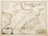
CARTE DE LA PARTIE DE L'OCEAN: Vers l'Equateur entre les Cotes D'AFRIQUE et D'AMERIQUE Où la Situation des Isles, Bancs, et Vigies, montre qu'elles peuvent être soit la cause des variétés observées dans les Courants de ces Mers; Dressées par Philippe Buache Premier Géographe de
by BUACHE, Philippe, 1700-1773
- Used
- Condition
- See description
- Seller
-
London, United Kingdom
Payment Methods Accepted
About This Item
Atlas de Geographie., Sept 1737.. An interesting geo-hydrographic map of the Atlantic Ocean and its islands. It is divided into two with one side showing the Atlantic Ocean and the coasts of Africa and Brazil and the other side a detailed examination of the archipelago of Fernando de Noronha. A note top left explains the purpose of the map, which in brief is to give an idea of the variety of islands in the Atlantic Ocean. Another note top right explains a little about the cartographers and expedition members. Another explains about an embankment between islands on the archipelago. A cartouche top right contains a cross-section diagram of what is below sea level. Another below sea-level cross-section shows the particulars of Fernando de Noronha lower right corner. Copper engraving. Original colour. Very good condition - slight dark patches to lower corners and repair to lower left margin. Some offsetting. Size: 65 x 49.5 cm. (25½ x 19½ inches)
Reviews
(Log in or Create an Account first!)
Details
- Bookseller
- Peter Harrington
 (GB)
(GB)
- Bookseller's Inventory #
- 55258
- Title
- CARTE DE LA PARTIE DE L'OCEAN
- Author
- BUACHE, Philippe, 1700-1773
- Book Condition
- Used
- Place of Publication
- Atlas de Geographie.
- Date Published
- Sept 1737.
Terms of Sale
Peter Harrington
All major credit cards are accepted. Both UK pounds and US dollars (exchange rate to be agreed) accepted. Books may be returned within 14 days of receipt for any reason, please notify first of returned goods.
About the Seller
Peter Harrington
Biblio member since 2006
London
About Peter Harrington
Since its establishment, Peter Harrington has specialised in sourcing, selling and buying the finest quality original first editions, signed, rare and antiquarian books, fine bindings and library sets. Peter Harrington first began selling rare books from the Chelsea Antiques Market on London's King's Road. For the past twenty years the business has been run by Pom Harrington, Peter's son.
Glossary
Some terminology that may be used in this description includes:

What is a first edition?
Even if you’re only peripherally aware of book collecting, you’ve doubtless heard the term, first edition, bandied about but you may still be in the dark as to what makes them such a big deal. Learn about first editions and why collectors value them here.

Collecting the Harlem Renaissance
One of the most influential - and certainly most iconic - cultural revolutions in American history, the Harlem Renaissance offers a compelling repertoire for both seasoned and novice book collectors. We’ve put together a beautiful gallery of high points to help start your collection here.