Description:
Paperback / softback. New.
Central Park, New York City - The Grand Drive. by NEW YORK - NEW YORK CITY CENTRAL PARK) Waud, A. R - 12-16- 1865.
by NEW YORK - NEW YORK CITY CENTRAL PARK) Waud, A. R
Similar copies are shown below.
Similar copies are shown to the right.

Central Park, New York City - The Grand Drive.
by NEW YORK - NEW YORK CITY CENTRAL PARK) Waud, A. R
- Used
New York.: Harper's Weekly.. 12-16- 1865.. Double page wood-engraving from Harper's Weekly magazine December 16, 1865, sheet size 16 x 22 1/2 inches, centrefold as issued. Six teeny binding holes (only noticeable when held to the light, very light dampstaining to two lower corners, otherwise in very good condition. Still bound in magazine which is missing the last page of the issue. A lively view of the New York populace taking the air in Central Park: horses, carriages, a balloon in the distance. .
-
Bookseller
oldimprints.com
 (US)
(US)
- Book Condition Used
- Publisher Harper's Weekly.
- Place of Publication New York.
- Date Published 12-16- 1865.
- Keywords New York, New York City, Transportation, wood-engraving, zz_22_WS_40_off, zzprintg
We have 5 copies available starting at $23.51.

Report Of The New York Meteorological Observatory Of The Department Of Parks, Central Park, New York City
by New York (N Y ) Meteorological Observ
- New
- Paperback
- Condition
- New
- Binding
- Paperback
- ISBN 10 / ISBN 13
- 9781022363960 / 1022363964
- Quantity Available
- 10
- Seller
-
Southport, Merseyside, United Kingdom
- Item Price
-
$23.51
Show Details
Item Price
$23.51

Stock Photo: Cover May Be Different
Report Of The New York Meteorological Observatory Of The Department Of Parks, Central Park, New York City
by New York (N Y ) Meteorological Observ
- New
- Hardcover
- Condition
- New
- Binding
- Hardcover
- ISBN 10 / ISBN 13
- 9781020413568 / 1020413565
- Quantity Available
- 10
- Seller
-
Southport, Merseyside, United Kingdom
- Item Price
-
$38.27
Show Details
Description:
Hardback. New.
Item Price
$38.27
CENTRAL PARK CARRIAGE SERVICE, ORGANIZED 1869. [At head: 1857. CITY OF NEW YORK. 1883. DEPARTMENT OF PUBLIC PARKS. CENTRAL PARK, FOUNDED 1857.]
by New York Department of Public Parks
- Used
- Condition
- Used
- Quantity Available
- 1
- Seller
-
Woodbridge, Connecticut, United States
- Item Price
-
$75.00
Show Details
Description:
New York: M.J. Roth, Printer and Stationer, 1883. 3.5" x 5.5". [4] pp, illustrations. Caption title [as issued], folded. Woodcut illustration of horse and carriage on title page, woodcut illustration of obelisk on second page. Light age toning. Light horizontal fold, light wear. About Very Good. This rare, ephemeral pamphlet prints the Central Park Carriage Service's pick-up locations, points of interest, details of Central Park's mileage and acreage, names and locations of all park gates, history and description of the Obelisk monument, and general visitor information such as availability of refreshments and location of police. OCLC 58764784 [1-NYHS].
Item Price
$75.00
More Photos
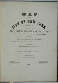
Map of the City of New York. Parts I & II. Showing the Streets, Avenues, Roads, Public Squares & Places Laid Out, Established, Widened and Retained, the New Pier and Bulkhead Lines Laid Out and Established, by the Board of Commissioners of the Central Park. Atlas
by [New York City; Upper West Side; Maps] Sackersdorff, Otto
- Used
- Hardcover
- Condition
- Used - Very good + condition
- Binding
- Hardcover
- Quantity Available
- 1
- Seller
-
Garrison, New York, United States
- Item Price
-
$3,500.00
Show Details
Description:
New York, 1872. Hardcover. Very good + condition. Maps of Manhattan's west side, prior to the completion of Central Park, which was finished in 1876. The maps were compiled by longtime New York City Department of Public Works map clerk and city surveyor Otto Sackersdorff, noted for his 'Maps of Farms, Commonly called The Blue Book, 1815". The Blue Book was not published until 1868, as a demonstration of northern economic might at the end of the Civil War. The real estate maps show property lines, existing roads, parks, shorelines, wetlands, and the Manhattan grid, extending from west of 8th Avenue at 59th Street and Columbus Circle up to 222nd Street and Spuyten Duyvil & Kingsbridge. Parks and major thoroughfares include: Central Park, St. Nicholas Avenue, Fort Washington Park, Kingsbridge Road, and High Bridge Park. Folio, 15 x 20 1/2", 14 maps in total: 1 full page and 13 double page (28 x 20") hand colored lithographed map sheets. Each map contiguous with one another. Period quarter green gilt…
Read More Item Price
$3,500.00
Map of the City of New York North of 155th St. Showing the progress made in laying out Streets, Avenues, Roads, Public Squares and Places by the Commissioners of Central Park
by (New York City) Ewen, Edward S. and Hamilton Ewen
- Used
- Condition
- Used - Folds in publisher's cloth case, upper cover detached, publisher's title on the front pastedown. Signature on verso dated 1873
- Quantity Available
- 1
- Seller
-
New York, New York, United States
- Item Price
-
$3,500.00
Show Details
Description:
New York: Edward S. Ewen, 1873. Hand colored lithographed folding map, sectioned and linen-backed as issued. 24 x 67 inches. Folds in publisher's cloth case, upper cover detached, publisher's title on the front pastedown. Signature on verso dated 1873. Hand colored lithographed folding map, sectioned and linen-backed as issued. 24 x 67 inches. Early Large Scale Mapping of the Development of Upper Manhattan. The famed Commissioner's plan of 1811, which laid out New York's street's in the grid pattern which would dictate the city's development, anticipate its massive population growth in the 19th century and cartographically define the city to this day, ended ubruptly and arbitrarily at 155th street. In 1865, Comptroller of the Central Park Commission Andrew Haswell Green began planning for development north of the grid. With the war at an end and with the construction of Central Park completed, Green saw the need for the development of Manhattan north of the park and the advantages of it being…
Read More Item Price
$3,500.00