Description:
Europe: Antwerp Joannem Bapt. Vrientium/ Vrients. 1601. Copper engraved minature map by Phillip Galle of Picardy, France, from" Epitome theatri Orteliani praecipuarum orbis regionum delinaetiones. . Editio ultima" Latin text to verso, describing the succeeding map. . Dark impression; overall toning; light foxing/staining to blank margins. The first edition of the"Epitome" in 1577, a reduced format atlas, with minature maps of Abraham Ortelius's "Theatrum" is believed to have been the initiative of the engraver Phillip Galle who asked Peter Heyns to write the text. Ortelius had fled to England in 1576 having taken refuge there from Spanish oppression, and may have been unaware of the plan of his two friends. The pocket atlas was a a commmercial success and was reprinted several times with Galle adding many new maps, and replacing some. Jan. Baptist, Vrients bought the rights and plates of the Epitome from Phillip Galle in 1601, . he published 4 editions using the Galle plates of which this is the…
Read More Culiacana Provincia; Cuba, et Spagniola; " Hispaniolae, Cubae, Aliarumque Insularum Circumiacente, Delineato" with "Culicanae .Americae Descriptio by Ortelius, Abraham
by Ortelius, Abraham

Culiacana Provincia; Cuba, et Spagniola; " Hispaniolae, Cubae, Aliarumque Insularum Circumiacente, Delineato" with "Culicanae .Americae Descriptio
by Ortelius, Abraham
- Used
Americas.: Antverpiæ"/Antwerp. "ex Officiana Plantiana" . Plantijn Christoffel. 1595. Copper engraved map showing Cuba, Hispaniola and the surrounding islands , including the tip of Florida, with above a map of Culcanea , south western coast of Mexico from Ortelius' "Theatrum Orbis Terrarum" 1595 edition; black & white. Latin text to verso. Decorative cartouche ; gallion to sea. Good dark impression. Abraham Ortelius,[ 1527-1598] Flemish Cartographer . produced the first modern Atlas "Theatrum Orbis Terrarum" in 1570. printed by Aegidus Coppen Diest. There were numerous editions thereafter with texts in various languages; the printing of such was taken over by Chrstoffel Plantijn in 1579 . Ortelius himself drew all the maps in manuscript before passing them to the printers. there is conjecture that he may have engraved some of the plates as well The 1595 Latin text edition is the most complete produced during his lifetime, containing all the maps of the 1593 edition plus those of the the"Additamentum" and the"Pareragon" or Ancient geography. The " Additamenta" were supplements to the original Atlas; at the same time Ortelius replaced some maps with new ones showing the same place; some plates were also reworked . Ortelius was Geographer Royal To Phillip II of Spain from 1575. He also worked closely with Braun & Hogenburg on the "Civitas Orbis Terarum". After his death the plates were purchased by Jan Baptiste Vrients in 1601 who published further editions until 1612. Van de Krogt; 3; .Koeman:Ort29/ 8; van den Broecke:14a,b. Americas. Cuba & Mexico Cuba Hispaniola Cacunae Mexico
-
Bookseller
Mary Louise Bryan/Paralos Gallery
 (GR)
(GR)
- Book Condition Used
- Publisher Antverpiæ"/Antwerp. "ex Officiana Plantiana" . Plantijn Christoffel. 1595
- Place of Publication Americas.

Picardia. "
by Ortelius, Abraham
- Used
- first
- Condition
- Used
- Quantity Available
- 1
- Seller
-
Nafplion, Greece
- Item Price
-
$32.74
Show Details
Item Price
$32.74
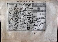
Westfalia. "
by Ortelius, Abraham
- Used
- first
- Condition
- Used
- Quantity Available
- 1
- Seller
-
Nafplion, Greece
- Item Price
-
$32.74
Show Details
Description:
Europe: Antwerp Joannem Bapt. Vrientium/ Vrients. 1601. Copper engraved minature map by Phillip Galle of Westphalia, Germany, from" Epitome theatri Orteliani praecipuarum orbis regionum delinaetiones. . Editio ultima" Latin text to verso, describing the succeeding map. . Dark impression, overall toning, light foxing to blank margins. Light dampstaining to blank margins. The first edition of the"Epitome" in 1577, a reduced format atlas, with minature maps of Abraham Ortelius's "Theatrum" is believed to have been the initiative of the engraver Phillip Galle who asked Peter Heyns to write the text. Ortelius had fled to England in 1576 having taken refuge there from Spanish oppression, and may have been unaware of the plan of his two friends. The pocket atlas was a a commmercial success and was reprinted several times with Galle adding many new maps, and replacing some. Jan. Baptist, Vrients bought the rights and plates of the Epitome from Phillip Galle in 1601, . he published 4 editions using the…
Read More Item Price
$32.74

Poitou. " "Pictavia
by Ortelius, Abraham
- Used
- first
- Condition
- Used
- Quantity Available
- 1
- Seller
-
Nafplion, Greece
- Item Price
-
$32.74
Show Details
Description:
Europe: Antwerp Joannem Bapt. Vrientium/ Vrients. 1601. Copper engraved minature map by Phillip Galle of Poitou/ Poitiers, Western France, from" Epitome theatri Orteliani praecipuarum orbis regionum delinaetiones. . Editio ultima" Latin text to verso, describing the succeeding map. . Dark impression; overall toning; light foxing/staining to blank margins. The first edition of the"Epitome" in 1577, a reduced format atlas, with minature maps of Abraham Ortelius's "Theatrum" is believed to have been the initiative of the engraver Phillip Galle who asked Peter Heyns to write the text. Ortelius had fled to England in 1576 having taken refuge there from Spanish oppression, and may have been unaware of the plan of his two friends. The pocket atlas was a a commmercial success and was reprinted several times with Galle adding many new maps, and replacing some. Jan. Baptist, Vrients bought the rights and plates of the Epitome from Phillip Galle in 1601, . he published 4 editions using the Galle plates of…
Read More Item Price
$32.74

Lemovicum. "
by Ortelius, Abraham
- Used
- first
- Condition
- Used
- Quantity Available
- 1
- Seller
-
Nafplion, Greece
- Item Price
-
$32.74
Show Details
Description:
Europe: Antwerp Joannem Bapt. Vrientium/ Vrients. 1601. Copper engraved minature map by Phillip Galle of Limoges, France, from" Epitome theatri Orteliani praecipuarum orbis regionum delinaetiones. . Editio ultima" Latin text to verso, describing the succeeding map. . Dark impression; overall toning; light foxing/staining to blank margins. The first edition of the"Epitome" in 1577, a reduced format atlas, with minature maps of Abraham Ortelius's "Theatrum" is believed to have been the initiative of the engraver Phillip Galle who asked Peter Heyns to write the text. Ortelius had fled to England in 1576 having taken refuge there from Spanish oppression, and may have been unaware of the plan of his two friends. The pocket atlas was a a commmercial success and was reprinted several times with Galle adding many new maps, and replacing some. Jan. Baptist, Vrients bought the rights and plates of the Epitome from Phillip Galle in 1601, . he published 4 editions using the Galle plates of which this is the…
Read More Item Price
$32.74

Regiones Biturigum exacti descriptio. "
by Ortelius, Abraham
- Used
- first
- Condition
- Used
- Quantity Available
- 1
- Seller
-
Nafplion, Greece
- Item Price
-
$32.74
Show Details
Description:
Europe: Antwerp Joannem Bapt. Vrientium/ Vrients. 1601. Copper engraved minature map by Phillip Galle of Bourges France, from" Epitome theatri Orteliani praecipuarum orbis regionum delinaetiones. . Editio ultima" Latin text to verso, describing the succeeding map. . Dark impression; overall toning; light foxing/staining to blank margins. The first edition of the"Epitome" in 1577, a reduced format atlas, with minature maps of Abraham Ortelius's "Theatrum" is believed to have been the initiative of the engraver Phillip Galle who asked Peter Heyns to write the text. Ortelius had fled to England in 1576 having taken refuge there from Spanish oppression, and may have been unaware of the plan of his two friends. The pocket atlas was a a commmercial success and was reprinted several times with Galle adding many new maps, and replacing some. Jan. Baptist, Vrients bought the rights and plates of the Epitome from Phillip Galle in 1601, . he published 4 editions using the Galle plates of which this is the…
Read More Item Price
$32.74

Burgundiae Ducatus. "
by Ortelius, Abraham
- Used
- first
- Condition
- Used
- Quantity Available
- 1
- Seller
-
Nafplion, Greece
- Item Price
-
$32.74
Show Details
Description:
Europe: Antwerp Joannem Bapt. Vrientium/ Vrients. 1601. Copper engraved minature map by Phillip Galle of the Duchy of Burgundy, France, from" Epitome theatri Orteliani praecipuarum orbis regionum delinaetiones. . Editio ultima" Latin text to verso, describing the succeeding map. . Dark impression; overall toning; light foxing/staining to blank margins. The first edition of the"Epitome" in 1577, a reduced format atlas, with minature maps of Abraham Ortelius's "Theatrum" is believed to have been the initiative of the engraver Phillip Galle who asked Peter Heyns to write the text. Ortelius had fled to England in 1576 having taken refuge there from Spanish oppression, and may have been unaware of the plan of his two friends. The pocket atlas was a a commmercial success and was reprinted several times with Galle adding many new maps, and replacing some. Jan. Baptist, Vrients bought the rights and plates of the Epitome from Phillip Galle in 1601, . he published 4 editions using the Galle plates of which…
Read More Item Price
$32.74

Lotharingiae Typus. ' "
by Ortelius, Abraham
- Used
- first
- Condition
- Used
- Quantity Available
- 1
- Seller
-
Nafplion, Greece
- Item Price
-
$32.74
Show Details
Description:
Europe: Antwerp Joannem Bapt. Vrientium/ Vrients. 1601. Copper engraved minature map by Phillip Galle of the Lorraine, France, from" Epitome theatri Orteliani praecipuarum orbis regionum delinaetiones. . Editio ultima" Latin text to verso, describing the succeeding map. . Dark impression; overall toning; light foxing/staining to blank margins. The first edition of the"Epitome" in 1577, a reduced format atlas, with minature maps of Abraham Ortelius's "Theatrum" is believed to have been the initiative of the engraver Phillip Galle who asked Peter Heyns to write the text. Ortelius had fled to England in 1576 having taken refuge there from Spanish oppression, and may have been unaware of the plan of his two friends. The pocket atlas was a a commmercial success and was reprinted several times with Galle adding many new maps, and replacing some. Jan. Baptist, Vrients bought the rights and plates of the Epitome from Phillip Galle in 1601, . he published 4 editions using the Galle plates of which this is…
Read More Item Price
$32.74

La Mans, Cenomanorum Typus. "
by Ortelius, Abraham
- Used
- first
- Condition
- Used
- Quantity Available
- 1
- Seller
-
Nafplion, Greece
- Item Price
-
$32.74
Show Details
Description:
Europe: Antwerp Joannem Bapt. Vrientium/ Vrients. 1601. Copper engraved minature map by Phillip Galle of La Mans, France, from" Epitome theatri Orteliani praecipuarum orbis regionum delinaetiones. . Editio ultima" Latin text to verso, describing the succeeding map. . Dark impression; overall toning, some spots; light foxing/staining to blank margins. The first edition of the"Epitome" in 1577, a reduced format atlas, with minature maps of Abraham Ortelius's "Theatrum" is believed to have been the initiative of the engraver Phillip Galle who asked Peter Heyns to write the text. Ortelius had fled to England in 1576 having taken refuge there from Spanish oppression, and may have been unaware of the plan of his two friends. The pocket atlas was a a commmercial success and was reprinted several times with Galle adding many new maps, and replacing some. Jan. Baptist, Vrients bought the rights and plates of the Epitome from Phillip Galle in 1601, . he published 4 editions using the Galle plates of which…
Read More Item Price
$32.74

Aniou. " "Andegavensis Ducatus
by Ortelius, Abraham
- Used
- first
- Condition
- Used
- Quantity Available
- 1
- Seller
-
Nafplion, Greece
- Item Price
-
$32.74
Show Details
Description:
Europe: Antwerp Joannem Bapt. Vrientium/ Vrients. 1601. Copper engraved minature map by Phillip Galle of Anjou, France, from" Epitome theatri Orteliani praecipuarum orbis regionum delinaetiones. . Editio ultima" Latin text to verso, describing the succeeding map. . Dark impression, overall toning, light foxing to blank margins; one darker spot to lower blank margin The first edition of the"Epitome" in 1577, a reduced format atlas, with minature maps of Abraham Ortelius's "Theatrum" is believed to have been the initiative of the engraver Phillip Galle who asked Peter Heyns to write the text. Ortelius had fled to England in 1576 having taken refuge there from Spanish oppression, and may have been unaware of the plan of his two friends. The pocket atlas was a a commmercial success and was reprinted several times with Galle adding many new maps, and replacing some. Jan. Baptist, Vrients bought the rights and plates of the Epitome from Phillip Galle in 1601, . he published 4 editions using the Galle…
Read More Item Price
$32.74

Campania. "
by Ortelius, Abraham
- Used
- first
- Condition
- Used
- Quantity Available
- 1
- Seller
-
Nafplion, Greece
- Item Price
-
$32.74
Show Details
Description:
Europe: Antwerp Joannem Bapt. Vrientium/ Vrients. 1601. Copper engraved minature map by Phillip Galle of Champagne, France, from" Epitome theatri Orteliani praecipuarum orbis regionum delinaetiones. . Editio ultima" Latin text to verso, describing the succeeding map. . Dark impression; overall toning; light foxing/staining to blank margins. The first edition of the"Epitome" in 1577, a reduced format atlas, with minature maps of Abraham Ortelius's "Theatrum" is believed to have been the initiative of the engraver Phillip Galle who asked Peter Heyns to write the text. Ortelius had fled to England in 1576 having taken refuge there from Spanish oppression, and may have been unaware of the plan of his two friends. The pocket atlas was a a commmercial success and was reprinted several times with Galle adding many new maps, and replacing some. Jan. Baptist, Vrients bought the rights and plates of the Epitome from Phillip Galle in 1601, . he published 4 editions using the Galle plates of which this is the…
Read More Item Price
$32.74