
Click for full-size.
Expugnatio Sylvae-Ducis Ao 1629.: The Siege of the Swamp Dragon
by NIELS, Theodoor; SAVERIJ, Salomon [engraved figures after] VENNE, Adriaan van de; BERCKENRODE, Balthasar Florensz van [engraved map]
- Used
- Condition
- See description
- Seller
-
London, United Kingdom
Payment Methods Accepted
About This Item
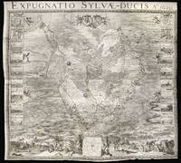
[Amsterdam],: H.J. Van Wouw,, 1631.. 1274 by 1405mm. (50.25 by 55.25 inches).. Engraved wall map on six sheets joined, eighteen inset views of the battle and siege works to left and right of the map. Large separately published six sheet map of the Siege of 's-Hertogenbosch during the Eighty Years War.
Hostilities between the Habsburg Empire and the Dutch Republic resumed in 1621, following the ending of the Twelve Years' Truce. The Habsburgs tried to punish the rebellious Dutch Republic by cutting it off from its hinterland by a land blockade. The blockade caused an economic crisis for the Republic and it reacted by trying to harm Spain in its colonies. In 1628, one of the many schemes undertaken met with spectacular success when Admiral Piet Hein of the Dutch West India Company captured the Spanish treasure fleet. With this windfall from the Stadtholder Frederick Henry decided to break the Habsburg blockade by launching a campaign against 's-Hertogenbosch.
's-Hertogenbosch, also known as moerasdraak (swamp dragon), was the main fortress in the Spanish blockading line, and enormous sums of money had been poured into the improvement of its defences. As the ground surrounding the city was a marsh, the city was generally deemed to be impregnable, as the water-saturated soil seemed to make an application of current siege methods such as trench-digging and undermining impossible.
The Siege
Frederick Hendrik laid siege to the city in April 1629, with an army of 24,000 infantry, 4,000 cavalry, and 4,000 peasants. He quickly set up a circumvallation and ordered the diverting of the two main streams feeding the swamps (the Dommel and the Aa) around the city by means of a forty kilometer long contravallation consisting of a double dike, which completely enclosed the fortress; having thus created a polder, he began to drain it by the use of horse drawn mills. After the soil had sufficiently dried out his siege trenches could begin to approach the city walls. So impressive were the siege works that noblemen travelled from throughout Europe to see them.
Attempts by the Habsburgs, under the command of Hendrik van den Bergh, Frederik's cousin, to relieve the city proved unsuccessful, as the circumvallation proved too strong, and Frederik's forces dug themselves ever closer to the city along the southern road from the direction of Vught, continuously bombarding the defences. During the siege 28,517 cannonballs were fired. On 18 July the large Fortress Isabella fell, followed the next day by Fort Anthony. Despite repeated sallies by the 2,500 men of the garrison, the attackers slowly worked their way to the southern city gate. There they undermined Bastion Vught; in the early hours of 11 September a massive explosion caused a large breach in the ramparts. On 14 September its military governor Anthonie Schetz surrendered the city.
The fall of 's-Hertogenbosch was an enormous blow to the prestige of the Spanish monarchy and the worst defeat in the North since the Spanish armada in 1588.[3] As a result their position in the North would soon crumble and Frederick Henry, encouraged by the success, would start a series of other sieges, assisted by his cousin Van den Bergh, who changed sides after being accused of treason.
The Map
The map on six sheets provides a complete narrative of the siege; to the left and right are 18 inset views (nine on each side), for seige works, dikes, and principal forts. To the foreground two figures of Mars and a river god hold up a plan of the city. A group of figures to the lower right depict, from right to left, Frederick Hendrik surveying the battle field, the artist Adriaan van de Venne, who turns his head to the viewer, and was responsible of the figurative work on the map, and the military engineer and author of the map Theodoor Niels, who is shown seated consulting a map. Beyond the immediate foreground several battle scenes are shown depicted various stages of the siege. To the centre of the map 's-Hertogenbosch is shown surrounded by the extensive siege works, the circumvallation line is clearly marked - a chain of small and larger fortifications connected with a continuous parapet - designed to withstand a relief attempt from the outside, and the smaller contravallation line and dike which Hendrick used to drain the swamp. Prominence is given to the Dutch camp at Vught south of the city. The intricate trench works, so vital for victory, are meticulously delineated and the breaching of the city wall is clearly marked. All prominent landmarks, and aspects of the siege are marked by a number that correlated with an explanatory text which accompanied the map.
The author of the map was Theodoor Niels, a military engineer in the Dutch army. Niels together with Jan Adriaansz Leeghwater, whose water mills and dike work had managed to dry the land surrounding the city, were the leading military engineers at the siege. Niels was principally responsible for the construction of the extensive trench network, which meant spending a great deal of time on the frontline; a fact that almost cost him his life, when on the night of the 22nd June 1629, the defenders exploded a mine under one of his trenches, burying him alive. Assumed death he was only rescued when his head and hands were spotted poking out from beneath the rubble. He was fated as a hero, and awarded a gold medal for his bravery. Unfortunately, his luck would eventually run out when, in 1633, he was killed during the battle of Rijnbeek.
On December 7th 1629, the States General recognized Niels vital role by not only awarding him a gold medal and a substantial cash sum, but also granting him a privilege of four years in order to produce a great map of the battle.
To enable him to complete the task Niels employed some of the leading artists and engravers working in Amsterdam at the time. These included: the figure and genre painter Adriaan van de Venne, who was responsible for the scenes in the foreground, and whose sketches would be engraved by Salomon Savery; the plan of the siege would be completed by Balthasar Florenz van Berckenrode, whose monumental wall map of Amsterdam, published in 1625, had met with such great praise, and whose map of Breda of 1637, bears striking similarity to the present work.
Rarity
We are only aware of four institutional examples, all of which are located in the Netherlands: Leiden University Library; Amsterdam Rjksprentenkabinet; Dordrecht, Museum Simon van Gijn; and Rotterdam, Atlas van Stolk.
Reviews
(Log in or Create an Account first!)
Details
- Bookseller
- Daniel Crouch Rare Books Ltd
 (GB)
(GB)
- Bookseller's Inventory #
- 14959
- Title
- Expugnatio Sylvae-Ducis Ao 1629.
- Author
- NIELS, Theodoor; SAVERIJ, Salomon [engraved figures after] VENNE, Adriaan van de; BERCKENRODE, Balthasar Florensz van [engraved map]
- Book Condition
- Used
- Publisher
- H.J. Van Wouw,
- Place of Publication
- [Amsterdam],
- Date Published
- 1631.
- Keywords
- Den Bosch, Niels, Saverij, Berckenrode, siege, 's-Hertogenbosch, Eighty Years War, rare map, antique map
- Product_type
- Maps
- Size
- 1274 by 1405mm. (50.25 by 55.25 inches).
Terms of Sale
Daniel Crouch Rare Books Ltd
Any item may be returned if you are not happy with it providing we are notified within 7 days of your receiving it. This does not affect any statutory rights you may have under UK or EU law for returning the item outside this period. All we ask is that you return the item(s) by the same or similar method to that in which they were sent to you. Your postage costs and any payment already received will be refunded immediately on our receipt of the items in the same condition as you received them.
About the Seller
Daniel Crouch Rare Books Ltd
Biblio member since 2018
London
About Daniel Crouch Rare Books Ltd
Daniel Crouch Rare Books is specialist dealer in antique atlases, maps, plans, sea charts and voyages dating from the fifteenth to the nineteenth centuries. Our carefully selected stock also includes a number of fine prints and globes, and a selection of cartographic reference books.Our particular passions include rare atlases, wall maps, and separately published maps and charts. We strive to acquire unusual and quirky maps that are in fine condition. We are members of the following trade associations: The Antiquarian Bookseller's Association (ABA); The British Antique Dealers' Association (BADA); Confédération Internationale des Négociantes en Oeuvres d'Art (CINOA); The International League of Antiquarian Booksellers (ILAB); The Society of London Art Dealers (SLAD); and The European Fine Art Foundation (TEFAF). Daniel and Nick are also both members of The Company of Art Scholars, Dealers, and Collectors.
Glossary
Some terminology that may be used in this description includes:

Beat Poet Michael McClure
From the fateful reading at Six-Gallery in 1955 to his novels, poetry, and stage productions, Michael McClure was right in the thick of the Beat Generation as it was born. See his books and art and learn more about the works of Michael McClure.

Collecting The Beat Generation
The Beat Generation was born out of WWII, and it still continues to exert considerable influence on today’s literary scene. Biblio sellers have a fantastic collection of Beat Generation books and ephemera for browsing.