Click for full-size.


The Geographical Magazine, Vol 1&2, 1874 & 1875. With West Australian, Arctic, Colorado & Fijian content
by Markham, Clements, edit. (Warburton; John Forrest; Ludwig Leichhardt)
- Used
- very good
- Hardcover
- first
- Condition
- Very good
- Seller
-
Garrison, New York, United States
Payment Methods Accepted
About This Item
London: Trubner & Co, 1874. First edition. Hard Cover. Very good. Very interesting accounts of both Warburton & John Forrest's presentation of papers to the society at the time of their West Australian explorations. Also includes an account of the Vienna Geographical Society meeting where it is announced that Hume had discovered the fate of Ludwig Leichhardt by talking to Classen, his companion, who had joined a tribe of aborigines.
Content includes, Volume 1:
Basin of Helmund, with large folding map "Map of a portion of Afghanistan, by Colonel Frazer Tytler"; Map showing the position of Hormuz Island by A.W. Stiffe; Viti or Fiji Islands with large folding map by E. G. Ravenstein; Roman Catholics in Great Britain (lge. folding map); Visit of Mr. Paderin to Karakorum with map; emigration article by Wm. Robinson including notes on assisted passages to Australia, etc; The Cameron expedition to Lake Tanganyika with map; Djetyshah (EasterN Turkistan) article by Robert Michell which concludes with him questioning Yakub's sovereignty with the Chinese determination to invade his territories, with map of Kashgar by E. Ravenstein; travels in Northern Persia by W. J. Gill (folding map); North American Boundary survey by Capt. Anderson (folding map); American exploration, the survey of Dr. F.V. Hayden; Formosa by E. G. Ravenstein with map; Robert Brown article "On Human Agency in the Dispersion of Plants" quoting ".,.. in New Zealand especially do we see this struggle for existence going on between Nature and introduced plants and animals..."; Markham, irrigation in Southern India, the Periyar Project with 2 maps; Abolition of the coolie traffic at Macau; From China to Peru, the emigration question by Clements Markham; continuing article throughout by Godfrey Turner on impressions of Jamaica with "Visit to Gov. Eyre";
Polar content includes Sherard Osborn article on routes to the North Polar region; Voyage of the Challenger by J.E. Davis, including information on sub-Antarctic Islands under Kerguelen, Tristan da'Cunha; German Polar volume by Robert Brown; The Arctic Campaign of 1874; the Austro-Hungarian Polar Expedition, 7pp by Lt. Julius Payer (with map); f
Vol. 2; Great African discovery of Lake Tanganyika by Lt. Cameron (lge. folding map) & another of his voyage round the lake (lge. folding map); Miklucho Maklay in New Guinea (Russian traveler); review of Livingstone's journals' Disco Bay North Greenland by Robert Brown; Great Tibet discovery of Lake Tengrinor; trade routes to Western China (lge folding map S.E. Asia); Italian exploration of New Guinea; travels in Great Tibet & trade routes between Tibet & Bengal by Markham; New state of Colorado by Alvan Southworth with Dr. Hayden expedition, 6 pp, interesting commentary on polygamy in Salt Lake City; folding map of Sir Douglas Forsyth's mission to Kashghar; letter from John Forrest to Sir Henry Rawlinson on his journey in Western Australia, 2pp, outlined before his paper delivered the next month; Nachtigalls travels in Africa (lge folding map); Capt. Napier's travels in Northern Persia; recent Russian exploration in Western Mongolia, Sosnovski & Miroshnichenko on the upper Irtysk (map); Zanzibar by Seyyid Barghash (folding map); Markham on the discovery of the course of the Congo; Olena expedition by Chekanovski & Muller (map);
Report on the presentation by John Forrest, June 28, 1875; notes in recent explorations in Central Asia; recent journeys in Paraguay by Mr. Cabot (lge. folding map).
Polar - Continuation of Challenger voyage in Antarctic Waters by J.E. Davis; work of the Arctic Expedition by Sir L. McClintock; Arctic expedition of Alert, Discovery & Valorous (lge. folding map).
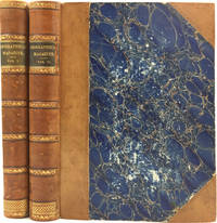
Two volumes, lge 4to, (iv), 394pp, 19 maps & (vi) 384pp, 21 maps. The maps are lithographed, sometimes in color. Half tan calf and marbled boards, slt. bumped o/w vgc. Other content includes the North American boundary survey, survey of the Mackenzie River, map of the Fiji Islands by Ravenstein, considerable Arctic content. A precursor to the "Proceedings of the Royal Geographical Society", which was printed in a smaller format. 4to magazine published in London. Uncommon magazine in a larger but similar format to the Royal Geographical Society journals. 1874 vol is illustrated by 19 maps, 1875 with 21 maps. Vol. 1 & 2 of a magazine that ran to 5 volumes total. OCLC 1570662. Trove 4559726.
Content includes, Volume 1:
Basin of Helmund, with large folding map "Map of a portion of Afghanistan, by Colonel Frazer Tytler"; Map showing the position of Hormuz Island by A.W. Stiffe; Viti or Fiji Islands with large folding map by E. G. Ravenstein; Roman Catholics in Great Britain (lge. folding map); Visit of Mr. Paderin to Karakorum with map; emigration article by Wm. Robinson including notes on assisted passages to Australia, etc; The Cameron expedition to Lake Tanganyika with map; Djetyshah (EasterN Turkistan) article by Robert Michell which concludes with him questioning Yakub's sovereignty with the Chinese determination to invade his territories, with map of Kashgar by E. Ravenstein; travels in Northern Persia by W. J. Gill (folding map); North American Boundary survey by Capt. Anderson (folding map); American exploration, the survey of Dr. F.V. Hayden; Formosa by E. G. Ravenstein with map; Robert Brown article "On Human Agency in the Dispersion of Plants" quoting ".,.. in New Zealand especially do we see this struggle for existence going on between Nature and introduced plants and animals..."; Markham, irrigation in Southern India, the Periyar Project with 2 maps; Abolition of the coolie traffic at Macau; From China to Peru, the emigration question by Clements Markham; continuing article throughout by Godfrey Turner on impressions of Jamaica with "Visit to Gov. Eyre";
Polar content includes Sherard Osborn article on routes to the North Polar region; Voyage of the Challenger by J.E. Davis, including information on sub-Antarctic Islands under Kerguelen, Tristan da'Cunha; German Polar volume by Robert Brown; The Arctic Campaign of 1874; the Austro-Hungarian Polar Expedition, 7pp by Lt. Julius Payer (with map); f
Vol. 2; Great African discovery of Lake Tanganyika by Lt. Cameron (lge. folding map) & another of his voyage round the lake (lge. folding map); Miklucho Maklay in New Guinea (Russian traveler); review of Livingstone's journals' Disco Bay North Greenland by Robert Brown; Great Tibet discovery of Lake Tengrinor; trade routes to Western China (lge folding map S.E. Asia); Italian exploration of New Guinea; travels in Great Tibet & trade routes between Tibet & Bengal by Markham; New state of Colorado by Alvan Southworth with Dr. Hayden expedition, 6 pp, interesting commentary on polygamy in Salt Lake City; folding map of Sir Douglas Forsyth's mission to Kashghar; letter from John Forrest to Sir Henry Rawlinson on his journey in Western Australia, 2pp, outlined before his paper delivered the next month; Nachtigalls travels in Africa (lge folding map); Capt. Napier's travels in Northern Persia; recent Russian exploration in Western Mongolia, Sosnovski & Miroshnichenko on the upper Irtysk (map); Zanzibar by Seyyid Barghash (folding map); Markham on the discovery of the course of the Congo; Olena expedition by Chekanovski & Muller (map);
Report on the presentation by John Forrest, June 28, 1875; notes in recent explorations in Central Asia; recent journeys in Paraguay by Mr. Cabot (lge. folding map).
Polar - Continuation of Challenger voyage in Antarctic Waters by J.E. Davis; work of the Arctic Expedition by Sir L. McClintock; Arctic expedition of Alert, Discovery & Valorous (lge. folding map).
Two volumes, lge 4to, (iv), 394pp, 19 maps & (vi) 384pp, 21 maps. The maps are lithographed, sometimes in color. Half tan calf and marbled boards, slt. bumped o/w vgc. Other content includes the North American boundary survey, survey of the Mackenzie River, map of the Fiji Islands by Ravenstein, considerable Arctic content. A precursor to the "Proceedings of the Royal Geographical Society", which was printed in a smaller format. 4to magazine published in London. Uncommon magazine in a larger but similar format to the Royal Geographical Society journals. 1874 vol is illustrated by 19 maps, 1875 with 21 maps. Vol. 1 & 2 of a magazine that ran to 5 volumes total. OCLC 1570662. Trove 4559726.
Reviews
(Log in or Create an Account first!)
Details
- Bookseller
- Antipodean Books, Maps & Prints
 (US)
(US)
- Bookseller's Inventory #
- 7905
- Title
- The Geographical Magazine, Vol 1&2, 1874 & 1875. With West Australian, Arctic, Colorado & Fijian content
- Author
- Markham, Clements, edit. (Warburton; John Forrest; Ludwig Leichhardt)
- Format/Binding
- Hard Cover
- Book Condition
- Used - Very good
- Quantity Available
- 1
- Edition
- First edition
- Binding
- Hardcover
- Publisher
- Trubner & Co
- Place of Publication
- London
- Date Published
- 1874
- Bookseller catalogs
- MAPS; AFRICA; NEW ZEALAND; ARCTIC;
- Note
- May be a multi-volume set and require additional postage.
Terms of Sale
Antipodean Books, Maps & Prints
30 day return guarantee, with full refund including shipping costs for up to 10 days after delivery if an item arrives mis-described or damaged.
About the Seller
Antipodean Books, Maps & Prints
Biblio member since 2009
Garrison, New York
About Antipodean Books, Maps & Prints
Booksellers for over 40 years, members of prominent trade associations (ABAA, ILAB, ANZAAB, IMCOS, ANZMS, PBFA). We are located at Garrison NY, a stone's throw from the Metro North Hudson line train, just over 1 hr. from NYC on the banks of the Hudson River. Books, maps, prints & ephemera bought & sold.
Glossary
Some terminology that may be used in this description includes:
- O/W
- An abbreviation for otherwise
- First Edition
- In book collecting, the first edition is the earliest published form of a book. A book may have more than one first edition in...
- Calf
- Calf or calf hide is a common form of leather binding. Calf binding is naturally a light brown but there are ways to treat the...
- SL.
- slight
- Marbled boards
- ...
- New
- A new book is a book previously not circulated to a buyer. Although a new book is typically free of any faults or defects, "new"...
- G
- Good describes the average used and worn book that has all pages or leaves present. Any defects must be noted. (as defined by AB...
Frequently asked questions
This Book’s Categories

Storing books - laying down or standing up?
Don’t unwittingly damage your growing book collection! Learn about when to store books laying down vs standing up. Read About Safe Book Storage

Collecting The Beat Generation
The Beat Generation was born out of WWII, and it still continues to exert considerable influence on today’s literary scene. Biblio sellers have a fantastic collection of Beat Generation books and ephemera for browsing.