Guide - Map of Jerusalem. For H.M. and Allied Forces. by ISRAEL - JERUSALEM) Gauer, Bernhard (mapmaker) - No date. Ca. 1930s.
by ISRAEL - JERUSALEM) Gauer, Bernhard (mapmaker)
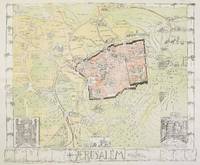
Guide - Map of Jerusalem. For H.M. and Allied Forces.
by ISRAEL - JERUSALEM) Gauer, Bernhard (mapmaker)
- Used
Jerusalem.: Boulos Afif.. No date. Ca. 1930s.. Color pictographic map, sheet 17 3/4 x 21 1/2 inches, folding into pictorial card folder, 9 x 4 3/4 inches. Light creasing to lower right panel of map, soft horizontal crease 1 3/4 inch from top of card where folded; overall very good condition. A very attractive map with decorative border of a wall with leafy plants, designed by Bernhard Gauer. There are pictographs of many of the landmarks of Jerusalem and an inset vignette at left of "Interior Di St. Sepulchre," in the centre of "Rachel's Tomb" and at right of "Mosque of Omar Dome of the Rock." The scale is 1:5000. There is a black and white map of Palestine and Southern Syria on the inside back cover. On the front cover there is the notation "For H.M. and Allied Forces" and the issue price of 35 mils. .
-
Bookseller
oldimprints.com
 (US)
(US)
- Book Condition Used
- Publisher Boulos Afif.
- Place of Publication Jerusalem.
- Date Published No date. Ca. 1930s.
- Keywords ephemera, Israel, Jerusalem, map, Palestine, pictographic map, pictorial map, zz_ListOn_eBay, zzephem, zzmapg