
Click for full-size.
Hammond's Complete Map of New Orleans, Louisiana Showing All Streets, Ferries, Electric and Steam Railroads, Parks, Etc.
by [Louisiana]
- Used
- Condition
- Very good plus.
- Seller
-
Dobbs Ferry, New York, United States
Payment Methods Accepted
About This Item
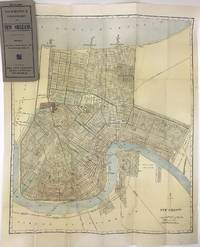
[New York, 1908. Very good plus.. Folding map, 23 x 19 inches folded to 7.5 x 3.5 inches. Original grey printed card covers. Minor wear to covers, a few small spots of foxing and wear to map. Handsome map of New Orleans printed in color, with the canals, railroads, and electric street car lines highlighted. The map depicts the city from Lake Pontchartrain to the Mississippi, showing minimal settlement south of the river, primarily in the neighborhood of Algiers. Audubon Park, Metairie Cemetery, the city park, and fair grounds are all highlighted, as are many other smaller squares, cemeteries, and green spaces, including the Oakland Driving Park (today the New Orleans Country Club's golf course). At the time, New Orleans was a city of about 300,000 people. The present map shows that most of the neighborhoods along the Mississippi were traversed by "electric railways," with one line traveling north to the lake and terminating at West End, while one line operated on the south side of the river. There are also numerous railroads delineated, and several ferries crossing the river. A detailed look at the streets of New Orleans at the turn of the century. We locate fewer than ten copies in OCLC.
Reviews
(Log in or Create an Account first!)
Details
- Bookseller
- McBride Rare Books
 (US)
(US)
- Bookseller's Inventory #
- 1418
- Title
- Hammond's Complete Map of New Orleans, Louisiana Showing All Streets, Ferries, Electric and Steam Railroads, Parks, Etc.
- Author
- [Louisiana]
- Book Condition
- Used - Very good plus.
- Quantity Available
- 1
- Place of Publication
- [New York
- Date Published
- 1908
- Weight
- 0.00 lbs
- Keywords
- BOSTON-VBF
Terms of Sale
McBride Rare Books
All items are guaranteed as described. Any purchase may be returned for a full refund within 10 working days as long as it is returned in the same condition and is packed and shipped correctly. All items subject to prior sale.
About the Seller
McBride Rare Books
Biblio member since 2018
Dobbs Ferry, New York
About McBride Rare Books
We specialize in American history, focusing on unique and eclectic materials such as archives, broadsides, vernacular photography, and interesting or unusual imprints. Particular fields of interest include Western Americana and Latin America.
Glossary
Some terminology that may be used in this description includes:
This Book’s Categories

Cleaning and repairing leather books
Wondering how to take care of the leather books in your collection? Renowned book care expert Bern Marcowitz explains how and when to clean and repair leather books.

The Importance of Dust Jackets
Is the dust jacket of a book worth holding on to? Consider its form, its function, and its beauty. Learn more about dust jackets and their importance to your collection.