Description:
Hanover House, 1961. Hardcover. Acceptable. Missing dust jacket; Readable copy. Pages may have considerable notes/highlighting. ~ ThriftBooks: Read More, Spend Less.Dust jacket quality is not guaranteed.
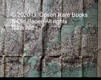
Hammond’s Enlarged Road Map of the Country Around New York. by C. S. Hammond - 1912
by C. S. Hammond
Hammond’s Enlarged Road Map of the Country Around New York.
by C. S. Hammond
- Used
- first
New York] Hammond's Enlarged Road Map of the Country Around New York. New York: C. S. Hammond & Co., 1912. Haskell, Manhattan Maps 1736. Scale 1 inch = 2 miles. 29 inches x 38 ½ inches, colored, printed on linen. Two small areas shown added coloring by a prior owner. Condition is fine, showing folds in the fabric. Copies were located at the American Geographical Society, the American Museum of Natural History and the University of Wisconsin at Milwaukee. The copy at the American Museum of Natural History is on paper with a cover. The copy at the University of Wisconsin is described as being "mounted on linen." The copy offered here is printed on linen and in color, without the cover, as issued by the publisher C. S. Hammond. The map shows roads, as well as road quality, interurban transportation lines, administrative boundaries, shipping piers, tunnels and canals.
-
Seller
G.Gosen Rare Books & Old Paper, ABAA, ILAB
 (US)
(US)
- Illustrator C. S. Hammond
- Format/Binding Printed on linen without the cover, as issued.
- Book Condition Used
- Quantity Available 1
- Edition First
- Publisher C. S. Hammond & Co.
- Place of Publication New York
- Date Published 1912
- Keywords Haskell, Road Maps,
- Size 29 in x 38 1/2 in

Hammond's Family Reference World Atlas
by C. S. Hammond
- Used
- Acceptable
- Hardcover
- Condition
- Used - Acceptable
- Binding
- Hardcover
- Quantity Available
- 1
- Seller
-
Seattle, Washington, United States
- Item Price
-
$6.95
Show Details
Item Price
$6.95
Hammond's Family Reference World Atlas
by C. S. Hammond
- Used
- good
- Hardcover
- Condition
- Used - Good
- Binding
- Hardcover
- Quantity Available
- 1
- Seller
-
Seattle, Washington, United States
- Item Price
-
$6.95
Show Details
Description:
Hanover House, 1961. Hardcover. Good. Pages can have notes/highlighting. Spine may show signs of wear. ~ ThriftBooks: Read More, Spend Less.Dust jacket quality is not guaranteed.
Item Price
$6.95
Hammond's Complete World Atlas
by C.S. Hammond Co
- Used
- Hardcover
- Condition
- UsedGood
- Binding
- Hardcover
- Quantity Available
- 1
- Seller
-
Tucker, Georgia, United States
- Item Price
-
$2.93
Show Details
Description:
UsedGood. All orders ship by next business day! This is a used hardcover book. Has no markings on pages. Pages have moderate wear. Dust jacket (if applicable) is not included. The cover/boards have moderate wear. Spine has been opened/creased. For USED books, we cannot guarantee supplemental materials such as CDs, DVDs, access codes and other materials. We are a small company and very thankful for your business!
Item Price
$2.93
Audubon Nature Program: Your Book of Nature Activities, Fun with Birds
by C. S. Hammond and Company
- Used
- good
- Paperback
- Condition
- Used - Good
- Binding
- Paperback
- Quantity Available
- 1
- Seller
-
Tolar, Texas, United States
- Item Price
-
$3.00
Show Details
Description:
Garden City, New York: Nelson Doubleday, Inc., 1953. The cover is lightly tanning. Pages are clean, text has no markings. . Soft Cover. Good. 8vo - over 7¾" - 9¾" tall. Ex-Libris.
Item Price
$3.00
Citation World Atlas
by Hammond C S and Co, Hammond Incorporated, Hammond Inc
- Used
- Condition
- Used - Good
- ISBN 10 / ISBN 13
- 9780843712544 / 0843712546
- Quantity Available
- 1
- Seller
-
Reno, Nevada, United States
- Item Price
-
$7.76
Show Details
Description:
Hammond World Atlas Corporation. Used - Good. Former library book; may include library markings. Used book that is in clean, average condition without any missing pages.
Item Price
$7.76
Citation World Atlas
by Hammond C S and Co, Hammond Incorporated, Hammond Inc
- Used
- Condition
- Used - Good
- ISBN 10 / ISBN 13
- 9780843712544 / 0843712546
- Quantity Available
- 1
- Seller
-
Reno, Nevada, United States
- Item Price
-
$7.76
Show Details
Description:
Hammond World Atlas Corporation. Used - Good. Used book that is in clean, average condition without any missing pages.
Item Price
$7.76
Citation World Atlas
by Hammond C S and Co, Hammond Incorporated, Hammond Inc
- Used
- Condition
- Used - Good
- ISBN 10 / ISBN 13
- 9780843712544 / 0843712546
- Quantity Available
- 1
- Seller
-
Mishawaka, Indiana, United States
- Item Price
-
$7.76
Show Details
Description:
Hammond World Atlas Corporation. Used - Good. Used book that is in clean, average condition without any missing pages.
Item Price
$7.76
Great Cities of the World
by editors at C. S. Hammond & Co
- Used
- good
- Hardcover
- first
- Condition
- Used - Good
- Jacket Condition
- Good
- Edition
- 1st Edition
- Binding
- Hardcover
- Quantity Available
- 1
- Seller
-
TORRINGTON, Wyoming, United States
- Item Price
-
$3.75
Show Details
Description:
Maplewood, NJ: C. S. Hammond & Co., 1958. Book. Illus. by Black & White, and Colored Photographs. Good. Hardcover. 1st Edition. 8vo - over 7¾" - 9¾" tall. G/G/ used hc, 384 pages. Teal paper cover with denim cloth encasing spine, gilt text on spine, lower corners bumped, else in good shape; end papers are map of world at that time. Dj has tiny chips and tears at extremities, nothing missing. Book includes street maps and photographs of the 147 cities covered. Interior pages are clean, no marking. Binding is tight..
Item Price
$3.75
The New Hammond World Atlas
by C. S. Hammond & Co., Inc
- Used
- good
- Paperback
- Condition
- Used - Good
- Binding
- Paperback
- Quantity Available
- 1
- Seller
-
Seattle, Washington, United States
- Item Price
-
$8.97
Show Details
Description:
Bantam Books, 1964. Paperback. Good. Disclaimer:A copy that has been read, but remains in clean condition. All pages are intact, and the cover is intact. The spine may show signs of wear. Pages can include limited notes and highlighting, and the copy can include previous owner inscriptions. At ThriftBooks, our motto is: Read More, Spend Less.Dust jacket quality is not guaranteed.
Item Price
$8.97

Great Cities of the World
by C.S. Hammond and Company
- Used
- good
- Hardcover
- Condition
- Used - Good
- Binding
- Hardcover
- Quantity Available
- 2
- Seller
-
Seattle, Washington, United States
- Item Price
-
$8.98
Show Details
Description:
C. S. Hammond and Company, 1958. Hardcover. Good. Pages can have notes/highlighting. Spine may show signs of wear. ~ ThriftBooks: Read More, Spend Less.Dust jacket quality is not guaranteed.
Item Price
$8.98