
Click for full-size.
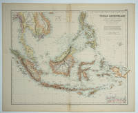
Indian Archipelago compiled from the various surveys of the British & Dutch Governments
by Bartholomew, J. Junr
- Used
- Condition
- Very good condition
- Seller
-
Garrison, New York, United States
Payment Methods Accepted
About This Item
Edinburgh: A. Fullarton & Co, 1872. Very good condition. Subtitle"... and Other Materials in Possession of the Royal Geographical Society." Lithograph with printed color. Plate number "LXX" in the top right corner. Center fold. 21 x 17" plus margins.
"1st edition 1864; published in 27 parts 1854-62. The date of 1872 is estimated by the Australia map; all the maps are undated and probably date throughout the period 1864 to 1872: the North America map shows Colorado and Russian America while the United States map has no Colorado. The World maps show Alaska. This is the last highly decorative atlas published in England. Even the maps without views or figures are beautifully engraved and colored with a mixture of printed color and hand color. Swanston, Petermann, Bartholomew, Macnab and Johnson engraved the maps. The introduction by Shaw among other things lists important general atlases published over a long period. He lists only one United States atlas, Mitchell's Universal Atlas of 1853!" (David Rumsey's fine website).
"1st edition 1864; published in 27 parts 1854-62. The date of 1872 is estimated by the Australia map; all the maps are undated and probably date throughout the period 1864 to 1872: the North America map shows Colorado and Russian America while the United States map has no Colorado. The World maps show Alaska. This is the last highly decorative atlas published in England. Even the maps without views or figures are beautifully engraved and colored with a mixture of printed color and hand color. Swanston, Petermann, Bartholomew, Macnab and Johnson engraved the maps. The introduction by Shaw among other things lists important general atlases published over a long period. He lists only one United States atlas, Mitchell's Universal Atlas of 1853!" (David Rumsey's fine website).
Reviews
(Log in or Create an Account first!)
Details
- Bookseller
- Antipodean Books, Maps & Prints
 (US)
(US)
- Bookseller's Inventory #
- 26740
- Title
- Indian Archipelago compiled from the various surveys of the British & Dutch Governments
- Author
- Bartholomew, J. Junr
- Book Condition
- Used - Very good condition
- Quantity Available
- 1
- Publisher
- A. Fullarton & Co
- Place of Publication
- Edinburgh
- Date Published
- 1872
- Bookseller catalogs
- MAPS; AUSTRALIA;
Terms of Sale
Antipodean Books, Maps & Prints
30 day return guarantee, with full refund including shipping costs for up to 10 days after delivery if an item arrives mis-described or damaged.
About the Seller
Antipodean Books, Maps & Prints
Biblio member since 2009
Garrison, New York
About Antipodean Books, Maps & Prints
Booksellers for over 40 years, members of prominent trade associations (ABAA, ILAB, ANZAAB, IMCOS, ANZMS, PBFA). We are located at Garrison NY, a stone's throw from the Metro North Hudson line train, just over 1 hr. from NYC on the banks of the Hudson River. Books, maps, prints & ephemera bought & sold.
Glossary
Some terminology that may be used in this description includes:
This Book’s Categories

Collecting One Book
Instead of collecting by series, author, publisher...why not just one title? Learn more about collecting variations and editions of one book.

Cleaning and repairing leather books
Wondering how to take care of the leather books in your collection? Renowned book care expert Bern Marcowitz explains how and when to clean and repair leather books.