Description:
Washington, D.C.: Government Printing Office, 1891. From the Atlas to Accompany the Official Records of the Union and Confederate Armies, 1861-1865..moderate insect damage at upper corner margin [2 scans = almost full image]. 1st. Unbound. Very Good. Illus. by Colored Map. 18" x 29".
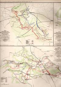
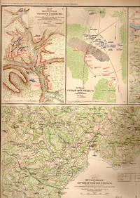
MAP: 11 Battlefield Maps of Milford, Virginia, Lacey Spring, VA, Beverly, VA; Brock's Gap, Liberty Mills, Rude's Hill, Moorefield, New Creek & Vicinity, Gordonsville, Etc. Plus 24 Sjetches of Positions ffrom Jed Hotchkiss Confederate Army Journal by United States War Department - 1891
by United States War Department
Similar copies are shown below.
Similar copies are shown to the right.

MAP: 11 Battlefield Maps of Milford, Virginia, Lacey Spring, VA, Beverly, VA; Brock's Gap, Liberty Mills, Rude's Hill, Moorefield, New Creek & Vicinity, Gordonsville, Etc. Plus 24 Sjetches of Positions ffrom Jed Hotchkiss Confederate Army Journal
by United States War Department
- Used
- very good
- Paperback
- first
Washington, D.C.: Government Printing Office, 1891. First Thus editon; Plate LXXXIV From the Atlas to Accompany the Official Records of the Union & Confederate Armies, 1861-1865. ; Lovely, and suitable for framing [2 scans=full image]. 1st. Unbound. Very Good. Illus. by Colored Map. 18" x 29".
-
Bookseller
Dorley House Books
 (US)
(US)
- Illustrator Colored Map
- Format/Binding Paperback
- Book Condition Used - Very Good
- Edition 1st
- Binding Paperback
- Publisher Government Printing Office
- Place of Publication Washington, D.C.
- Date Published 1891
- Keywords Civil War;
- Size 18" x 29"
We have 41 copies available starting at $65.00.
More Photos
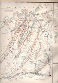
MAP: 6 Section Map, Including the Battle Field of the Wilderness, Virginia, North Anna, Bethesda Church, Daltn, Georgia, Spotsylvania, and Todd's Tavern
by United States War Department
- Used
- very good
- Paperback
- first
- Condition
- Used - Very Good
- Edition
- 1st
- Binding
- Paperback
- Quantity Available
- 1
- Seller
-
Hagerstown, Maryland, United States
- Item Price
-
$65.00
Show Details
Item Price
$65.00

MAP: 14 Sketches, and Maps of Battles of Chickamauga, Georgia, Bristoe Station, Manassas Junction, Fort Creighton, Chattanooga, Tennessee, Fort Jones, Cleveland, Tennessee, Fort Phelps, Etc
by United States War Department
- Used
- near fine
- Paperback
- Condition
- Used - Near Fine
- Binding
- Paperback
- Quantity Available
- 1
- Seller
-
Hagerstown, Maryland, United States
- Item Price
-
$75.00
Show Details
Description:
Washington, D.C.: Government Printing Office, 1891. Plate CXI, From the Atlas to Accompany the Official Records of the Union & Confederate Armies, 1861-1865. ; Lovely, and suitable for framing. Unbound. Near Fine. Illus. by Colored Map. 18" x 29".
Item Price
$75.00
More Photos
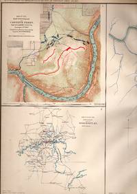
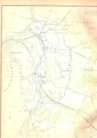
MAP: 3 Section Map, Including Military Reconnaissance Vicinity of Gauley Bridge, Department of Western Virginia; Sketch of the Country About Somerset Kentucky, & Map of the Battlefield of Carnifix Ferry, Gauley River, West Virgiinia
by United States War Department
- Used
- very good
- Paperback
- first
- Condition
- Used - Very Good
- Edition
- First Thus
- Binding
- Paperback
- Quantity Available
- 1
- Seller
-
Hagerstown, Maryland, United States
- Item Price
-
$75.00
Show Details
Description:
Washington, D.C.: Government Printing Office, 1891. Plate #IX (9) from the Atlas to Accompany the Official Records of the Union and Confederate Armies, 1861-1865..single sheet, LOVELY and suitable for framing [2 scans = almost full image]. First Thus. Unbound. Very Good. Illus. by Colored Map. 18" x 29".
Item Price
$75.00

More Photos
MAP:9 Photoengravings on Double Sheet...several Around Nashville, Virginia, and Georgia
by United States War Department
- Used
- very good
- Paperback
- first
- Condition
- Used - Very Good
- Edition
- 1st
- Binding
- Paperback
- Quantity Available
- 1
- Seller
-
Hagerstown, Maryland, United States
- Item Price
-
$75.00
Show Details
Description:
Washington D.C.: Government Printing Office, 1891. 1st printing, thus edition; Plate #CXXIV from the Atlas to Accompany the Official Records of the Union & Confederate Armies, 1861-1865...9 separate views of Confederate encampments, etc, including:CIVIL WAR; Nashville, Tennessee, Fort St. Cloud Hill, Lookout Mountain, Rossville Gap, Georgia, Buzzard Roost Gap, Rocky Face Ridge Gap, Dutch Gap, Virginia, Appomattox River, Broadway, Virginia, Spofford Virginia, Signal Station, Fort Wisconsin, Virginia; Single sheet suitable for framing; repair at corner tip; [2 scans = almost full item]. 1st. Unbound. Very Good. Illus. by Hand Colored Map. 18" x 29".
Item Price
$75.00
More Photos
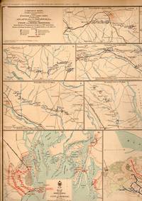
MAP: Campaign Maps: Position of 20th Army Corps on March from Atlantsw, GA to Savannah, GA with dates and Defenses... (18 maps, 1 sheet)
by United States War Department
- Used
- very good
- Paperback
- Condition
- Used - Very Good
- Binding
- Paperback
- Quantity Available
- 1
- Seller
-
Hagerstown, Maryland, United States
- Item Price
-
$75.00
Show Details
Description:
Washington D.C.: Government Printing Office, 1891. Plate LXXI...From the Atlas to Accompany the Official Records of the Union & Confederate Armies, 1861-1865. additional maps: Map of the defenses of the City of Mobile, Alabama, rebel line of works at Blakely, Alabama Expedition from messenger's ferry toward canton, Mississippi & Positon occupied by troops French's division at Chattahoochee river; margins reinforced on reverse, lite chipping......Single sheet suitable for framing [2 scans=almost full image]. Unbound. Very Good. Illus. by Handcolored. 18" x 29".
Item Price
$75.00
More Photos
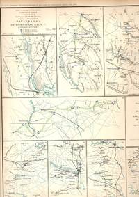
MAP: "Campaign Maps: Savannah,m GA to Goldsborough & Goldsborough to Washington, D.C. & Operations About Bottom's Bridge, VA.".. (17 maps, 1 sheet)
by United States War Department
- Used
- very good
- Paperback
- first
- Condition
- Used - Very Good
- Binding
- Paperback
- Quantity Available
- 1
- Seller
-
Hagerstown, Maryland, United States
- Item Price
-
$75.00
Show Details
Description:
Washington D.C.: Government Printing Office, 1891. Plate LXXXVI...From the Atlas to Accompany the Official Records of the Union & Confederate Armies, 1861-1865. 17 maps, first printing after the Civil War......Single sheet, suitable for framing [2 scans=almost full image]. Unbound. Very Good. Illus. by Handcolored. 18" x 29".
Item Price
$75.00
MAP: Reconnaissance of Yorktown, Virginia area, April, May 1862 (3 maps, 1 sheet)
by United States War Department
- Used
- very good
- Paperback
- Condition
- Used - Very Good
- Binding
- Paperback
- Quantity Available
- 1
- Seller
-
Hagerstown, Maryland, United States
- Item Price
-
$75.00
Show Details
Description:
Washington D.C.: Government Printing Office, 1891. From the Atlas to Accompany the Official Records of the Union & Confederate Armies, 1861-1865....Single sheet suitable for framing. Unbound. Very Good. Illus. by Handcolored. 18" x 29".
Item Price
$75.00
More Photos
MAP: 6 Maps: Defenses of Mason, Georgia; Battlefield of Chancellorsville, VA,; Battle of Cedar Moutain, VA; Battle of Wilson's Green, Missouri, Batttles of Buckingham and Appomattox, VA; Etc
by United States War Department
- Used
- very good
- Paperback
- Condition
- Used - Very Good
- Binding
- Paperback
- Quantity Available
- 1
- Seller
-
Hagerstown, Maryland, United States
- Item Price
-
$75.00
Show Details
Description:
Washington D.C.: Government Printing Office, 1891. Plate CXXXV, From the Atlas to Accompany the Official Records of the Union & Confederate Armies, 1861-1865. ; Lovely, and suitable for framing [2 images captures most of the item]. Unbound. Very Good. Illus. by Colored. 18" x 29".
Item Price
$75.00
More Photos
MAP: 5 Section Map, Including The Chickamauga Campaigh & Approaches and Defenses of Knoxville, Tennessee
by United States War Department
- Used
- very good
- Paperback
- first
- Condition
- Used - Very Good
- Edition
- 1st
- Binding
- Paperback
- Quantity Available
- 1
- Seller
-
Hagerstown, Maryland, United States
- Item Price
-
$75.00
Show Details
Description:
Washington, D.C.: Government Printing Office, 1891. 1st thus printing; Plate #XLVIII from the Atlas to Accompany the Official Records of the Union and Confederate Armies, 1861-1865..single sheet suitable for framing [2 scans = almost a full image of item]. 1st. Unbound. Very Good. Illus. by Colored Map. 18" x 29".
Item Price
$75.00
More Photos
MAP: 4 Section Map, Including Artillery Positions Of the Army of the Potomac, Reconnaissance Beyond the Chickahominy, Petersburg, Virginia
by United States War Department
- Used
- very good
- Paperback
- first
- Condition
- Used - Very Good
- Edition
- 1st
- Binding
- Paperback
- Quantity Available
- 1
- Seller
-
Hagerstown, Maryland, United States
- Item Price
-
$75.00
Show Details
Description:
Washington, D.C.: Government Printing Office, 1891. First Thus printing; Plate #LXIV (64) from the Atlas to Accompany the Official Records of the Union and Confederate Armies, 1861-1865..single sheet suitable for framing [2 scans = almost full image]. 1st. Unbound. Very Good. Illus. by Colored Map. 18" x 29".
Item Price
$75.00