
Click for full-size.
A Map of the British and French Settlements in North America, c. 1755: Scots Magazine, vol. 17, 1755
- Used
- Condition
- See description
- Seller
-
FRAMINGHAM, Massachusetts, United States
Payment Methods Accepted
About This Item
Details:
T[homas] Phinn, engraver
black and white engraving on thin, period 18th c. laid paper, two elaborate watermarks including date "1742" , large decorative cartouche, as found removed by others
dimensions: 15" x 10 7/8
condition: professionally conserved, period folds, some paper loss at one vertical fold, small repaired tear in right margin into map field, paper toned, a good, crisp impression of the map and the English land claims text block, fragile but may be handled
Description:
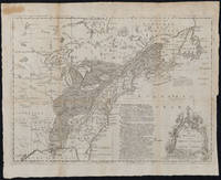
This 18th c. British map is the scarce edition published in Scots Magazine, of 1755, v.17 and presents an early colonial view of North American settlement and the competition between the British and French who at this date were together still a minority population among the established and historic native inhabitants of this large territory. The engraver's name on the print is Thomas Phinn. The Library of Congress curiously identifies this scarce map edition engraver's name as "Phin" with "? Edinburgh" even though the LOC edition of the map also shows the spelling as "Phinn". The paper on which the map is printed appears to have a date of 1742 in the watermark.
T[homas] Phinn, engraver
black and white engraving on thin, period 18th c. laid paper, two elaborate watermarks including date "1742" , large decorative cartouche, as found removed by others
dimensions: 15" x 10 7/8
condition: professionally conserved, period folds, some paper loss at one vertical fold, small repaired tear in right margin into map field, paper toned, a good, crisp impression of the map and the English land claims text block, fragile but may be handled
Description:
This 18th c. British map is the scarce edition published in Scots Magazine, of 1755, v.17 and presents an early colonial view of North American settlement and the competition between the British and French who at this date were together still a minority population among the established and historic native inhabitants of this large territory. The engraver's name on the print is Thomas Phinn. The Library of Congress curiously identifies this scarce map edition engraver's name as "Phin" with "? Edinburgh" even though the LOC edition of the map also shows the spelling as "Phinn". The paper on which the map is printed appears to have a date of 1742 in the watermark.
A Map of the British and French Settlements in North America of c. 1755 is an argument in the format of a map whose graphic elements outline the land claim by the British. There are three primary graphic elements of this medium sized map: the map, a column of text and a tiered trophy-like monument decorated with elaborate flowers bearing the map title. First, the map itself illustrates the territory and the competing settlements to which the map title refers. The map is labeled by place names, topography, native Indian dominions, colonial place names, forts and a record of historical settlements with dates. Next, as if physically supporting the leaning land mass bounded to the east by the Atlantic coast line, a column of dense text in bold italics rises to the mid-point of the map. This column of text lays out in ten paragraphs the "The English Claim to North America". The document establishes British legal authority derived from King Henry VII and from Queen Elizabeth, the "Virgin Queen" whose name Sir Walter Raleigh bestows on his derivative "claim" of Virginia. Newfoundland is credited in 1581 as the first English settlement - possession is nine tenths of the law. From this legal foundation flows a second possession of land in Virginia in "16__" */ where in 1621 the "whole settlement was almost ruined by Natives who massacred 700...". New England's "claim" is also by physical settlement in 1584 by Sir Philip Amadas and Capt. Arthur Barlow. We are told New England was enlarged by the colonies of Plymouth, Connecticut and Massachusetts "and is now the most powerful upon the Continent" words that were prophetic. New Jersey in 1666 was similarly "established" by two English proprietors. New York was "granted" in 1664 to the Duke of York which "was formerly in ye Hands of ye Dutch" a claim rooted in the British monarchy. Pensilvania's title derives from William Penn's Patent of 1680 granted to Penn by the Crown for his fidelity. Maryland was separated out from Virginia in 1631 by fiat of King Charles who "invested the property" in Calvert Lord Baltimore whose patent is dated 1632. Finally, Carolina was "Granted by Patent" to Sir George Carteret in 1665 with seven others, all of whom except Carteret sold their rights to the Crown in 1728. Sir Carteret renamed Lord Granville came to possess 1/8 of the "Propriety bordering on Virginia." Thus, the British claim to North America on our map is proven by Royal authority itself a modified form of divine right. The Magna Carta of 1215 deemed the British Crown not above the law. Hence the map's use of terms for the Crown to issue patents, investment and grants and other Royal documents to legalize these land claims which without physical possession were of little effect.
This map therefore is a view of North America at its point of inflection regarding the relative power of native peoples, and the determined British and French Colonizers. A small paragraph located in the great fishing banks off Nova Scotia offers and "Explanation": "The French Incroachments are Shewn by Oblique Strokes and their forts with two strokes the English forts by a single Stroke." The forts appear so small in this wilderness, riven with a massive north-south mountain range, punctuated with the three great lakes and watered by the powerful St. Lawrence River, more a flowing ocean than a finite flow of water. The map boundaries show the successive dates and changes in the relative colony boundaries westward to the Mississippi River. Some of the Atlantic Islands, such as Bermuda are shown on this map.
The dark slanted lines on this map that overlay half of the sparsely settled lands represent the "French Encroachments" on the English. The English perspective of this map expresses the presumption that the English have a claim to the entire territory of North America east of the Mississippi prior to and as of 1755. Scots Magazine was a forum for political news and debate. The appearance of the Phinn engraved map in Scots Magazine permitted the maps proponents to make their case to like minded readers. In some respects, this map is a piece of advocacy.
Native peoples are identified with great particularity throughout the map. Reading this map is an opportunity to appreciate how well the British had come to know the variety of people in their midst, and the established territories in which the Native Americans lived and operated. The next comparable biography of the lands possessed by Native North Americans may be Pownall's A New Map of North America...Divided According to the Preliminary Articles of Peace, Signed at Versaille 20 Jan. 1783, publ. 1786 (please see www.spackantiquemaps.com).
Therefore this map is not merely a map showing a growing political conflict and the prelude to a war between the British and the French over colonial claims. More significantly from a cultural and historical view of North American, this map brings the reader from a time of Native American settlement of North America before first contact up to one of the most dangerous instances of colonial militarization to defend the early network of coastal land claims asserted as far west as the Mississippi River.
Note
*/ The missing half of the early 17th c. date for the founding of Virginia appears in the John Lodge version of this map, as well as another examples of the Scots Magazine versions of the map. The John Lodge edition of the map is laid out somewhat differently and was bound into the book it illustrated on the left margin. Which map came first? Likely the error was made when copying the same predecessor map plate.
Reviews
(Log in or Create an Account first!)
Details
- Seller
- Original Antique Maps
 (US)
(US)
- Seller's Inventory #
- 440
- Title
- A Map of the British and French Settlements in North America, c. 1755
- Book Condition
- Used
- Quantity Available
- 1
- Date Published
- c.1775
- Weight
- 0.00 lbs
- Keywords
- map, Native Americans, North American colonization, American Indians, North American exploration
Terms of Sale
Original Antique Maps
30 day return guarantee, with full refund including original shipping costs for up to 30 days after delivery if an item arrives misdescribed. If an item arrives damaged, please contact Original Antique Maps immediately to report the damage and discuss whether the original shipping materials may still be used to return the item and for return shipping instructions. Original Antique Maps will fully refund buyer's payments and pay for the return shipping of any damaged item. Buyer will be paid following receipt by Original Antique Maps of the returned item. Otherwise, returns as per www.spackantiquemaps.com.Buyer will be advised of shipping and handling charges that exceed standard charges to buyer.
About the Seller
Original Antique Maps
Biblio member since 2020
FRAMINGHAM, Massachusetts
About Original Antique Maps
Rare and unusual 18th and 19th century Americana, American and International maps, atlases, prints, nautical charts and manuscript maps. My interests include American 19th century newspapers and manuscript materials such as letters. Maps of the 20th c. including advertising, transit and urban planning are of special interest. Original art on paper in its many forms, including posters and field studies for ultimate print publication.
Glossary
Some terminology that may be used in this description includes:
- Text Block
- Most simply the inside pages of a book. More precisely, the block of paper formed by the cut and stacked pages of a book....
- LOC
- Library of Congress
- New
- A new book is a book previously not circulated to a buyer. Although a new book is typically free of any faults or defects, "new"...
- Crisp
- A term often used to indicate a book's new-like condition. Indicates that the hinges are not loosened. A book described as crisp...
- Plate
- Full page illustration or photograph. Plates are printed separately from the text of the book, and bound in at production. I.e.,...

Collect modern first editions
Biblio is showcasing the top book published every year starting in 1919. See if your favorite modern first edition made the list! Check out our collecting first editions by the year.

Collecting and identifying signed letters and holographic documents
Many authors and other famous literary figures wrote and signed letters by hand, and you can find a great collection of them in the Biblio rare book room. See our great collection of handwritten letters and holographic documents