Description:
The Times, London, 1920. First Edition. Softcover. Very Good Condition/No Dust Jacket. Map Disbound single sheet with horizontal centre fold from the 1920 "The Times Survey Atlas of the World". Map is in colour and suitable for framing. Colour on both land and sea according to contour. Map at scale 1:5,000,000. Map covers; Michigan, Indiana, Ohio, Pennsylvania, New York, Maine, Vermont, New Hampshire, Massachusetts, West Virginia, Kentucky, North and South Carolina, Alabama, Georgia, Florida, Nova Scotia, Lake Erie, Lake Ontario, Lake Michigan, Lake Huron, Boston, New York, Philadelphia, Montreal, Ottawa, etc. Sheet contains two inset maps; Niagara Falls and environs and Population Denisity for USA. Slightly darkened edges and occasional light foxing in margins but sheet is otherwise clean and crisp. Item Type: Map. Single sheet map/chart which is suitable for framing and will be shipped rolled and in a cardboard tube. Quantity Available: 1. Shipped Weight: under 1 kg. Pictures of this…
Read More Map of North America from the 1920 Times Survey Atlas (Plate 80) including Dominion of Canada, United States, Greenland, Mexico, West Indies and Central America by The Times and J. G. Bartholomew - 1920
by The Times and J. G. Bartholomew
Similar copies are shown below.
Similar copies are shown to the right.
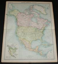
Map of North America from the 1920 Times Survey Atlas (Plate 80) including Dominion of Canada, United States, Greenland, Mexico, West Indies and Central America
by The Times and J. G. Bartholomew
- Used
- Paperback
- first
The Times, London, 1920. First Edition. Softcover. Very Good Condition/No Dust Jacket. Map Disbound single sheet with horizontal centre fold from the 1920 "The Times Survey Atlas of the World". Map is in colour and suitable for framing. Coloured according to country. Map at scale 1:17,000,000. Map covers; USA, Canada, Alaska, Greenland, Mexico, Guatemala, Honduras, Salvador, Nicaragua, Costa Rica, Panama, Bahama Islands, Cuba, Jamaica, Haiti, Porto Rico, Pacific Ocean, Atlantic Ocean, Gulf of Mexico, Arctic Sea, Caribbean Sea, etc. Slightly darkened edges with light foxing in margins but sheet is otherwise clean and crisp. Item Type: Map. Single sheet map/chart which is suitable for framing and will be shipped rolled and in a cardboard tube. Quantity Available: 1. Shipped Weight: under 1 kg. Pictures of this item not already displayed here available upon request. Inventory No: 45020034026..
-
Bookseller
Bailgate Books Ltd
 (GB)
(GB)
- Format/Binding Softcover
- Book Condition Used - Very Good Condition
- Jacket Condition No Dust Jacket
- Quantity Available 1
- Edition First Edition
- Binding Paperback
- Publisher The Times
- Place of Publication London
- Date Published 1920
- Keywords BZDB4 Maps; South & Central America & the West Indies; World History; USA & Canada. The Times and J. G. Bartholomew Map of North America from the 1920 Times Survey Atlas (Plate 80) including Dominion of Canada, United States, Greenland, Mexico
We have 1 copies available starting at $30.41.

More Photos
Map of Eastern Section of United States from the 1920 Times Survey Atlas (Plate 90) including Michigan, Indiana, Ohio, Pennsylvania, New York, Maine, Virginia, Kentucky, North Carolina, Alabama, Georgia, Florida, Niagara Falls etc
by The Times and J. G. Bartholomew
- Used
- Paperback
- first
- Condition
- Used - Very Good Condition
- Jacket Condition
- No Dust Jacket
- Edition
- First Edition
- Binding
- Paperback
- Quantity Available
- 1
- Seller
-
Doncaster, Aberdeen, United Kingdom
- Item Price
-
$30.41
Show Details
Item Price
$30.41