Click for full-size.


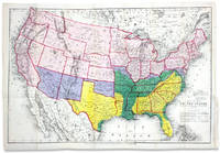
Map of the United States, Showing the Territory in Possession of the Federal Union, January, 1864
by [Bacon & Co., Lithographers]
- Used
- Condition
- See description
- Seller
-
Wilmington, Delaware, United States
Payment Methods Accepted
About This Item
London: Lithographed by Bacon & Co., Map Publishers and Importers of American Maps and Books, [1864]. 27½ x 19 inches. Vibrantly hand-colored. Two closed tear expertly mended on verso with tissue. Housed in archival Mylar sleeve. Very good.
An unusual 1864 Civil War map distinguishing territory controlled by the Federal Union from that remaining in possession of the Confederacy. Together, areas tinted purple, green, and yellow show the claimed territory of the Confederate States at the beginning of the war (basically all the slave states except Delaware), most of it under Confederate military control.
A closer reading of the map's color key, however, reveals a shrinking Confederacy. Green areas emphasize territory reclaimed by the Union, leaving the yellow portion to show the narrowing Rebel remains. Importantly, the reclaimed Union territory includes areas of high slave concentrations, now oases of Black emancipation. These comprise the Virginia Tidewater, the Sea Island coast of South Carolina and Georgia, and the Black Belts of Northeastern Mississippi and along the Mississippi River from Tennessee to New Orleans. A table below the title reporting free and slave populations shows that the number of slaves under Confederate control was reduced by ~38% as of January 1864.
The depiction of the Rocky Mountain territories of the West is notable. Dakota Territory expands through present-day Montana to meet Washington State and "Idao" (so spelled, i.e. Idaho) lacks its upper panhandle and includes today's Wyoming. Other features of the West include the outline of "Indian Territory" (now Oklahoma) and the location and names of multiple forts and military camps there and in central and western Texas (two "Camp Colorados"), New Mexico, and Arizona, all areas formerly claimed as Confederate territory.
Eberstadt: "The special feature which gives outstanding interest to this cartographical production is the inclusion of all that was hereafter to be Wyoming within the boundaries of Idaho, and the naming of that Territory 'IDAO.'" The map was issued with Massie's America: The Origin of her Present Conflict; her Prospect for the Slave, and her Claim for Anti-Slavery Sympathy.... (See Sabin 46185. Coulter 318. Howes M-384. LCP, Afro-Americana 6545.) IB100
Reviews
(Log in or Create an Account first!)
Details
- Seller
- Ian Brabner, Rare Americana (ABAA)
 (US)
(US)
- Seller's Inventory #
- 3731184
- Title
- Map of the United States, Showing the Territory in Possession of the Federal Union, January, 1864
- Author
- [Bacon & Co., Lithographers]
- Book Condition
- Used
- Quantity Available
- 1
Terms of Sale
Ian Brabner, Rare Americana (ABAA)
We are members of the Antiquarian Booksellers Association of America (ABAA) and the International League of Antiquarian Booksellers (ILAB). As such, we abide by their code of ethics and conduct. We are also members of The Manuscript Society and The Ephemera Society of America (Lifetime). Ian Brabner is also a member of The Grolier Club.
All items are unconditionally guaranteed to be as described and authentic. All major defects are noted. Images are not to scale, measurements are given. Returns are accepted for any reason within 12 days of receipt. We accept all major credit cards, PayPal, and check. Institutions and libraries may be billed per their budgetary requirements.
All items are subject to prior sale. Title does not pass to the buyer until the purchase price has been discharged in full.
About the Seller
Ian Brabner, Rare Americana (ABAA)
Biblio member since 2020
Wilmington, Delaware
About Ian Brabner, Rare Americana (ABAA)
Established in 1995, Ian Brabner, Rare Americana buys and sells rare books and manuscripts covering diverse facets of American history.
Our inventory encompasses a broad spectrum of collecting interests, with a special focus on 18th- and 19th-century American history, including African-American history, women's history, and unique or unusual materials documenting the American experience. In our stock, you will also find rare pamphlets, documents, letters and correspondence, journals, diaries, significant archives, as well as original art, graphics, and photographs.
Our inventory encompasses a broad spectrum of collecting interests, with a special focus on 18th- and 19th-century American history, including African-American history, women's history, and unique or unusual materials documenting the American experience. In our stock, you will also find rare pamphlets, documents, letters and correspondence, journals, diaries, significant archives, as well as original art, graphics, and photographs.
This Book’s Categories

What is a first edition?
Even if you’re only peripherally aware of book collecting, you’ve doubtless heard the term, first edition, bandied about but you may still be in the dark as to what makes them such a big deal. Learn about first editions and why collectors value them here.

Collecting the Harlem Renaissance
One of the most influential - and certainly most iconic - cultural revolutions in American history, the Harlem Renaissance offers a compelling repertoire for both seasoned and novice book collectors. We’ve put together a beautiful gallery of high points to help start your collection here.