Description:
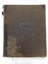
S. Augustus Mitchell, 1864-01-01. Hardcover. Acceptable. **Collated: Of the 59 full page maps called for 31 are missing**; 40 cm. 30 pages of text. The following hand colored maps are present: Nova Scotia; city of Halifax, Canada East, Environs of Montreal; Canada West;, New Hampshire and Vermont; Massachusetts, Connecticut, and Rhode Island; Plan of Philadelphia; Kentucky and Tennessee; North Carolina, South Carolina, Florida; Louisiana, Mississippi, and Arkansas; Ohio and Indiana; Plan of Cincinnati; South America; Venezuela, New Grenada, Guiana; Equador and Peru; Europe; Russia, Norway, Sweden; France, Spain and Portugal; Scotland; Ireland; Austria, Italy, Turkey in Europe, Greece; Prussia and the German Empire; Oceanica; (21 pages of maps only.) **Lacking maps: The World, The World Mercator, North America, United States, Maine, New York, Plan of New York, Plan of Boston, Pennsylvania, Virginia; Georgia and Alabama; Plan of New Orleans; Texas; Illinois; Missouri; Michigan; Kansas; Oregon;…
Read More MITCHELL'S NEW GENERAL ATLAS by Mitchell, Samuel Augustus - 1871
by Mitchell, Samuel Augustus
Similar copies are shown below.
Similar copies are shown to the right.
MITCHELL'S NEW GENERAL ATLAS
by Mitchell, Samuel Augustus
- Used
- Hardcover
Philadelphia: S. Augustus Mitchell, 1871. Hardcover. Folio, unpaginated; VG-; newly rebacked with brown cloth, majority of original front board cloth preserved, including gilt titling; spine with black label, gilt titling; water-damage to upper half of the volume, more pronounced on the first 5 pages, impacts mags, but does not affect coloring; With 67 hand-colored maps (plus insets) on 56 mapsheets (including 9 double-page), plus time table page, reference table, and appendices; shelved above case 2. 1318742. Shelved Dupont Bookstore.
-
Bookseller
Second Story Books, ABAA
 (US)
(US)
- Format/Binding Hardcover
- Book Condition Used
- Quantity Available 1
- Binding Hardcover
- Publisher S. Augustus Mitchell
- Place of Publication Philadelphia
- Date Published 1871
We have 3 copies available starting at $392.00.

More Photos
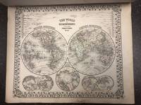
Mitchell's New General Atlas, Containing Maps of the Various Countries of the World, Plans of Cities, Etc. Embraced in Fifty-Three Quarto Maps, Forming a Series of Eighty-four Maps and Plans, Together with valuable Statistical Tables
by Samuel Augustus Mitchell
- Used
- Acceptable
- Hardcover
- Condition
- Used - Acceptable
- Binding
- Hardcover
- Quantity Available
- 1
- Seller
-
Boonsboro, Maryland, United States
- Item Price
-
$392.00
Show Details
Item Price
$392.00
More Photos
Mitchell's New General Atlas, Containing Maps of the Various Countries of the World, Plans of Cities, Etc. Embraced in Fifty-Three Quarto Maps, Forming a Series of Eighty-four Maps and Plans, Together with valuable Statistical Tables
by Samuel Augustus Mitchell
- Used
- good
- Hardcover
- Condition
- Used - Good
- Binding
- Hardcover
- Quantity Available
- 1
- Seller
-
Boonsboro, Maryland, United States
- Item Price
-
$1,470.00
Show Details
Description:
S. Augustus Mitchell, 1864-01-01. Hardcover. Good. Collated, complete. [30] pages, [59] leaves) : 84 color maps ; 40 cm. Publisher's brown boards. Gold lettering on front. Light discoloration to front cover. Contemporary signature of Reo.(sp?) J. L. Jenkins on fep. Maps in good condition. Mitchells New General Atlas was a classic geographical reference in the late 19th century. Taking over the Mitchell Company business after his father retired in 1860, S. Augustus Mitchell, Jr. revised the existing Mitchell atlas and renamed it the New General Atlas. New editions were published yearly until 1887. The maps were so popular they were used by the public and sometimes other publishers until the beginning of the 1900s. See Ristow, American Maps and Mapmakers.
Item Price
$1,470.00

Mitchell's New General Atlas...
by MITCHELL, S[amuel] Augustus Jr
- Used
- Hardcover
- Condition
- Used
- Edition
- Fifty of the maps (3 double-page, 15 inset) are devoted to Cana
- Binding
- Hardcover
- Quantity Available
- 1
- Seller
-
Toronto, Ontario, Canada
- Item Price
-
$1,500.00
Show Details
Description:
Philadelphia: S. Augustus Mitchell & New York: J.W.Willson, 1867. Fifty of the maps (3 double-page, 15 inset) are devoted to Canada and the United States. Included are full-page plans of the cities of Boston, New York City, Philadelphia, Baltimore, Washington, New Orleans, Cincinnati & Chicago. cfPhillips, Atlases, 3558. folio. [ff. 17]. 91 hand-coloured lithographed maps & plans with decorative borders on 58 sheets (5 double-page). 1 hand-coloured time-table on verso of double-hemisphere map. original half calf over blind & gilt-stamped cloth (binding worn & calf oxidized, covers detached, the maps themselves in very good condition). elala5456
Item Price
$1,500.00