
Click for full-size.
A New Description of Carolina: Speed's Map of Carolina
by SPEED, John
- Used
- Condition
- See description
- Seller
-
London, United Kingdom
Payment Methods Accepted
About This Item
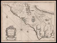
[London],: Thomas Bassett and Richard Chiswell,, [1676].. 380 by 505mm. (15 by 20 inches). Sheet size 408 by 530mm (19 x 21 inches).. Engraved map with text on verso. A fine and attractive map of the Carolina colony. Publishers Thomas Bassett and Richard Chiswell republished English cartographer John Speed's (1552-1629) popular 1611 atlas, "The Theatre of the Empire of Great Britain," in 1676. As a supplement, they included new section, "A Prospect of the most Famous parts of the World," which contained maps engraved by Francis Lamb of the English colonies of New England and New York, Virginia and Maryland, Carolina and Florida, and Jamaica and Barbados. This map depicts the Carolina colony in 1676 drawing from the Lord Proprietor's Map by royal geographer John Ogilby and the explorations of John Lederer (fl. 1670-1675). The map orients the West to the top and depicts the coastline from Cape Charles at the mouth of the Chesapeake Bay to the north and St Augustine, Florida to the south. Looking inland, the Appalachian Mountains, marked as "Apalathean Mountains", cut across the top right section of the map. The present map features a cartouche where the Ogilby publication had an inset map of the Ashley and Cooper Rivers. This map is one of the first to name Charleston ("Charles Town") on the banks of the Ashley River. The map correctly identifies the town on the south bank of the Ashley River, whereas Speed's smaller format map of Carolina incorrectly places the town on the north banks of the river. King Charles II granted eight Lord Proprietors land in North America that extended between 31 and 36 degrees latitude (later extended to 29 degrees). Lederer was a German explorer who travelled West from the East coast of Virginia in hopes of finding the Pacific and the "Sea of China" with its associated riches. He never did reach the Pacific - unsurprisingly - but his personal records of his travels influenced contemporary maps. His description of the "Arenosa Desert" reflects Lederer's memory of crossing the Carolina pine barrens in the blistering summer heat. The "Great Lake" is likely the Catawba flooded, which he mistook as permanent. In total, Lederer traipsed across Virginia and the Eastern coast three times making it as far as the Blue Ridge mountains. Lederer's discoveries are recorded in Sir William Talbot's translation of the explorer's account from Latin to English and published in London in 1672 as "The Discoveries of John Lederer in three several Marches from Virginia, To the West of Carolina." On the verso the text describes Lederer's journeys and discoveries. Burden 457, Cumming 77
Reviews
(Log in or Create an Account first!)
Details
- Bookseller
- Daniel Crouch Rare Books Ltd
 (GB)
(GB)
- Bookseller's Inventory #
- 15098
- Title
- A New Description of Carolina
- Author
- SPEED, John
- Book Condition
- Used
- Publisher
- Thomas Bassett and Richard Chiswell,
- Place of Publication
- [London],
- Date Published
- [1676].
- Keywords
- Carolina, North Carolina, South Carolina, Charleston, John Speed
- Product_type
- Maps
- Size
- 380 by 505mm. (15 by 20 inches). Sheet size 408 by 530mm (19 x 21 inches).
Terms of Sale
Daniel Crouch Rare Books Ltd
Any item may be returned if you are not happy with it providing we are notified within 7 days of your receiving it. This does not affect any statutory rights you may have under UK or EU law for returning the item outside this period. All we ask is that you return the item(s) by the same or similar method to that in which they were sent to you. Your postage costs and any payment already received will be refunded immediately on our receipt of the items in the same condition as you received them.
About the Seller
Daniel Crouch Rare Books Ltd
Biblio member since 2018
London
About Daniel Crouch Rare Books Ltd
Daniel Crouch Rare Books is specialist dealer in antique atlases, maps, plans, sea charts and voyages dating from the fifteenth to the nineteenth centuries. Our carefully selected stock also includes a number of fine prints and globes, and a selection of cartographic reference books.Our particular passions include rare atlases, wall maps, and separately published maps and charts. We strive to acquire unusual and quirky maps that are in fine condition. We are members of the following trade associations: The Antiquarian Bookseller's Association (ABA); The British Antique Dealers' Association (BADA); Confédération Internationale des Négociantes en Oeuvres d'Art (CINOA); The International League of Antiquarian Booksellers (ILAB); The Society of London Art Dealers (SLAD); and The European Fine Art Foundation (TEFAF). Daniel and Nick are also both members of The Company of Art Scholars, Dealers, and Collectors.
Glossary
Some terminology that may be used in this description includes:
- Verso
- The page bound on the left side of a book, opposite to the recto page.
- New
- A new book is a book previously not circulated to a buyer. Although a new book is typically free of any faults or defects, "new"...
- Fine
- A book in fine condition exhibits no flaws. A fine condition book closely approaches As New condition, but may lack the...

Collecting Banned & Challenged Books
Build a revolutionary library of literature that has been challenged or even outright banned. You’ll be surprised by some of the titles in this gallery!

Browse rare books
Interested in rare and collectible books? Booksellers from around the world showcase some of their finest in Biblio’s rare book room.