Description:
Paperback. Very Good.
A New Plan of the Island of Grenada, from the Original French Survey of Monsieur Pinel Taken in 1763 by Order of Government and Now Published with the Addition of English names, Alterations of Property and Other Improvements to the Present Year 1780... by FADEN, William (1749-1836) - 1780
by FADEN, William (1749-1836)

A New Plan of the Island of Grenada, from the Original French Survey of Monsieur Pinel Taken in 1763 by Order of Government and Now Published with the Addition of English names, Alterations of Property and Other Improvements to the Present Year 1780...
by FADEN, William (1749-1836)
- Used
- first
London: By William Faden, 1780. Fine folding engraved map (32 ¼ x 24 inches). Laid down on cartographic linen in 20 sections, showing the island of Grenada in detail, the title and key upper left, dedication to Lieut. General Robert Melvill lower right, scale center along bottom edge, decorated with a large compass rose, with original hand coloring in outline (a bit thumbed). Provenance: Manuscript title and ownership inscription of Hugh Percy, 2nd Duke of Northumberland (1742-1817) on verso. WONDERFUL MAP OF GRENADA FROM LIBRARY OF HUGH PERCY, 2ND DUKE OF NORTHUMBERLAND, BRITISH OFFICER IN THE AMERICAN REVOLUTION First edition. This large-format, very detailed map includes all landholdings, elevation, and water courses, as well as all the main towns, cities, and ports of Grenada. The key includes symbols for "Sugar Mills drove by Water," "Sugar Mills drove by Cattle," "Great Coffee or Cocoa Plantations," "Small Ditto," and "Pottery or Tile Kilns." Partner of Thomas Jeffreys, London's leading mid-18th century engraver, William Faden assumed sole control of the business after his colleague's death and continued Jeffreys's tradition of producing the finest quality engraved maps and atlases. Faden's fine engravings, in fact, made him one of the greatest cartographers of the 18th century. Faden's talent for mapmaking was such that he was named official geographer to the king in 1775, just five years before he produced this map. Hugh Percy, 2nd Duke of Northumberland, was a British peer and politician, and an officer in the British army during the American Revolution: "In 1763 and again at the 1768 general election, Percy was elected, unopposed, an MP for Westminster. In the Commons he supported the Grenville ministry, and in February 1766 he voted against the repeal of the Stamp Act...[Percy] departed with his regiment in May 1774 for service in North America. He watched with increasing dismay as the situation deteriorated in New England: 'this Country', he told his father on 12 September, 'is now in as open state of Rebellion as Scotland was in the year 45' (Percy papers, vol. L, pt A, fol. 16). When at length hostilities began at Lexington and Concord on 19 April 1775 Percy played a crucial role in saving Lieutenant-Colonel Smith's force from destruction as it retreated to Boston. Percy's brigade, together with two field pieces, met Smith's beleaguered column on the road between Menotomy and Lexington. Percy's troops held the enraged Massachusetts militiamen at bay while Smith's men regrouped, and then escorted Smith's battered command back to Boston under heavy fire. His coolness was widely praised, and he became the hero of the hour in besieged Boston. In July 1775 he was appointed major-general in America, and in September major-general in the army. "In 1776 Percy was involved in the campaign in and around New York. After the British victory on Long Island (27 August 1776) he wrote that the Americans 'will never again stand before us in the Field. Things seem to be over with Them & I flatter myself now that this Campaign will put a total End to the War' (Letters, 69)-a misjudgement, but one shared by many of his colleagues. He took part in the storming of Fort Washington on 16 November 1776, and at the beginning of December he went with General Clinton on the expedition to occupy Newport, Rhode Island. In January 1777 Clinton left Rhode Island for England, leaving Percy in charge of the garrison. "Over the next few weeks Percy's relationship with General Sir William Howe (1729-1814), the British commander-in-chief in America, rapidly deteriorated. Percy complained at Howe's decision to reduce the number of troops under his command in order to reinforce the army operating in New Jersey. He was further aggrieved when Howe pressed him to send a large quantity of forage to New York, which Percy believed could not be spared. When Howe criticized a civil appointment that Percy had made on Rhode Island, then reversed the decision of a court martial over which Percy had presided, and finally implied that he should have taken Providence as well as Newport in the preceding December, Percy decided that he would not allow himself to be 'subject to another such indignity' (Willcox, 127-8). Howe, for his part, regarded Percy as over-sensitive and too status-conscious: 'he thinks I have not treated him according to his rank as an Offr. & Heir apparent to ye Dukedom of Northumberland' (Howe to General James Grant, 18 March 1777, Macpherson Grant papers, bundle 252). Percy returned to England on 5 May, his departure lamented by both the army and the civilian population of Rhode Island, where his humanity and concern for the inhabitants earned him much popularity. Ostensibly, he left America to inherit the Percy barony from his mother, but the real reason for his return home was soon widely known. "Back in England, Percy was promoted in August 1777 lieutenant-general, but he played no further active part in military operations during the American war. In November 1784 he was appointed colonel of the second troop of Horse Grenadier Guards. He inherited his father's dukedom in June 1786, and was lord lieutenant and vice-admiral of Northumberland in 1786-99 and 1802-17. He was promoted general in October 1793, and was colonel of the Royal Horse Guards from December 1806 to 1812...Percy died of rheumatic gout...on 10 July 1817" (Stephen Conway for DNB). His illegitimate brother, James Smithson, was the founding donor of the Smithsonian Institution, despite never having visited the United States. Robert Melvill (1723-1809) was a Scottish soldier, botanist, and inventor who served as acting governor of Grenada 1764, and again in 1770-71. Daniel Paterson (1739-1825) was a British army officer and cartographer, best known for his road-map books, as well as "A Topographical Description of the Island of Grenada" (1780). An attractive copy of a large and detailed map of Grenada, with a distinctive provenance..
-
Bookseller
Arader Galleries
 (US)
(US)
- Book Condition Used
- Publisher By William Faden
- Place of Publication London
- Date Published 1780

Faden's Map of Norfolk
by Faden, William
- Used
- very good
- Paperback
- Condition
- Used - Very Good
- Binding
- Paperback
- ISBN 10 / ISBN 13
- 9780948400094 / 0948400099
- Quantity Available
- 2
- Seller
-
GORING BY SEA, West Sussex, United Kingdom
- Item Price
-
$12.68
Show Details
Item Price
$12.68

Stock Photo: Cover May Be Different
The Maritime Campaign Of 1778: A Collection Of All The Papers Relative To The Operations Of The English And French Fleets : To Which Are Added, ... The Ministry, Concerning The Engagement On..
by John Matthews (R.N.), William Faden
- Used
- good
- Paperback
- Condition
- Used - Good
- Binding
- Paperback
- ISBN 10 / ISBN 13
- 9781279844533 / 1279844531
- Quantity Available
- 1
- Seller
-
HOUSTON, Texas, United States
- Item Price
-
$26.45
Show Details
Description:
Nabu Press, 2012-04-09. Paperback. Good.
Item Price
$26.45

Stock Photo: Cover May Be Different
Atlas Minimus Universalis, or, A Geographical Abridgement Ancient and Modern of the Several Parts of the Earth: in Fifty-five Maps Composed Principally for the Use of Schools, &c
by William 1749-1836 Faden
- New
- Paperback
- Condition
- New
- Binding
- Paperback
- ISBN 10 / ISBN 13
- 9781014675781 / 1014675782
- Quantity Available
- 10
- Seller
-
Southport, Merseyside, United Kingdom
- Item Price
-
$19.01
Show Details
Description:
Paperback / softback. New.
Item Price
$19.01

Faden's Map of Norfolk
by William Faden
- Used
- good
- Paperback
- Condition
- Used - Good
- Binding
- Paperback
- ISBN 10 / ISBN 13
- 9780948400094 / 0948400099
- Quantity Available
- 1
- Seller
-
Wellington, Auckland, New Zealand
- Item Price
-
$9.14
Show Details
Description:
UK: Lark's Press. Good. Paperback. 1989. 54 pages. .
Item Price
$9.14
Stock Photo: Cover May Be Different
Atlas Minimus Universalis, or, A Geographical Abridgement Ancient and Modern of the Several Parts of the Earth: in Fifty-five Maps Composed Principally for the Use of Schools, &c
by William 1749-1836 Faden
- New
- Paperback
- Condition
- New
- Binding
- Paperback
- ISBN 10 / ISBN 13
- 9781014675781 / 1014675782
- Quantity Available
- 10
- Seller
-
Southport, Merseyside, United Kingdom
- Item Price
-
$23.51
Show Details
Description:
Paperback / softback. New.
Item Price
$23.51

Pennsylvania Review: Spring 1967, Volume 1, No. 2
by (BAUM, Philip S., Charles Steiner, William Coleman, Barbara Faden, Charles Steiner, Oreste D'Arconte, Richard Cooper, Dr. Emily Wallace) MANGIONE, Jerre, faculty advisor
- Used
- very good
- Signed
- first
- Condition
- Used - Very Good
- Quantity Available
- 1
- Seller
-
Gloucester City, New Jersey, United States
- Item Price
-
$75.00
Show Details
Description:
Philadelphia: Pennsylvania Review, University of Pennsylvania, 1967. Softcover. Very Good. First edition. Illustrated. Stapled wrappers. 53pp. Bottom corner creased and flared, spine tanned, very good. Inscribed by Jerre Mangione to poet Daniel Hoffman on the front wrapper. "A Conversation with William Styron." "Ezra Pound and William Carlos Williams at Penn" by Emily Wallace. Contributions by Philip S. Baum, Charles Steiner, William Coleman, Barbara Faden, Charles Steiner, Oreste D'Arconte, Richard Cooper, Dr. Emily Wallace.
Item Price
$75.00

More Photos
A Map Of The Austrian Possessions In The Netherlands Or Low Countries With The Principalities Of Liege And Stavelo, &C. Reduced From The Trigonomic Survey Made By The Order Of H.R.H. The Prince Charles Of Lorraine
by Faden, William
- Used
- Condition
- Used
- Quantity Available
- 1
- Seller
-
Port Hope, Ontario, Canada
- Item Price
-
$145.00
Show Details
Description:
Published in Faden's New General Atlas, 1811, 1794. 28" x 21"- 71.1 x 53.3 cm. Copper engraved map with old hand colouring. Offsetting to the North Sea, two short tears to right margin extending just past neatline, dampstain to lower margin, on the whole very good. A very detailed double page map showing the Netherlands, Flanders, parts of France, Luxembourg and Germany. Cf Phillips 6010, 6013, 6047.
William Faden was a prominent Scottish mapmaker (he dropped the "Mac" from his name when he moved to London), Royal Geographer to King George III and publisher during the late 19th and early 19th Centuries. He produced one of the finest set of maps during the American Revolution, as well as producing detailed charts from around the world.
Item Price
$145.00

Chorographical Map of the Kingdom of Portugal Divided into it's Grand Provinces
by FADEN, William
- Used
- very good
- Condition
- Used - very good
- Quantity Available
- 1
- Seller
-
New York, New York, United States
- Item Price
-
$200.00
Show Details
Description:
London: William Faden, 1797. unbound. very good. Map. Engraving with original hand coloring. Image measures 29" x 20".<br/><br/> Beautiful topographical details. Minor aging around edges.<br/><br/>
Item Price
$200.00
More Photos
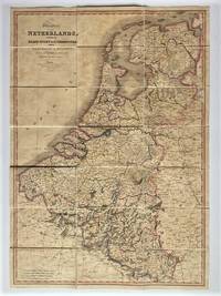
Kingdom of the Netherlands, Including the Grand Duchy of Luxembourg, with the Post Roads and Stations, Likewise the Limits as Settled by the Treaty of Paris, Nov. 20th,1815
by William Faden
- Used
- Condition
- Used - Vg
- Quantity Available
- 1
- Seller
-
Victoria, British Columbia, Canada
- Item Price
-
$195.00
Show Details
Description:
Charing Cross, London: William Faden, Royal Geographer to King George III, 1820. Single Sheet / Folded Map. Vg. Single, linen backed, dissected colour map of the Netherlands - 32 x 22.5 inches folding into 21 panels. Engraved by Neele and Son and published by William Faden (1749-1836) English cartographer and publisher. Excellent overall with light age toning. No tears or holes along the edges or seams. No slipcase available. Inquiries welcome.
Item Price
$195.00
More Photos
Map of the Kingdom of Hanover, with the Grand Duchy of Oldenburg, the Pricipalities of Lippe Detmold and Schauenburg Lippe, likewise the Territories of the Free Towns of Bremen, Hamburg and Lubeck, Conformably with the Treaty of Paris, 1815.
by William Faden
- Used
- Condition
- Used - Vg
- Quantity Available
- 1
- Seller
-
Victoria, British Columbia, Canada
- Item Price
-
$195.00
Show Details
Description:
Charing Cross, London: William Faden, Royal Geographer to King George III, 1819. Antique Map. Vg. Single, linen backed, dissected, colour map, 28 X 23 inches (71 X 58cm) folding into 20 panels. Unmarked, but likely engraved by Neele & Son as with the previous map listed. No tears or holes along the edges or seams, but affected by foxing / age toning, more obvious on the back of the map. Slipcase unavailable. Addition photos available if requested.
Item Price
$195.00