Click for full-size.


The Oarsman's and Angler's Map of the River Thames
by [Thames; Fishing Map] Ravenstein, E. G
- Used
- Hardcover
- Condition
- Very good overall
- Seller
-
Garrison, New York, United States
Payment Methods Accepted
About This Item
London: James Reynolds,174, Strand, 1881. Very good overall. A long folding map of the Thames River, extending from Thames Head, down to the London Bridge, showing towns and villages along the river with historical and descriptive information, details of the locks and bridges, railroad lines near the river, toll charges and angling laws, the species of fish to be caught at each site, and a list describing fishing preserves, "as arranged by the Lord Mayor".
One of the descriptions describes the beauty of the spot: "The Thames at Pangbourne has long been a favorite resort of the angler intent on perch fishing. The scenery in this neighbourhood is very beautiful; the hills are high and healthful, and command extensive views".
Accompanied by the loosely inserted printed "Introductory Notes" sheet which describes boating, angling, the prohibition of netting, undersized fish, fence months and river keepers. Yellow paste down at front. Introductory notes sometimes appear pasted down to the front board, in this case loosely inserted. Dating is inconclusive, this map could be between 1870 and 1880.
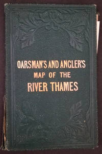
Original color on the river, the map backed onto linen, folds into original blind stamped green cloth covers, gilt title on upper cover.
95 x 6 in, folded in cover 4 1/4 x 6 3/4". Bookseller label of Murray, Frank, Bookseller, Moray House, Derby. Cloth slightly rubbed at spine, two inch closed split along spine and front board, otherwise bright. OCLC: 56771266.
One of the descriptions describes the beauty of the spot: "The Thames at Pangbourne has long been a favorite resort of the angler intent on perch fishing. The scenery in this neighbourhood is very beautiful; the hills are high and healthful, and command extensive views".
Accompanied by the loosely inserted printed "Introductory Notes" sheet which describes boating, angling, the prohibition of netting, undersized fish, fence months and river keepers. Yellow paste down at front. Introductory notes sometimes appear pasted down to the front board, in this case loosely inserted. Dating is inconclusive, this map could be between 1870 and 1880.
Original color on the river, the map backed onto linen, folds into original blind stamped green cloth covers, gilt title on upper cover.
95 x 6 in, folded in cover 4 1/4 x 6 3/4". Bookseller label of Murray, Frank, Bookseller, Moray House, Derby. Cloth slightly rubbed at spine, two inch closed split along spine and front board, otherwise bright. OCLC: 56771266.
Reviews
(Log in or Create an Account first!)
Details
- Bookseller
- Antipodean Books, Maps & Prints
 (US)
(US)
- Bookseller's Inventory #
- 23661
- Title
- The Oarsman's and Angler's Map of the River Thames
- Author
- [Thames; Fishing Map] Ravenstein, E. G
- Book Condition
- Used - Very good overall
- Quantity Available
- 1
- Binding
- Hardcover
- Publisher
- James Reynolds,174, Strand
- Place of Publication
- London
- Date Published
- 1881
- Bookseller catalogs
- MAPS;
Terms of Sale
Antipodean Books, Maps & Prints
30 day return guarantee, with full refund including shipping costs for up to 10 days after delivery if an item arrives mis-described or damaged.
About the Seller
Antipodean Books, Maps & Prints
Biblio member since 2009
Garrison, New York
About Antipodean Books, Maps & Prints
Booksellers for over 40 years, members of prominent trade associations (ABAA, ILAB, ANZAAB, IMCOS, ANZMS, PBFA). We are located at Garrison NY, a stone's throw from the Metro North Hudson line train, just over 1 hr. from NYC on the banks of the Hudson River. Books, maps, prints & ephemera bought & sold.
Glossary
Some terminology that may be used in this description includes:
- Spine
- The outer portion of a book which covers the actual binding. The spine usually faces outward when a book is placed on a shelf....
- Gilt
- The decorative application of gold or gold coloring to a portion of a book on the spine, edges of the text block, or an inlay in...
- Cloth
- "Cloth-bound" generally refers to a hardcover book with cloth covering the outside of the book covers. The cloth is stretched...
This Book’s Categories

Signed Books
Why settle for an ordinary copy of your favorite book when you could have an autographed copy? Find signed books here.

Collecting Miniature Books
Teeny, tiny, beautiful books...the world of miniature books is one that involves a lot of imagination and craftsmanship. Dive in and see!