Description:
Arrested hand coloring in outline. Some soiling. Ghosting to rear. Ink notes to rear. See image.; Small 4to 9" - 11" tall; All shipments through USPS insured Priority Mail.
Outlines of the Physical and Political Divisions of South America, Delineated by Aaron Arrowsmith; Samuel Lewis - 1811
by Aaron Arrowsmith; Samuel Lewis
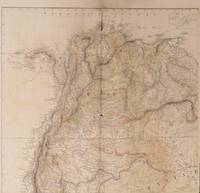
Outlines of the Physical and Political Divisions of South America, Delineated
by Aaron Arrowsmith; Samuel Lewis
- Used
- first
Six large sheets to be joined together for complete 94.5 x 78.5 inch map of South America. Separations at fold lines and tape to edge of paper at fold lines; transfers and localized foxing. Hand-colored in outline.
-
Seller
William Chrisant & Sons' Florida Book Shop, ABAA, ILAB, FABA
 (US)
(US)
- Book Condition Used
- Quantity Available 1
- Edition First Edition
- Place of Publication London
- Date Published 1811
![[Map of] Scotland](https://d3525k1ryd2155.cloudfront.net/h/487/759/1036759487.0.m.jpg)
[Map of] Scotland
by Aaron Arrowsmith; Samuel Lewis
- Used
- very good
- Condition
- Used - Very Good
- Quantity Available
- 1
- Seller
-
Fort Lauderdale, Florida, United States
- Item Price
-
$80.00
Show Details
Item Price
$80.00
![[Map of] Italy](https://d3525k1ryd2155.cloudfront.net/h/489/759/1036759489.0.m.jpg)
[Map of] Italy
by Aaron Arrowsmith; Samuel Lewis
- Used
- very good
- Condition
- Used - Very Good
- Quantity Available
- 1
- Seller
-
Fort Lauderdale, Florida, United States
- Item Price
-
$100.00
Show Details
Description:
Original (not later) hand-color in outline. Foxing to seas (see image). ; Small 4to 9" - 11" tall; All shipments through USPS insured Priority Mail. .
Item Price
$100.00

Map of Virginia From a New and Elegant General Atlas; Comprising all the New Discoveries, to the Present Time
by Aaron Arrowsmith; Samuel Lewis
- Used
- very good
- Condition
- Used - Very Good
- Quantity Available
- 1
- Seller
-
Fort Lauderdale, Florida, United States
- Item Price
-
$150.00
Show Details
Description:
Map. Original early nineteenth century Virginia with counties delineated. Ghosting from adjoining map. Slight stains and foxing. See image.10.75 x 8.75 in
Item Price
$150.00

Map of South Carolina From a New and Elegant General Atlas; Comprising all the New Discoveries, to the Present Time
by Aaron Arrowsmith; Samuel Lewis
- Used
- very good
- Condition
- Used - Very Good
- Quantity Available
- 1
- Seller
-
Fort Lauderdale, Florida, United States
- Item Price
-
$150.00
Show Details
Description:
Map. Original early nineteenth century outline with counties delineated. Ghosting from adjoining map. Slight stains and foxing. See image. 10.75 x 8.75 in
Item Price
$150.00
![[Map of] France](https://d3525k1ryd2155.cloudfront.net/h/478/759/1036759478.0.m.jpg)
[Map of] France
by Aaron Arrowsmith; Samuel Lewis
- Used
- very good
- Condition
- Used - Very Good
- Quantity Available
- 1
- Seller
-
Fort Lauderdale, Florida, United States
- Item Price
-
$185.00
Show Details
Description:
Original early nineteenth century hand-color in outline. Moisture mark to top border. Slight foxing. See image.; Small 4to 9" - 11" tall; All shipments through USPS insured Priority Mail.
Item Price
$185.00

Vermont
by Lewis, Samuel - Arrowsmith, Aaron
- Used
- Condition
- Used - Excellent
- Quantity Available
- 1
- Seller
-
Toronto, Ontario, Canada
- Item Price
-
$175.00
Show Details
Description:
Philadelphia: John Conrad & Co, 1804. Excellent. Size : 270x225 (mm), 10.625x8.875 (Inches), Coloring: Hand Colored, Category: Maps United States New England (States);
Item Price
$175.00

Rhode Island
by Lewis, Samuel - Arrowsmith, Aaron
- Used
- very good
- Condition
- Used - Very Good
- Quantity Available
- 1
- Seller
-
Toronto, Ontario, Canada
- Item Price
-
$175.00
Show Details
Description:
Philadelphia: John Conrad & Co, 1804. Very Good. Size : 272x220 (mm), 10.75x8.625 (Inches), Coloring: Hand Colored, Category: Maps United States New England (States);
Item Price
$175.00
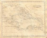
Map of the West Indies
by Aaron Arrowsmith; Samuel Lewis
- Used
- Fine
- Condition
- Used - Fine
- Quantity Available
- 1
- Seller
-
Fort Lauderdale, Florida, United States
- Item Price
-
$200.00
Show Details
Description:
Map. Original early nineteenth century outline of the West Indies and the southern United States. Minor ghosting from adjoining map. Slight stains and foxing. See image. Scarce.10.5 x 8.75 in
Item Price
$200.00
![[Map of] Sweden and Norway](https://d3525k1ryd2155.cloudfront.net/h/491/759/1036759491.0.m.jpg)
[Map of] Sweden and Norway
by Aaron Arrowsmith; Samuel Lewis
- Used
- very good
- Condition
- Used - Very Good
- Quantity Available
- 1
- Seller
-
Fort Lauderdale, Florida, United States
- Item Price
-
$200.00
Show Details
Description:
Original early nineteenth century hand-color in outline. See image.; Small 4to 9" - 11" tall; All shipments through USPS insured Priority Mail.
Item Price
$200.00
![[Map of] Maryland](https://d3525k1ryd2155.cloudfront.net/h/776/702/1037702776.0.m.jpg)
[Map of] Maryland
by Aaron Arrowsmith; Samuel Lewis
- Used
- very good
- Condition
- Used - Very Good
- Quantity Available
- 1
- Seller
-
Fort Lauderdale, Florida, United States
- Item Price
-
$220.00
Show Details
Description:
Original early nineteenth century hand-color in outline with counties delineated. Moisture mark to bottom left quarter and bottom right corner. Foxing & staining (see image).; c. 8 3/8 x 10 1/2 inches; All shipments through USPS insured Priority Mail.
Item Price
$220.00