Description:
New. New Book; Fast Shipping from UK; Not signed; Not First Edition; The Geography of the British Colonies and Foreign Possessions. Designed as a handbook to Philips' Atlas of the British Empire. Fifth edition enlarged..
PHILIPS' ATLAS OF BRITAIN & THE WORLD -
Similar copies are shown below.
Similar copies are shown to the right.

PHILIPS' ATLAS OF BRITAIN & THE WORLD
- Used
- Hardcover
Published by Guild Publishing, 1989. Hardback. Nearly Fine/Nearly Fine. Nearly fine condition in a nearly fine dustwrapper. Large format.
-
Bookseller
Stella & Rose's Books
 (GB)
(GB)
- Format/Binding Hardback
- Book Condition Used - Nearly Fine
- Jacket Condition Nearly Fine
- Binding Hardcover
- Publisher Published by Guild Publishing
- Date Published 1989
- Keywords TOPOGRAPHY (UK GENERAL) TOPOGRAPHY (FOREIGN) ATLAS
We have 5 copies available starting at $27.35.

Stock Photo: Cover May Be Different
Geography of the British Colonies and Foreign Possessions. Designed as a handbook to Philips' Atlas of the British Empire. Fifth edition enlarged.
by John Pincher Faunthorpe
- New
- Condition
- New
- ISBN 10 / ISBN 13
- 9781240906765 / 1240906765
- Quantity Available
- 768
- Seller
-
Uxbridge, Greater London, United Kingdom
- Item Price
-
$27.35
Show Details
Item Price
$27.35
Stock Photo: Cover May Be Different
Geography of the British Colonies and Foreign Possessions. Designed as a handbook to Philips' Atlas of the British Empire. Fifth edition enlarged
by John Pincher Faunthorpe
- Used
- good
- Paperback
- Condition
- Used - Good
- Binding
- Paperback
- ISBN 10 / ISBN 13
- 9781240906765 / 1240906765
- Quantity Available
- 1
- Seller
-
HOUSTON, Texas, United States
- Item Price
-
$37.38
Show Details
Description:
British Library, Historical Print Editions, 2011-01-10. Paperback. Good.
Item Price
$37.38

Geography of the British Colonies and Foreign Possessions. Designed as a Handbook to Philips' Atlas of the British Empire. Fifth Edition Enlarged.
by John Pincher Faunthorpe
- New
- Paperback
- Condition
- New
- Binding
- Paperback
- ISBN 10 / ISBN 13
- 9781240906765 / 1240906765
- Quantity Available
- 10
- Seller
-
Southport, Merseyside, United Kingdom
- Item Price
-
$31.45
Show Details
Description:
Paperback / softback. New.
Item Price
$31.45
Stock Photo: Cover May Be Different
Geography of the British Colonies and Foreign Possessions. Designed as a handbook to Philips' Atlas of the British Empire. Fifth edition enlarged
by Faunthorpe, John Pincher
- New
- Paperback
- Condition
- New
- Binding
- Paperback
- ISBN 10 / ISBN 13
- 9781240906765 / 1240906765
- Quantity Available
- 5
- Seller
-
campbelltown, Florida, United States
- Item Price
-
$33.00
Show Details
Description:
British Library, Historical Print Editions. paperback. New. 7x0x9. Brand New Book in Publishers original Sealing
Item Price
$33.00
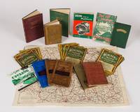
Collection of British Cycling and Touring Books and Maps. 1: J.G. Bartholomew, The Handy Touring Atlas of the British Isles / 2: Alexander Gross and F. Waite-Browne, The Premier Road Book of Great Britain / 3: 'Cycles and Mopeds, Cycling Books of Maintenance / 4: Cycling Touring Club's 'Cycling' [Know the Game Series] / 5: Cyclists' Touring Club, 'C.T.C. Handbook and Guide' / 6: The Kuklos Annual and Handbook for Cyclists and other Roadfarers, 1925 / 7: Harold Briercliffe, Northern England / 8: Harold Briercliffe, Southern England, / 9: Philips New Series of County Maps - Surrey / 10: Bartholomew's Reduced Survey Map of Dorset / 11: Bartholomew's Reduced Survey Map of South Devon / 12: Bartholomew's Reduced Survey Map of York and Scarborough / 13: 'Cycling Map of the Midlands' published by E.J. Larby / 14: Wincarins Motor & Cyclist Map of England (in Sixteen Sections)
by [Cycling in Great Britain]
- Used
- Hardcover
- Condition
- Used
- Binding
- Hardcover
- Quantity Available
- 1
- Seller
-
Skibbereen, Ireland
- Item Price
-
$705.64
Show Details
Description:
1923. 14 volumes - 8 books, 4 Leporellos and 2 large fold-out maps. London, East Ardsley, Wakefield, Yorkshire, Cheltenham, George Newnes / Educational Productions Limited / Temple Press Limited / Daily News Ltd, 1923 - 1952. 10.5 cm x 15.2 cm - 12.7 cm x 18.5 cm - 20 cm x 13.7 cm - 10.3 cm x 19.5 cm. Circa. 1,100 pages. Numerous colour fold-out maps and in-text maps and tables. Hardcover and softcover. All items in very good condition with a mixture of minor and some stronger signs of wear. Includes, for example, the following: Bartholomew's "Half-Inch to Mile" Survey Maps [folded: 10.3 cm x 19.5 cm - unfolded: 74.5 cm x 62.7 cm], on 32 fold-out panels, coloured and illustrated with topographical information from the Ordinance Survey. scale 1:126,720. Philip's County Map [folded: 10 cm x 15.4 cm - unfolded: 46 cm x 37.5 cm], on 15 fold-out panels, coloured and illustrated with parliamentary electoral boundary information. 'Cycling Map of the Midlands' [folded: 58.8 cm x 44.6 cm - unfolded:…
Read More Item Price
$705.64