Click for full-size.


TAYLOR AND SKINNER'S MAPS OF THE ROADS OF IRELAND: SURVEYED IN 1777 AND CORRECTED DOWN TO 1783
by (IRELAND - MAPS). TAYLOR, GEORGE and ANDREW SKINNER
- Used
- Condition
- See description
- Seller
-
McMinnville, Oregon, United States
Payment Methods Accepted
About This Item
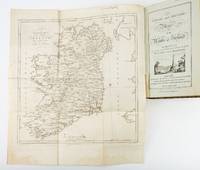
London: Engraved by G. Terry and Sold by T. Longman, London and W. Wilson, Dublin, 1783. Second, Corrected Edition. 260 x 155 mm. (10 1/4 x 6"). XXVII, 289 pp., [4] leaves (index).
Contemporary half calf over marbled boards, flat spine divided into panels by gilt rules, red morocco label (very neat repair to head of front joint and top of spine). Engraved title page (with vignette) and dedication leaf, large folding map of Ireland, and 289 engraved maps. Title page with early ink signature of Jos. Sabine[?]. Moreland & Bannister, p. 190; Tooley, "Maps and Mapmakers," p. 94. ◆Small signs of age and wear to the binding (including slight crackling and nicks to the spine), folding map with faint dampstain to tail margin, two negligible ink spots to blank area on the map of the Irish Sea, but A VERY APPEALING COPY, quite clean and remarkably fresh internally, and in an entirely solid period binding.
This is the second, corrected edition of the first comprehensive road atlas of Ireland, offered here in especially attractive condition. In response to increasing demand for accurate maps of the country's road system, the Irish House of Commons commissioned George Taylor and Andrew Skinner (who together had previously produced the first road atlas of Scotland, among other works), to undertake a survey of the land. Taylor and Skinner completed their work in 1777, and published the first edition of their findings in 1778. This second edition includes updates to the year 1783, as well as an additional map (no. 289). Renowned for their precision and detail, Taylor and Skinner's maps clearly show roads, crossroads, and bridges, as well as topographical features such as hills, lakes, and rivers (including the direction of the water flow); landmarks such as castles, churches, and ruins; and the names of local landlords and their homes. The maps appear either as half-page strips or in full-page, and the distances are given in both Irish and English miles (11 Irish miles being equal to 14 British miles). The robust list of subscribers, which includes a number of earls, viscounts, lords, bishops, and British and Irish army men, demonstrates the great need for, and widespread success of, this important work. While not a rare book, this is the kind of volume that would have normally encountered frequent and inevitably damaging use, so to find a copy as well preserved as this one is a lucky occurrence..
Reviews
(Log in or Create an Account first!)
Details
- Bookseller
- Phillip J. Pirages Fine Books and Medieval Manuscripts
 (US)
(US)
- Bookseller's Inventory #
- ST19355
- Title
- TAYLOR AND SKINNER'S MAPS OF THE ROADS OF IRELAND: SURVEYED IN 1777 AND CORRECTED DOWN TO 1783
- Author
- (IRELAND - MAPS). TAYLOR, GEORGE and ANDREW SKINNER
- Book Condition
- Used
- Quantity Available
- 1
- Edition
- Second, Corrected Edition
- Publisher
- Engraved by G. Terry and Sold by T. Longman, London and W. Wilson, Dublin
- Place of Publication
- London
- Date Published
- 1783
Terms of Sale
Phillip J. Pirages Fine Books and Medieval Manuscripts
30 day return guarantee, with full refund including shipping costs for up to 30 days after delivery if an item arrives misdescribed or damaged.
- Does the default shipping charge seem high? If so, please contact us by email at info@pirages.com for a shipping charge tailored to your order and location. You may also call us at (800) 962-6666 in the US or (503) 472-0476 outside the US, Monday through Friday between the hours of 10 am and 4 pm US Pacific time or leave us a message.
- For all orders outside the US and Canada, please contact us for shipping charges before completing your order.
- If you complete your order before you receive a shipping quote, we will need to contact you to get additional funding to cover the cost of shipping before we can ship your items.
- Except in the cases of items priced at $100 or less (for which we charge a small handling fee), we wish only to pass along actual carrier charges to our customers. The constraints of this website force us to assume that each purchase is both heavier and further away than average, so we would be pleased to adjust the charges to reflect actual weights and locations.
About the Seller
Phillip J. Pirages Fine Books and Medieval Manuscripts
Biblio member since 2006
McMinnville, Oregon
About Phillip J. Pirages Fine Books and Medieval Manuscripts
Phillip J. Pirages Fine Books an Manuscripts was established in 1978 on a ping pong table in a basement in Kalamazoo, Michigan. From the beginning, its founder was willing to sell a range of material, but over the years, the business has gravitated toward historical artifacts that are physically attractive in some way--illuminated material, fine bindings, books printed on vellum, fore-edge paintings, beautiful typography and paper, impressive illustration. Today, the company still sells a wide range of things, from (scruffy) ninth century leaves to biblical material from all periods to Wing and STC imprints to modern private press books to artists' bindings. While we are forgiving about condition when something is of considerable rarity, we always try to obtain the most attractive copies possible of whatever we offer for sale.
Glossary
Some terminology that may be used in this description includes:
- First Edition
- In book collecting, the first edition is the earliest published form of a book. A book may have more than one first edition in...
- Calf
- Calf or calf hide is a common form of leather binding. Calf binding is naturally a light brown but there are ways to treat the...
- Leaves
- Very generally, "leaves" refers to the pages of a book, as in the common phrase, "loose-leaf pages." A leaf is a single sheet...
- Spine
- The outer portion of a book which covers the actual binding. The spine usually faces outward when a book is placed on a shelf....
- Gilt
- The decorative application of gold or gold coloring to a portion of a book on the spine, edges of the text block, or an inlay in...
- Marbled boards
- ...
- Title Page
- A page at the front of a book which may contain the title of the book, any subtitles, the authors, contributors, editors, the...
- G
- Good describes the average used and worn book that has all pages or leaves present. Any defects must be noted. (as defined by AB...
- Tail
- The heel of the spine.
- Morocco
- Morocco is a style of leather book binding that is usually made with goatskin, as it is durable and easy to dye. (see also...
This Book’s Categories

Mary Shelley - Mother of Science Fiction
“I have love in me the likes of which you can scarcely imagine and rage the likes of which you would not believe. If I cannot satisfy the one, I will indulge the other.” - Learn more about Mary Shelley, the author of Frankenstein

Collecting Classic Supernatural Fiction
Classic supernatural fiction is distinct from contemporary horror because it is more literate and often relies upon poetic subtlety rather than unpleasant gratuity to create an atmosphere. Enter if you dare!