Description:
Washington, 1849. Very good. Lithograph map in seven sections, with each sheet measuring approximately 15.5 x 25 inches. Not bound. Second issue of this monumental and important map of the Oregon Trail, described by Wheat as "a road guide for Oregon emigrants such as had never previously existed." The second issue is nearly identical to the first (which appeared in 1846), but the lithographer's name has been omitted and the numbering of sheets III and VI is reversed. An exceptionally clean set, with no splits or repairs, and almost none of the toning often seen along the folds. Charles Preuss was a Prussian-born surveyor and cartographer who accompanied John C. Fremont on three of his five exploratory expeditions in the American West. His first great map, illustrating Fremont's explorations of 1842 to the Rocky Mountains and of 1843-44 to Oregon and California, was published in 1845. Fremont set off on his third expedition later that year, but Preuss remained behind, using information compiled…
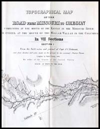
Read More TOPOGRAPHICAL MAP OF THE ROAD FROM MISSOURI TO OREGON COMMENCING AT THE MOUTH OF THE KANSAS IN THE MISSOURI RIVER AND ENDING AT THE MOUTH OF THE WALLAH WALLAH IN THE COLUMBIA. IN SEVEN SECTIONS. FROM THE FIELD NOTES AND JOURNAL OF CAPT. J. C. FREMONT AND FROM SKETCHES AND NOTES MADE BY ON THE GROUND... by Preuss, Charles - 1846
by Preuss, Charles
Similar copies are shown below.
Similar copies are shown to the right.

TOPOGRAPHICAL MAP OF THE ROAD FROM MISSOURI TO OREGON COMMENCING AT THE MOUTH OF THE KANSAS IN THE MISSOURI RIVER AND ENDING AT THE MOUTH OF THE WALLAH WALLAH IN THE COLUMBIA. IN SEVEN SECTIONS. FROM THE FIELD NOTES AND JOURNAL OF CAPT. J. C. FREMONT AND FROM SKETCHES AND NOTES MADE BY ON THE GROUND...
by Preuss, Charles
- Used
- Hardcover
- first
Wash., , 1846. First edition. Sections # 3-7 only, oblong folio, with strip as binding (26 x 166 inches). In cloth slipcase. One of the finest overland maps. Eberstadt Cat 137:518: "This valuable overland guide map must to be confused with those found in Fremont's reports. Preuss was topographer on the... first expedition and herein records the daily stopping places, with notes on the country, water, wood, game, Indians and other subjects of interest or reasons for caution along the way. Each of the seven map extracts from Fremont's report relevant to the portion of the road depicted." Wagner-Camp-Becker 115 (note). Wheat, Transmississippi West Vol. 3 pp.25-29, with all sections included. The map is #523 (lists by title and mileage all 7 parts). Streeter Sale 3100. Graff 3360.
-
Bookseller
Michael Ginsberg Books
 (US)
(US)
- Book Condition Used
- Quantity Available 1
- Edition First edition
- Binding Hardcover
- Place of Publication Wash.,
- Date Published 1846
- Keywords WESTERN AMERICANA; VOYAGE & TRAVEL; MAP; MISSOURI; OREGON
We have 2 copies available starting at $4,500.00.
More Photos
Topographical Map of the Road From Missouri To Oregon Commencing at the Mouth of the Kansas in the Missouri River and Ending at the Mouth of the Wallah Wallah in the Columbia
by Preuss. Charles; Fremont, John Charles
- Used
- very good
- Condition
- Used - Very good
- Quantity Available
- 1
- Seller
-
Chehalis, Washington, United States
- Item Price
-
$4,500.00
Show Details
Item Price
$4,500.00

More Photos
Topographical map of the road from Missouri to Oregon, commencing at the mouth of the Kansas in the Missouri River and ending at the mouth of the Wallah Wallah in the Columbia, in VII sections : from the field notes and journal of Capt. J.C. Fremont, and from sketches and notes made on the ground by his assistant Charles Preuss ; compiled by Charles Preuss, 1846, by order of the Senate of the United States
by Preuss, Charles
- Used
- Condition
- Used
- Quantity Available
- 1
- Seller
-
Garrison, New York, United States
- Item Price
-
$4,500.00
Show Details
Description:
Baltimore: E. Weber & Co. Lithographer, 1846. First issue of the first map "to show the Oregon Trail accurately with great detail" (Rumsey); "An extraordinary map by a master cartographer" (Graff). "Used by many of the overland trail parties, and published only three years before the gold rush, it was based on the 1,670 mile journey of 1842-3 lead by John Charles Fremont, from the Missouri to the Columbia Rivers, by the cartographer Charles Preuss. "This valuable overland guide map must not be confused with those found in Fremont's reports. Preuss was topographer on the "Pathfinder's" first Fremont expedition and herein records the daily stopping places with notes on the country, water, wood, game, Indians, and other subjects of interest or reasons for caution along the way. Each of the seven map-sections has its own separate title together with observations and extracts from Fremont's Report relevant to the portion of the route depicted." One of the observations pertains to the Great Salt Lake: "one…
Read More Item Price
$4,500.00