
Click for full-size.
The Travellers Guide or Map of the Roads, Canals & Rail Roads of the United States, with the distances from place to place
by Tanner, H. S
- Used
- Condition
- Very good condition
- Seller
-
Garrison, New York, United States
Payment Methods Accepted
About This Item
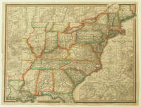
Philadelphia: H. S. Tanner, 144 Chestnut St, 1834. Very good condition. Original outline color map from Tanner's American Traveller guide book extending from the east coast of the United States to Missouri, Arkansas and Louisiana. Major towns, rivers, turnpike and common roads, rail routes, canals and steamboat routes are shown.
With eighteen inset maps of major cities and their environs including: Albany, Saratoga &c.; Baltimore & Washington; Cincinnati; Environs of Boston; Environs of Charleston; Environs of Montreal; Environs of New York; Environs of Philadelphia; Environs of Pittsburg; Environs of Providence; Environs of Quebec; Environs of Richmond; Falls of Niagara &c.; Hudson River; Louisville &c.; New Orleans; Pottsville &c.; and Washington D.C.
The inset of the Hudson River extends from Staten Island up to Kingston, New York.
Image size: 22 1/2 x 18 1/4". Paper size: 23 1/4 x 19 1/4". OCLC: 1084637886 locates one copy at the Library of Congress. Beautiful period hand color, very good condition, no cracking.
Reviews
(Log in or Create an Account first!)
Details
- Bookseller
- Antipodean Books, Maps & Prints
 (US)
(US)
- Bookseller's Inventory #
- 15891
- Title
- The Travellers Guide or Map of the Roads, Canals & Rail Roads of the United States, with the distances from place to place
- Author
- Tanner, H. S
- Book Condition
- Used - Very good condition
- Quantity Available
- 1
- Publisher
- H. S. Tanner, 144 Chestnut St
- Place of Publication
- Philadelphia
- Date Published
- 1834
- Bookseller catalogs
- MAPS; HUDSON RIVER;
Terms of Sale
Antipodean Books, Maps & Prints
30 day return guarantee, with full refund including shipping costs for up to 10 days after delivery if an item arrives mis-described or damaged.
About the Seller
Antipodean Books, Maps & Prints
Biblio member since 2009
Garrison, New York
About Antipodean Books, Maps & Prints
Booksellers for over 40 years, members of prominent trade associations (ABAA, ILAB, ANZAAB, IMCOS, ANZMS, PBFA). We are located at Garrison NY, a stone's throw from the Metro North Hudson line train, just over 1 hr. from NYC on the banks of the Hudson River. Books, maps, prints & ephemera bought & sold.
Glossary
Some terminology that may be used in this description includes:
- New
- A new book is a book previously not circulated to a buyer. Although a new book is typically free of any faults or defects, "new"...
This Book’s Categories

Collecting the 1939 New York World’s Fair
Born in the midst of the Great Depression, the theme of the 1939 World’s Fair was “The World of Tomorrow” - a theme that captured the hearts of a generation. Check out the maps, souvenirs, and other ephemera on Biblio!

What did people buy in 2020?
Plague journals, escapist literature, political history: explore our year in review, where we share rare book trends and a gallery of some of the most beautiful and interesting books sold in 2020.