(World Map from Keur bible): Wereldkaart
by Jagen, Jan Van
- Used
- very good
- Condition
- Very Good
- Seller
-
Crozet, Virginia, United States
Payment Methods Accepted
About This Item
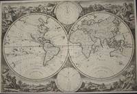
Dordrecht: Keur, 1748. Very good double hemisphere world map from a Keur bible, b&w as issued. The engraver/designer for this map was J. v. Jagen (sculps. et dir.; engraved on lower central edge of plate just inside neatline). Folds as issued. Two smaller spheres upper (Polus Arcticus) and lower (Polus Antarcticus) center. The majority of place names and verso text are in Dtuch. The decorative allegorical surrounds are quite nice. The map image measures 30 x 45 cm, with the diameter of each hemisphere measuring 22 cm. The Keur family were active bible publishers from the mid 17th to mid 18th centuries. This particular map corresponds to variant K III, entry 137, p. 205 in Poortman and Augusteijn's "Kaarten in Bijbels..." The map date is approximate. There is no recto title banner for this issue.. Very Good. Map.
Reviews
(Log in or Create an Account first!)
Details
- Bookseller
- The Prime Meridian: Antique Maps & Books
 (US)
(US)
- Bookseller's Inventory #
- 3538
- Title
- (World Map from Keur bible): Wereldkaart
- Author
- Jagen, Jan Van
- Book Condition
- Used - Very Good
- Publisher
- Keur
- Place of Publication
- Dordrecht
- Date Published
- 1748
- Keywords
- World Map, Maps, History, Cartography, Bible, Geography,
- Bookseller catalogs
- D. Maps--General;
Terms of Sale
The Prime Meridian: Antique Maps & Books
We accept cash, check, money order, American Express, Visa, Discover and Mastercard. Virginia sales tax will be added to instate purchases. Shipping charges are billed at cost, and will be added to the invoice. We usually include insurance with the postage, and as a result we do not routinely use media mail. If you wish the book sent via the latter route, it would be at your risk. For heavy items, there may be extra shipping charges. Any item maybe returned (postpaid and carefully packed by purchaser) within 7 days of receipt. We do not generally refund postal charges. Please notify us before sending a return. We do not share customer information with any outside sources; all details and addresses are confidential.
About the Seller
The Prime Meridian: Antique Maps & Books
Biblio member since 2005
Crozet, Virginia
About The Prime Meridian: Antique Maps & Books
The Prime Meridian: Antique Maps & Books is owned and operated by Joel & Deborah Kovarsky. We first opened in 1998, but have had a decades-old interest in old maps, books, and paper, stemming from a comparable long-standing interest in how knowledge is used. Our business is run via the internet. We do not run an open shop, however we do welcome visitors by appointment only. Before attempting a visit, please contact us. We are a specialty business, dealing in antiquarian maps and related books (atlases, history of cartography, selected reference books, etc.). Please feel free to contact us for specific inquiries.
Glossary
Some terminology that may be used in this description includes:
- Plate
- Full page illustration or photograph. Plates are printed separately from the text of the book, and bound in at production. I.e.,...
- Recto
- The page on the right side of a book, with the term Verso used to describe the page on the left side.
- Verso
- The page bound on the left side of a book, opposite to the recto page.

Collecting Aleister Crowley
Aleister Crowley was a well-known and highly controversial figure in the first half of the 20th Century. A writer, occultist, magician, and mountaineer, Crowley impacted a diverse collection of sub-cultures and interests. See collectible Crowley from Biblio booksellers.

Using and Collecting Bookmarks
Bern Marcowitz warns against paperclips and other inappropriate page-savers, and offers a bit of advice on using and collecting bookmarks.