Description:
Paris: Librairie Furne, c. 1874. Hardcover. Very Good. 66 maps folded in half attached to binding with paper strips. 9 1/2 x 11 1/4 in. . Black cloth spine binding with mottled green and black boards, gold lettering on cover. Condition of the book is VERY GOOD: light wear to covers and spines, corners a bit more worn, heavier wear to rear spine edge- rear cover a bit loose, green on covers faded on all edges, edges of text block lightly darkened, end papers tanned, hinges starting to crack, small book plate of David. B. Ogden on inside of front cover. Maps very white and overall clean- occasional light spotty foxing near top edge of fold and side edges, all maps attached.
Search Results: Geography from Andre Strong Bookseller
You searched for:
- Subject: Geography from Andre Strong Bookseller
Results 1 - 20 of 26

ATLAS DE L'HISTOIRE DU CONSULAT ET DE L'EMPIRE: Dresse et Dessine sous la Direction de M. Thiers par MM. A. Dufour et Duvotenay - Grave en Relief par M. Gillot
by M. A. Thiers
- Used
- very good
- Hardcover
- Condition
- Used - Very Good
- Binding
- Hardcover
- Quantity Available
- 1
- Seller
-
Blue Hill, Maine, United States
- Item Price
-
$450.00$6.00 shipping to USA
Show Details
Item Price
$450.00
$6.00
shipping to USA

ATLAS DES CAMPAGNES DEL LA REVOLUTION FRANCAISE: Dresse par Th. Duvotenay - Grave par Ch. Doynnet
by M. A. Thiers
- Used
- very good
- Hardcover
- Condition
- Used - Very Good
- Binding
- Hardcover
- Quantity Available
- 1
- Seller
-
Blue Hill, Maine, United States
- Item Price
-
$375.00$6.00 shipping to USA
Show Details
Description:
Paris: Librairie Furne, c. 1870. Hardcover. Very Good. 32 maps folded in half attached to binding with paper strips. 9 1/2 x 11 1/4 in. . Black cloth spine binding with mottled green and black boards, gold lettering on cover. Condition of the book is VERY GOOD: light wear to covers and spines, corners a bit more worn, heavier wear to front cover- top edge near spine signifigantly chewed by mice, green on front cover faded on all edges, edges of text block lightly darkened, end papers tanned, hinges starting to crack. Maps very white and overall clean- occasional light spotty foxing near top edge of fold and side edges, all maps attached. NOTE- front cover mouse damage does not affect the maps.
Item Price
$375.00
$6.00
shipping to USA
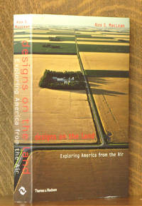
DESIGNS ON THE LAND EXPLORING AMERICA FROM THE AIR
by Ales MacLean
- Used
- Paperback
- first
- Condition
- Used - Very Good +
- Edition
- First American edition
- Binding
- Paperback
- ISBN 10 / ISBN 13
- 9780500284148 / 0500284148
- Quantity Available
- 1
- Seller
-
Blue Hill, Maine, United States
- Item Price
-
$15.00$6.00 shipping to USA
Show Details
Description:
New York: Thames and Hudson, 2003. First American edition. Paperback. Very Good +. 7 x 10 in. Paper wraps. Condition is VERY GOOD+ ; mild edge wear, covers clean. Binding tight and text unmarked. Geog. Stax.
Item Price
$15.00
$6.00
shipping to USA

FRANCE PITTORESQUE: ou Description Pittoresque, Topographique, et Statistique des Departments et Colonies de la France. (Volume I only)
by A. Hugo
- Used
- good
- Hardcover
- Condition
- Used - Good
- Binding
- Hardcover
- Quantity Available
- 1
- Seller
-
Blue Hill, Maine, United States
- Item Price
-
$65.00$6.00 shipping to USA
Show Details
Description:
Paris: Chez Delloye, Editeur de la France Militaire, 1835. Hardcover. Good. viii + 320 pages. 7 x 11 in. high. Quarter calf over mottled boards with gilt titles on spine. Condition of book is GOOD; Leather ripped at edges at top & bottom of spine, heavy wear to edges of covers, one corner missing, all maps & illustrations are present, some with light foxing, but most are very clean & bright.
Item Price
$65.00
$6.00
shipping to USA
GEOGRAPHY OF NEWFOUNDLAND FOR THE USE OF SCHOOLS
by William Pilot
- Used
- Hardcover
- first
- Condition
- Used - Good +
- Edition
- First edition
- Binding
- Hardcover
- Quantity Available
- 1
- Seller
-
Blue Hill, Maine, United States
- Item Price
-
$50.00$6.00 shipping to USA
Show Details
Description:
London: William Collins Sons and Co., c. 1908. First edition. Hardcover. Good +. 5 x 7 in. 64 pp. Green cloth boards. Condition is GOOD ; covers quite worn with creasing to rear board cloth. Front hinge is started with muslin visible but not broken. Color frontis map has lost it's lower half, Text has a few slight marks to paper, no written markings. Scarce. Geog. Stax.
Item Price
$50.00
$6.00
shipping to USA
More Photos
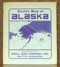
KROLL'S MAP OF ALASKA
by Kroll
- Used
- Paperback
- Condition
- Used - Very Good +
- Binding
- Paperback
- Quantity Available
- 1
- Seller
-
Blue Hill, Maine, United States
- Item Price
-
$15.00$6.00 shipping to USA
Show Details
Description:
Seattle WA: Kroll Map Company, c 1960. Paperback. Very Good +. 38 x 43 inches, folds to 9 1/2 x 11 inches. No date but text on back of envelope mentions 1959 statehood. Price is $2.95. In original envelope. Condition of the map is Very Good+, looks new, colors vibrant, very clean and unmarked, no tears. Envelope is Very Good, light toning and wear at edges. STK
Item Price
$15.00
$6.00
shipping to USA
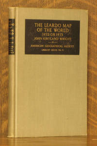
THE LEARDO MAP OF THE WORLD - 1452 OR 1453
by John Kirtland Wright, A.B. Hoen
- Used
- very good
- Hardcover
- first
- Condition
- Used - Very Good
- Edition
- First edition
- Binding
- Hardcover
- Quantity Available
- 1
- Seller
-
Blue Hill, Maine, United States
- Item Price
-
$15.00$6.00 shipping to USA
Show Details
Description:
New York: American Geographical Society, 1928. First edition. Hardcover. Very Good. 5 x 7 1/2 inches. 74 pages + 10 maps. Condition is Very Good, corners lightly bumped, text and illustrations are very clean, binding is tight. STK
Item Price
$15.00
$6.00
shipping to USA
A LITERARY & HISTORICAL ATLAS OF ASIA
by J. G. Bartholomew
- Used
- very good
- Hardcover
- Condition
- Used - Very Good
- Binding
- Hardcover
- Quantity Available
- 1
- Seller
-
Blue Hill, Maine, United States
- Item Price
-
$45.00$6.00 shipping to USA
Show Details
Description:
London & New York: J.M. Dent & Sons/ E.p. Dutton & Co., c 1920. Hardcover. Very Good. 4 1/2 x 7 inches. xi, 226 pages. No date c. 1920. Condition is Very Good; Spine slightly faded, pevios owner's name, dated 1923, on half title page, text and illustrations are very clean, binding is tight. STK
Item Price
$45.00
$6.00
shipping to USA
More Photos
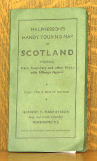
MACPHERSON'S NEW HANDY MAP OF SCOTLAND - FOR MOTORISTS, CYCLISTS AND TOURISTS. SCALE, 12 MILES TO ONE INCH. SHOWING MAIN, SECONDARY OND OTHER ROADS WITH MILEAGE FIGURES
by Herbert T. Macpherson
- Used
- very good
- Paperback
- Condition
- Used - Very Good
- Binding
- Paperback
- Quantity Available
- 1
- Seller
-
Blue Hill, Maine, United States
- Item Price
-
$15.00$6.00 shipping to USA
Show Details
Description:
Dunfermline UK: Herbert T. Macpherson. Paperback. Very Good. 4 x 7 inches, 20 x 25 inches unfolded. No date, 1950s? Condition is Very Good, one small tear at a fold otherwise excellent. STK
Item Price
$15.00
$6.00
shipping to USA
NATURAL ADVANCED GEOGRAPHY
by Jacques Redway
- Used
- Hardcover
- Condition
- Used - Good +
- Binding
- Hardcover
- Quantity Available
- 1
- Seller
-
Blue Hill, Maine, United States
- Item Price
-
$20.00$6.00 shipping to USA
Show Details
Description:
New York: American Book Co., 1901. Hardcover. Good +. 10 x 13 in. Cloth boards have been covered with old wallpaper. Condition is GOOD+ ; edges worn, covers have some water stains. Binding strong and text unmarked. Color maps.
Item Price
$20.00
$6.00
shipping to USA

NEUER VOLKS UND FAMILIEN ATLAS IN EINHUNDERT KARTENSEITEN
by Velhagen and Klasings
- Used
- good
- Hardcover
- Condition
- Used - Good
- Binding
- Hardcover
- Quantity Available
- 1
- Seller
-
Blue Hill, Maine, United States
- Item Price
-
$50.00$6.00 shipping to USA
Show Details
Description:
Bielefeld: Velhagen & Klasings. Hardcover. Good. 100 p. of maps in color. 12 x 18 in. Tan cloth binding, front cover embossed with red lettering. Condition of the book is GOOD: wear and soiling to covers and spine- heavier at corners, spine worn and detached at front, edges of text block lightly darkened, maps clean, binding split.
Item Price
$50.00
$6.00
shipping to USA
More Photos
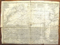
A NEW CHART OF THE VAST ATLANTIC OCEAN EXHIBITING THE SEAT OF WAR, BOTH IN EUROPE AND AMERICA...
by Emanuel Bowen
- Used
- very good
- first
- Condition
- Used - Very Good
- Edition
- First edition
- Quantity Available
- 1
- Seller
-
Blue Hill, Maine, United States
- Item Price
-
$175.00$6.00 shipping to USA
Show Details
Description:
London: London Magazine, 1740. First edition. Map. Very Good. 12 1/2 x 17 1/2 inches. This map was originally published in London Magazine in 1740. Printed at top center 'A Table Comparing this Chart with Mr. Popples Great Map of the British Empire in America'. Condition is Very Good; light vertical crease at center fold, a few small tears at edges, one inch vertical tear at center fold at compass rose at center. RGGR
Item Price
$175.00
$6.00
shipping to USA
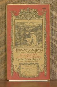
ORDNANCE SURVEY CONTOURED ROAD MAP OF ST. DAVID'S AND CARDIGAN Popular edition Scale 1 inch to 1 mile- Sheet # 88
by Ordnance Survey
- Used
- very good
- Condition
- Used - Very Good
- Quantity Available
- 1
- Seller
-
Blue Hill, Maine, United States
- Item Price
-
$20.00$6.00 shipping to USA
Show Details
Description:
Southampton: Ordnance Survey Office/ E.M. Jack Dir., 1923. Map. Very Good. 4 X 7 in. high. unfolds to 36 X 23 1/2 inches. Condition of the book is VERY GOOD; Map is very clean, lightly rubbed at folds, but no splits or tears. Geography Ephemera
Item Price
$20.00
$6.00
shipping to USA
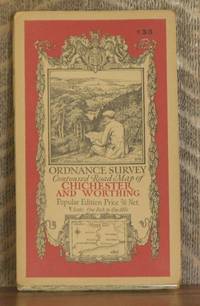
ORDNANCE SURVEY CONTOURED ROAD MAP OF CHICHESTER AND WORTHING Popular edition Scale 1 inch to 1 mile- Sheet # 133
by Ordnance Survey
- Used
- very good
- Condition
- Used - Very Good
- Edition
- Third revised edition
- Quantity Available
- 1
- Seller
-
Blue Hill, Maine, United States
- Item Price
-
$20.00$6.00 shipping to USA
Show Details
Description:
Southampton: Ordnance Survey Office/ Charles Close Dir., 1929. Third revised edition. Map. Very Good. 4 X 7 in. high. unfolds to 29 1/2 X 22 inches. Condition of the book is VERY GOOD; Map is very clean, lightly rubbed at folds, but no splits or tears. Geography Ephemera
Item Price
$20.00
$6.00
shipping to USA

ORDNANCE SURVEY CONTOURED ROAD MAP OF PEMBROKE AND TENBY Popular edition Scale 1 inch to 1 mile- Sheet # 99
by Ordnance Survey
- Used
- very good
- Condition
- Used - Very Good
- Edition
- Third revised edition
- Quantity Available
- 1
- Seller
-
Blue Hill, Maine, United States
- Item Price
-
$20.00$6.00 shipping to USA
Show Details
Description:
Southampton: Ordnance Survey Office/ Charles Close Dir., 1930. Third revised edition. Map. Very Good. 4 X 7 in. high. unfolds to 38 X 24 1/2 inches. Condition of the book is VERY GOOD; Map is very clean, lightly rubbed at folds, but no splits or tears. Geography Ephemera
Item Price
$20.00
$6.00
shipping to USA
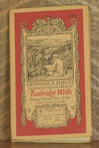
ORDNANCE SURVEY CONTOURED ROAD MAP OF TUNBRIDGE WELLS Popular edition Scale 1 inch to 1 mile- Sheet # 125
by Ordnance Survey
- Used
- very good
- Condition
- Used - Very Good
- Edition
- Third revised edition
- Quantity Available
- 1
- Seller
-
Blue Hill, Maine, United States
- Item Price
-
$20.00$6.00 shipping to USA
Show Details
Description:
Southampton: Ordnance Survey Office/ Charles Close Dir., 1930. Third revised edition. Map. Very Good. 4 X 7 in. high. unfolds to 29 1/2 X 22 inches. Condition of the book is VERY GOOD; Map is very clean, lightly rubbed at folds, but no splits or tears. Geography Ephemera
Item Price
$20.00
$6.00
shipping to USA
![ORDNANCE SURVEY ONE-INCH MAP OF GREAT BRITAIN - IPSWICH [NATIONAL GRID SEVENTH SERIES] SHEET 150](https://d3525k1ryd2155.cloudfront.net/h/266/597/851597266.0.m.jpg)
ORDNANCE SURVEY ONE-INCH MAP OF GREAT BRITAIN - IPSWICH [NATIONAL GRID SEVENTH SERIES] SHEET 150
by Ordnance Survey
- Used
- very good
- Paperback
- Condition
- Used - Very Good
- Binding
- Paperback
- Quantity Available
- 1
- Seller
-
Blue Hill, Maine, United States
- Item Price
-
$15.00$6.00 shipping to USA
Show Details
Description:
Chessington: Ordnance Survey, 1956. Paperback. Very Good. 5 x 8 1/2 inches. Condition is Very Good; Very clean with no markings. STK
Item Price
$15.00
$6.00
shipping to USA
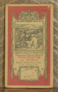
ORDNANCE SURVEY CONTOURED ROAD MAP OF WINCHESTER AND DISTRICT Popular edition Scale 1 inch to 1 mile- Sheet # 123
by Ordnance Survey
- Used
- very good
- Condition
- Used - Very Good
- Edition
- Third revised edition
- Quantity Available
- 1
- Seller
-
Blue Hill, Maine, United States
- Item Price
-
$20.00$6.00 shipping to USA
Show Details
Description:
Southampton: Ordnance Survey Office/ Charles Close Dir., 1931. Third revised edition. Map. Very Good. 4 X 7 in. high. unfolds to 29 1/2 X 22 inches. Condition of the book is VERY GOOD; Map is very clean, lightly rubbed at folds, but no splits or tears. Geography Ephemera
Item Price
$20.00
$6.00
shipping to USA
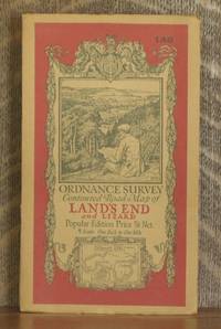
ORDNANCE SURVEY CONTOURED ROAD MAP OF LAND'S END AND LIZARD Popular edition Scale 1 inch to 1 mile- Sheet # 146
by Ordnance Survey
- Used
- very good
- Condition
- Used - Very Good
- Edition
- Third revised edition
- Quantity Available
- 1
- Seller
-
Blue Hill, Maine, United States
- Item Price
-
$20.00$6.00 shipping to USA
Show Details
Description:
Southampton: Ordnance Survey Office/ Charles Close Dir., 1931. Third revised edition. Map. Very Good. 4 X 7 in. high. unfolds to 34 1/2 X 28 inches. Condition of the book is VERY GOOD; Map is very clean, lightly rubbed at folds, but no splits or tears. Geography Ephemera
Item Price
$20.00
$6.00
shipping to USA

ORDNANCE SURVEY CONTOURED ROAD MAP OF SIDMOUTH AND BRIDPORT Popular edition Scale 1 inch to 1 mile- Sheet # 139
by Ordnance Survey
- Used
- very good
- Condition
- Used - Very Good
- Quantity Available
- 1
- Seller
-
Blue Hill, Maine, United States
- Item Price
-
$20.00$6.00 shipping to USA
Show Details
Description:
Southampton: Ordnance Survey Office/ Charles Close Dir., 1924. Map. Very Good. 4 X 7 in. high. unfolds to 30 X 21 inches. Condition of the book is VERY GOOD; Map is very clean, lightly rubbed at folds, but no splits or tears. Geography Ephemera
Item Price
$20.00
$6.00
shipping to USA

Didn’t find what you’re looking for?
Try adding this search to your want list. Millions of books are added to our site everyday and when we find one that matches your search, we’ll send you an email. Best of all, it’s free.
Add to Want List

Are you a frequent reader or book collector?
Join the Bibliophile's Club and save 10% on every purchase, every day — up to $20 savings per order!

Social Responsibility
Did you know that since 2004, Biblio has used its profits to build 16 public libraries in rural villages of South America?