Travel from George Jeffery Books
New Arrivals
More Photos
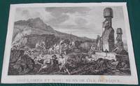
Insulaires et monumens de l'Ile de Paque
by Duche de Vancy, Gaspard ; La Perouse, Jean-Francois de Galaup, comte De
- Condition
- Used - Near Very Good
- Published
- 1797
- Quantity Available
- 1
- Seller
-
CHESHUNT, Hertfordshire, GBR
- Item Price
-
$109.56
Show Details
Description:
Paris: L'Imprimerie de la Republique, 1797. Print measures 40x25.cm. Some light surface wear, stain mark on margin. Print in good clean condition. . Near Very Good. Illus. by Godefroy. Item Price
$109.56

More Photos
Alten Stettin. Szczecin in Poland (called Stettin for much of its history).
by Braun & Hogenberg'
- Condition
- Used - Very Good
- Published
- 1580
- Quantity Available
- 1
- Seller
-
CHESHUNT, Hertfordshire, GBR
- Item Price
-
$837.85
Show Details
Description:
Braun & Hogenberg', 1580. Large folding plan. Plan, engraved area measures 48x33.5.cm, plus margin. Some light creasing, surface wear, 2 small single pin/worm holes. Print in good clean condition. . Very Good. Item Price
$837.85

More Photos
"Recens Elaborata Mappa Geographica Regni Brasiliae in America Meridionali Maxime Celebris Accuaratae Delineata".
by Seutter, Matthias
- Condition
- Used - Very Good
- Published
- 1730
- Quantity Available
- 1
- Seller
-
CHESHUNT, Hertfordshire, GBR
- Item Price
-
$418.92
Show Details
Description:
Matthaeus Seutter in Augsburg, 1730. Large hand coloured map. Map measure 56x50 cm. [ 22x19.5 iches ]. Some light wear on fold, some light browning. A very nice clean map. . Very Good. Item Price
$418.92

More Photos
Episcopatus Paderbornensis descriptio Nova
by Jodocus Hondius
- Condition
- Used - Very Good
- Published
- 1633
- Quantity Available
- 1
- Seller
-
CHESHUNT, Hertfordshire, GBR
- Item Price
-
$418.92
Show Details
Description:
Amsterdam: Henricus Hondius, 1633. No printed date, circa 1633.Large folding hand coloured map. Not printed on verso. Map, engraved area measures 49.5x37.cm, plus margin. Some light spotting, mainly to margin. Map in good clean condition. . Very Good. Item Price
$418.92

More Photos
Carte de la Province de Quito au Perou Dressee sur les Observations Astronomiques, Mesures Geographiques, Journaux de Route et Memoires de Mr. de la Condamine.
by Condamine, Charles Marie de La
- Condition
- Used - Very Good
- Published
- 1751
- Quantity Available
- 1
- Seller
-
CHESHUNT, Hertfordshire, GBR
- Item Price
-
$418.92
Show Details
Description:
Jean-Baptiste Bourguignon d'Anville, 1751. Large hand coloured map. Map, engraved area measures 35x59.cm, plus margin. Some light surface wear, mainly on folds. Map in very good clean condition. A detailed map from Condamine's survey of 1735-49 to determine the curvature of the earth at the equator, published by d'Anville. The map shows the triangulation points used in the valley between… Read more about this item Item Price
$418.92

More Photos
The Galapagos Islands Discovered and Described by Capt. Cowley in 1684
by Bowen Emanuel
- Condition
- Used - Very Good
- Published
- 1744
- Quantity Available
- 1
- Seller
-
CHESHUNT, Hertfordshire, GBR
- Item Price
-
$418.92
Show Details
Description:
London: Emanuel Bowen, 1744. Hand coloured map, engraved area measures 19.5x31.5.cm, plus margin. Some light dust/dirt making, some light stain marking. Map in good clean condition. One of the few early maps to focus solely on the Galapagos Islands. From Harris's 'Navigantium atque itinerantium bibliotheca or, a complete collection of voyages and travel'.. Very Good. Item Price
$418.92

More Photos
Le Perou et le cours de la rivie`re Amazone, depuis ses sources jusques a` la Mer
by Iohannes Somer Pruthenus
- Condition
- Used - Very Good
- Published
- 1679
- Quantity Available
- 1
- Seller
-
CHESHUNT, Hertfordshire, GBR
- Item Price
-
$290.02
Show Details
Description:
Paris, 1679. Hand coloured map. Map measures 56x41.cm. Some light wear or dirt marking. Map in good clean condition. . Very Good. Item Price
$290.02

More Photos
Costumes des Habitants de la Conception.
by Jean Francois Galoup, Comte La Perouse
- Condition
- Used - Near Very Good
- Published
- 1798
- Quantity Available
- 1
- Seller
-
CHESHUNT, Hertfordshire, GBR
- Item Price
-
$109.56
Show Details
Description:
London: G. G. And J. Robinson, 1798. Engraved surface measures 30x20.cm. Some surface wear, mainly on margin, short closed tear. Generally print in good clean condition. This fascinating engraving depicts the costumes of the local inhabitants in Chile, as seen during La Perouse's voyage. Drawn by Suche-de-Vancy and Jean-Michel Moreau.. Near Very Good. Item Price
$109.56

More Photos
MER DES ANTILLES. Carte de la côte de Terre Ferme de Cumana a Santa Marta
by Boutroux Mr
- Condition
- Used - Very Good
- Published
- 1865
- Quantity Available
- 1
- Seller
-
CHESHUNT, Hertfordshire, GBR
- Item Price
-
$290.02
Show Details
Description:
Paris, 1865. Plain engraved chart of (a part of) the coast of Venezuela. Large folding plan measuring 96x64 [ 38x25 inches ]. Some light foxing. Plan in very good clean condition. . Very Good. Item Price
$290.02

More Photos
Mappa Geographica Regni Poloniae ex novissimis quotquot sunt mappis Specialibus
by Homann (Johann Baptist)
- Condition
- Used - Very Good
- Published
- 1757
- Quantity Available
- 1
- Seller
-
CHESHUNT, Hertfordshire, GBR
- Item Price
-
$418.92
Show Details
Description:
Homann (Johann Baptist), 1757. Large folding hand coloured map. Map, engraved area measures 51.5x44.cm, plus margin. Some light surface wear, light staining, mainly to margin. Map in good clean condition. . Very Good. Item Price
$418.92

More Photos
Panorama de la baie de la Poste (Ile de la Floriana, Galapagos).
by Mesnard
- Condition
- Used - Very Good
- Published
- 1841
- Quantity Available
- 1
- Seller
-
CHESHUNT, Hertfordshire, GBR
- Item Price
-
$483.37
Show Details
Description:
Paris, 1841. View of Post Office Bay on Santa Maria Island or Floreana in the Galapagos archipelago. Panorama on two separate sheets of Paita, Galapolas Islands. Each engraving measures 51x19.cm. Plus boarder. Some light dust marking of staining, short closed tear on margins. Generally both printed in very good clean condition. . Very Good. Illus. by Thierry and Sabatier.. Item Price
$483.37

More Photos
Nova et Accurata Brasiliae totius tabula.
by Schenk Pieter [ Blaeu Joannes ]
- Condition
- Used - Very Good
- Published
- 1720
- Quantity Available
- 1
- Seller
-
CHESHUNT, Hertfordshire, GBR
- Item Price
-
$741.18
Show Details
Description:
Amstelædami: Schenk Amsterdam, 1720. Large hand coloured map. Map, engraved area measures 58.5x50.cm, plus margin. Some light wear, short closed tear to margins. Map in good clean condition. . Very Good. Item Price
$741.18

More Photos
Carte du Mexique ou de la Nlle. Espagne Contenant Aussi le Nouveau Mexique, la Californie, avec une Partie des Pays Adjacents
by Rigobert Bonne
- Condition
- Used - Very Good
- Published
- 1771
- Quantity Available
- 1
- Seller
-
CHESHUNT, Hertfordshire, GBR
- Item Price
-
$418.92
Show Details
Description:
Paris: Jean Lattré, 1771. Large hand coloured map. Map, engraved area measures 42x29.cm, plus margin. Map showing some minor surface wear, mainly along fold, dust marked. Map in good clean condition. . Very Good. Item Price
$418.92

More Photos
The Galapagos Islands Discovered and Described by Capt. Cowley in 1684
by Bowen Emanuel
- Condition
- Used - Very Good
- Published
- 1744
- Quantity Available
- 1
- Seller
-
CHESHUNT, Hertfordshire, GBR
- Item Price
-
$322.25
Show Details
Description:
London: Emanuel Bowen, 1744. Map, engraved area measures 19.5x31.5.cm, plus margin. Some light dust/dirt making. Map in good clean condition. One of the few early maps to focus solely on the Galapagos Islands. From Harris's 'Navigantium atque itinerantium bibliotheca or, a complete collection of voyages and travel'.. Very Good. Item Price
$322.25

More Photos
Carte de la Louisiane, et de la Floride
by Bonne, Rigobert, 1727-1794.
- Condition
- Used - Very Good
- Published
- 1780
- Quantity Available
- 1
- Seller
-
CHESHUNT, Hertfordshire, GBR
- Item Price
-
$322.25
Show Details
Description:
Paris, 1780. Hand coloured map. Map engraved area measures 21x32.cm, plus margin. Light surface wear, 2 small reiars. Map in good clean condition. This handsome map of the Southeast and the Mississippi River Valley extends from Charleston, South Carolina west to include New Orleans and north into southern Illinois. In this French-produced map, Louisiana extends to the Appalachian Mountains bordering… Read more about this item Item Price
$322.25

More Photos
South America with its several divisions, according to the possessions of the european Powers
by Thomas Kitchin
- Condition
- Used - Near Very Good
- Published
- 1794
- Quantity Available
- 1
- Seller
-
CHESHUNT, Hertfordshire, GBR
- Item Price
-
$290.02
Show Details
Description:
London: Laurie and Whittle, 1794. Map engraved area measures 53x44.cm, plus margin. Map has some light wear, starting to split along fold, light browning. Generally map in good clean condition. . Near Very Good. Item Price
$290.02

More Photos
Costumes des Habitants de la Conception.
by Jean Francois Galoup, Comte La Perouse
- Condition
- Used - Near Very Good
- Published
- 1740
- Quantity Available
- 1
- Seller
-
CHESHUNT, Hertfordshire, GBR
- Item Price
-
$186.90
Show Details
Description:
Thomas. Atlas du Voyage de la Pérouse., 1740. Engraved surface measures 40x25.cm. With a good wide magin. Margin has some dust marking, short tears on edges. Engraving in good clean condition. This fascinating engraving depicts the costumes of the local inhabitants in Chile, as seen during La Perouse's voyage. Drawn by Suche-de-Vancy and Jean-Michel Moreau.. Near Very Good. Item Price
$186.90
![Paraquariae Provinciae Soc. Iesu cum Adjacentibus Novissima Descriptio [ Paraguay. South America ]](https://d3525k1ryd2155.cloudfront.net/h/017/227/1606227017.0.m.jpg)
More Photos
Paraquariae Provinciae Soc. Iesu cum Adjacentibus Novissima Descriptio [ Paraguay. South America ]
by Antonio Marchoni
- Condition
- Used - Very Good Plus
- Published
- 1732
- Quantity Available
- 1
- Seller
-
CHESHUNT, Hertfordshire, GBR
- Item Price
-
$612.28
Show Details
Description:
Bern , 1732. Large coloured map. Map measures 50x58.cm. [ 20x23 inches] A sharp impression A very good clean map. Very Good Plus. Item Price
$612.28

More Photos
Naples
by Fitzgerald Sybil
- Condition
- Used - Near Very Good
- Edition
- Limited Edition
- Published
- 1904
- Binding
- Hardcover
- Quantity Available
- 1
- Seller
-
CHESHUNT, Hertfordshire, GBR
- Item Price
-
$212.68
Show Details
Description:
London: Adam & Charles Black , 1904. Limited to 250 copies, signed by Augustine Fitzgerald. Book measures 28x22.cm. xii,234,[1]pp, 80 coloured plates. Bound in original publishers ornate cream cloth. Cloth lightly rubbed, lightly bumped, dust, dirt maked. Generally binding in good condition. Internally, previous owners bookplate. Pages and plates in good clean condition. A good copy. F. Limited Edition. Cloth.… Read more about this item Item Price
$212.68

More Photos
Dottings on the Roadside, in Panama, Nicaragua, and Mosquito
by Pim Bedford Captain R.N.
- Condition
- Used - Very Good
- Published
- 1869
- Binding
- Hardcover
- Quantity Available
- 1
- Seller
-
CHESHUNT, Hertfordshire, GBR
- Item Price
-
$612.28
Show Details
Description:
London: Chapman & Hall, 1869. Book measures 22x15.cm. xvi, 468pp, 2 maps, one coloured folding, 6 coloured tinted plates including frontis. Bound in original publshers embossed and gilt cloth, full gilt edges. At some time the binding has been recased. Binding in very good clean firm condition. Internally, a couple of gatherings slightly protruding, front fixed endpaper has abrasion wear,… Read more about this item Item Price
$612.28