Rare and Antiquarian Books
Rare books from BICKERSTAFF'S BOOKS, MAPS &C.
Results 1 - 15 of 23
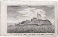
A North View of Castle William in the Harbour of Boston.
by [Boston: Castle William.] Massachusetts Magazine.
- Used
- very good
- Condition
- Used - Very Good
- Seller
-
Scarborough, Maine
- Item Price
-
$1,500.00$10.00 shipping to USA
Show Details
Item Price
$1,500.00
$10.00
shipping to USA

More Photos
Trial of David Lynn, Jabez Meigs, Elijah Barton, Prince Cain, Nathaniel Lynn, Ansel Meigs, and Adam Pitts, for the murder of Paul Chadwick, at Malta, in Maine, on September 8th, 1809...taken in short hand by John Merrick, Esq.
by [Law.] [Early Maine Trial.]
- Used
- Condition
- Used - See below
- Seller
-
Scarborough, Maine
- Item Price
-
$1,500.00$10.00 shipping to USA
Show Details
Item Price
$1,500.00
$10.00
shipping to USA

More Photos
The History of the District of Maine....Illustrated by a new correct Map of the District.
by [Maine.] Sullivan, James.
- Used
- Hardcover
- Condition
- Used - See below
- Binding
- Hardcover
- Seller
-
Scarborough, Maine
- Item Price
-
$2,250.00$10.00 shipping to USA
Show Details
Item Price
$2,250.00
$10.00
shipping to USA

More Photos
New York entworfen von D.F. Sotzmann.
by [New York.] Ebeling/Sotzmann.
- Used
- Condition
- Used
- Seller
-
Scarborough, Maine
- Item Price
-
$4,500.00$10.00 shipping to USA
Show Details
Item Price
$4,500.00
$10.00
shipping to USA

More Photos
View of the Federal Edifice in New York.
by [New York City View.] [U.S. Capitol.]
- Used
- Condition
- Used
- Seller
-
Scarborough, Maine
- Item Price
-
$2,250.00$10.00 shipping to USA
Show Details
Item Price
$2,250.00
$10.00
shipping to USA

More Photos
The American Museum, or Universal Magazine... Vol. VIII. - From July to December, 1790.
by [Washington & Jefferson.] [Early American Magazine.] Carey, Mathew.
- Used
- Hardcover
- Condition
- Used
- Binding
- Hardcover
- Seller
-
Scarborough, Maine
- Item Price
-
$1,250.00$10.00 shipping to USA
Show Details
Item Price
$1,250.00
$10.00
shipping to USA

More Photos
The Constitution of the State of Maine, and that of the United States. An Appendix Containing the Act of Separation.
by [Maine.]
- Used
- Hardcover
- Condition
- Used
- Binding
- Hardcover
- Seller
-
Scarborough, Maine
- Item Price
-
$2,400.00$10.00 shipping to USA
Show Details
Item Price
$2,400.00
$10.00
shipping to USA

More Photos
Engineer Special Study of the Surface of the Moon
by [Lunar Mapping.] Mason, Arnold C. and Robert J. Hackman.
- Used
- Condition
- Used
- Seller
-
Scarborough, Maine
- Item Price
-
$1,500.00$10.00 shipping to USA
Show Details
Item Price
$1,500.00
$10.00
shipping to USA

More Photos
Map of Dartmouth Coll: Present & Future.
by [Dartmouth College.] [Pictorial Map.] L[arson], J[ens] F[redrick]
- Used
- Condition
- Used
- Seller
-
Scarborough, Maine
- Item Price
-
$1,500.00$10.00 shipping to USA
Show Details
Item Price
$1,500.00
$10.00
shipping to USA
![[Untitled Map of the Sea of Tranquility Area.]](https://d3525k1ryd2155.cloudfront.net/h/420/228/1477228420.0.m.jpg)
More Photos
[Untitled Map of the Sea of Tranquility Area.]
by [Lunar Cartography.] NASA.
- Used
- Condition
- Used
- Seller
-
Scarborough, Maine
- Item Price
-
$750.00$10.00 shipping to USA
Show Details
Item Price
$750.00
$10.00
shipping to USA
More Photos
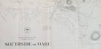
Southside of Oahu.
by [Hawaii: Oahu.] U.S. Navy.
- Used
- Condition
- Used
- Seller
-
Scarborough, Maine
- Item Price
-
$750.00$10.00 shipping to USA
Show Details
Item Price
$750.00
$10.00
shipping to USA
More Photos
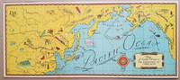
Map of Countries Visited in "Air Adventures of Jimmie Allen."
by [Pictorial Map: Asia and the Pacific.] Skelly Oil Co.
- Used
- Condition
- Used
- Seller
-
Scarborough, Maine
- Item Price
-
$495.00$10.00 shipping to USA
Show Details
Item Price
$495.00
$10.00
shipping to USA

More Photos
Newsmap, February 8, 1943. The World at War. Vol. 1, No. 42.
by [World War II.] U.S. Army, Army Orientation Course.
- Used
- Condition
- Used
- Seller
-
Scarborough, Maine
- Item Price
-
$295.00$10.00 shipping to USA
Show Details
Item Price
$295.00
$10.00
shipping to USA

More Photos
Sheriff Danny Arnold's Pictorial Map of The Old West showing pioneer trails and battles, Indian's territories, stagecoach lines, military forts, historical data of the frontier period around 1840.
by [Pictorial Map.] [Old West of the U.S.] Dowie, Fran.
- Used
- Condition
- Used
- Seller
-
Scarborough, Maine
- Item Price
-
$395.00$10.00 shipping to USA
Show Details
Item Price
$395.00
$10.00
shipping to USA
![Newsmap, Monday, 21 August 1944. [with map of] Philippine Islands.](https://d3525k1ryd2155.cloudfront.net/h/290/811/1497811290.0.m.jpg)
More Photos
Newsmap, Monday, 21 August 1944. [with map of] Philippine Islands.
by [World War II.] U.S. Army, Army Information Branch.
- Used
- Condition
- Used
- Seller
-
Scarborough, Maine
- Item Price
-
$295.00$10.00 shipping to USA
Show Details
Item Price
$295.00
$10.00
shipping to USA
