Description:
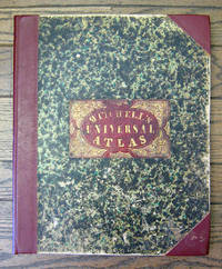
Philadelphia: S. Augustus Mitchell, 1849 Folio. (17 3/8 x 14 inches). Lithographed title with large vignette, letterpress "Table of Contents," and 73 hand-colored lithographed maps, charts and city plans. Three-quarter red morocco over marbled boards, large red morocco title label on front cover, elaborately tooled and lettered in gilt. Spine and corners renewed in red leather. Boards rubbed and scuffed at edges. Maps in fine condition. Overall, a fine copy. A very nice copy of this very scarce atlas, with hand-colored maps of all the individual States and Territories, and including the rare and famous map of "Oregon, Upper California & New Mexico" showing the large yellow-colored area in California labeled "Gold Region." The Atlas concentrates on the American continent with 43 maps of the area, including a fine double-page coast-to-coast map of the United States. Samuel Augustus Mitchell and his sons were the leading publishers of maps in the United States during…
Read More A NEW UNIVERSAL ATLAS CONTAINING MAPS OF THE VARIOUS EMPIRES, KINGDOMS, STATES AND REPUBLICS OF THE WORLD. WITH A SPECIAL MAP OF EACH OF THE UNITED STATES, PLANS OF CITIES, ETC. by Mitchell, Samuel Augustus - 1849
by Mitchell, Samuel Augustus
Similar copies are shown below.
Similar copies are shown to the right.

A NEW UNIVERSAL ATLAS CONTAINING MAPS OF THE VARIOUS EMPIRES, KINGDOMS, STATES AND REPUBLICS OF THE WORLD. WITH A SPECIAL MAP OF EACH OF THE UNITED STATES, PLANS OF CITIES, ETC.
by Mitchell, Samuel Augustus
- Used
Philadelphia: Mitchell, 1849. Folio atlas [17 1/2" x 13 1/2"]. Modern marbled bds with a modern gold stamped calf spine and new endpapers. Lithographic title page with large vignette, letterpress table of contents, hand colored frontis. of the heights of the principal mountains and lengths of the principal rivers. 72 hand colored lithographic maps, charts and city plans. Phillips Atlases 6104. Despite its title, the atlas gives much to the American continent with a total of 45 maps of the area. In 1846, Mitchell published his first edition of this atlas. He continued publishing his atlas to 1850, when he sold the rights to Cowperthwait and Co.
-
Bookseller
Michael Ginsberg Books
 (US)
(US)
- Book Condition Used
- Quantity Available 1
- Publisher Mitchell
- Place of Publication Philadelphia
- Date Published 1849
- Keywords WESTERN AMERICANA; MAPS; SOUTH
We have 1 copies available starting at $7,500.00.
More Photos
A New Universal Atlas Containing Maps of the various Empires, Kingdoms, State and Republics of the World. With a Special Map of each of the United States, Plans of Cities, &c.
by Mitchell, Samuel Augustus
- Used
- Hardcover
- first
- Condition
- Used
- Binding
- Hardcover
- Quantity Available
- 1
- Seller
-
San Francisco, California, United States
- Item Price
-
$7,500.00
Show Details
Item Price
$7,500.00