Description:
London: William Berry, 1680. ...Kingdoms, and States, which are found there at present/Described by Sanson/Corrected and amended By William Berry (=Kopftitel); Text der figürlich reich verzierten Kartusche oben rechts: Asia Divided into its Principall Regions in which may be seen the extent of the Empires Monarchies Kingdoms and States which at present divide Asia/To the Most serene and Most Sacred Majesty of Charles II./By the Grace of God King of Great Britain, France and Ireland/This Map of Asia is humbly Dedicated and Presented By Your Majesties Loyal Subject and Servand William Berry; Text der reich verzierten Kartusche links oben: Scale (es folgen Maßstäbe verschiedener Länder)/London/Sold by William Berry at the Sign of the Globe between Charing-Cross and White-Hall/1680; SW-Kupferstich-Landkarte nach (Nicolas) Sanson (d'Abbeville) gestochen von William Berry; ca. 51 x 39 cm; Falzspuren, einige Tintenflecken, hauptsächlich ausserhalb des Druckbildes, mässige…
Read More America Sive Novus Orbis Respectu Europaeorum Inferior Globi Terrestris Pars by De Bry - 1596: Map of America and USA
by De Bry

America Sive Novus Orbis Respectu Europaeorum Inferior Globi Terrestris Pars: Map of America and USA
by De Bry
- Used
"America Sive Novus Orbis Respectu Europaeorum Inferior Globi Terrestris Pars"
-Theodore De Bry
-Original Antique Print from 1596
-16x13 inches
-Very good condition. Professionally remargined.
Uncoloured. A few small repairs to rear.
Beautiful Original antique map of the Americas from Part 6 of De Bry's Grands Voyages and printed in 1596.
This large map depicts the Americas and Terra Australis, surrounded by full-length portraits of Columbus, Vespucci, Magellan and Pizarro. The map provides an accurate description of North and South America, which had only been discovered 100 years before this map was produced. The outlines of the continents are primarily derived from Plancius' 1594 map (which was included in Linschoten's Itinerario). The straits of Anian and an open North West Passage are depicted alongside the famed Terra Australis (named Magellanica on this map) which was presumed to exist at this time. The Solomon islands are shown, discovered in 1565 and an accurate depiction of Newfoundland, based on Claesz and Lasso. For the first time, the map includes information from White and Le Moyne's maps of Virginia and Florida (Parts 1 and 2 of De Bry's Grands Voyages).
De Bry's Grands Voyages was a 13 part compendium published from 1590 until the early 1600s. It was the first comprehensive work to describe the discovery Americas and remains a cornerstone of any collection of early Americana. Maps from the series are rare and highly desirable as they are some of the earliest available depictions of the Americas.
A beautiful, rare and highly detailed map of the Americas which would be a highlight of any collection of maps of the Americas or Pacific.
Please do not hesitate to contact me if you would like further information or if you are interested in other plates, works or maps by De Bry.
-
Seller
Independent bookstores
 (GB)
(GB)
- Illustrator Theodor De Bry
- Book Condition Used
- Quantity Available 1
- Publisher Theodor De Bry
- Place of Publication America / USA
- Date Published 1596
- Keywords America / USA

More Photos
Asia Distinguished in its Principall Parts uiz Turky in Asia, Arabia, Persia, India, China, Tartaria, The Islands of Japan, of the Philippines, of the Moluckes, of the Sundaes, of Ceylan, and of the Maldivies, where are set down the Empires, Monarchies...
by Sanson, (Nicolas)/Berry, William
- Used
- Condition
- Used - Gut
- Binding
- Unknown
- Quantity Available
- 1
- Seller
-
Velbert, Germany
- Item Price
-
$5,848.15
Show Details
Item Price
$5,848.15
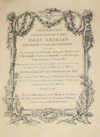
(History of Cartography, Geographic description of the Antilles): Description geographique des isles Antilles possédées par les Anglois
by Bellin, Jacques Nicolas
- Used
- very good
- Hardcover
- first
- Condition
- Used - Very Good
- Edition
- First Edition
- Binding
- Hardcover
- Quantity Available
- 1
- Seller
-
Crozet, Virginia, United States
- Item Price
-
$7,575.00
Show Details
Description:
A Paris: De l'imprimerie de Didot, 1758. This 10.5 inch quarto is in very good condition, sound hinges, 171 pp. with all 22 maps (several folding), plans and views in very good or better condition on heavy paper. Contemporary calf boards with original marbeled pastedowns, two title pages (one decorative with attribution to Bellin), "Tables des Titres" and "Table des Cartes, Plans et Vues." Six compartment, banded spine, with red, gilt title label.Triple (French), gilt fillets on front and rear boards. Bellin was the first chief hydrographic engineer of the French Hydrographic Office (see Tooley's Dictionary of Mapmakers, revised ed.). Ref: Beinecke, Lesser Antilles Collection, 215; Sabin 4553. This is an extremely nice copy.. First Edition. Full-Leather. Very Good.
Item Price
$7,575.00
More Photos
A Modern, Authentic and Complete System of Universal Geography
by Rev. Thomas Bankes
- Used
- very good
- Hardcover
- Condition
- Used - Very Good
- Binding
- Hardcover
- Quantity Available
- 1
- Seller
-
Farningham, Kent, United Kingdom
- Item Price
-
$4,370.46
Show Details
Description:
London: C.Cooke, 1793 Undated circa 1793. The content based on information received up until 1793. 6+990pp+2 - 88 plates, 22 maps. Whilst the scope purports to be the genuine history and description of the Whole World, such was the importance of Cook's discoveries that the first 106pp incorporating 25 plates and three maps is taken up with Cook's voyages. To this is included a particular description of the improved state of the New Colony formed at Port Jackson and Norfolk Island, where the convicts are now settled, and an account of the excursions and discoveries made in the interior parts of New Holland. Altogether this is a gargantuan production with stunning plates and maps. Contemporary full calf, superbly rebacked with the original spine relaid. Photographs available on request.
Item Price
$4,370.46
More Photos
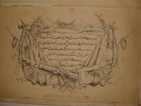
RARE OTTOMAN MILITARY MAP OF KARA DAG (MONT NEGRO)
by Ottoman General Staff Section
- Used
- very good
- Condition
- Used - Very Good
- Quantity Available
- 1
- Seller
-
Riyadh, Saudi Arabia
- Item Price
-
$5,000.00
Show Details
Description:
Istanbul: The general staff section, 1875 Map. Very Good. No Binding. Military map of Kara Dag (Mont Negro), Ottoman General staff section in 1291 (1875) after the map which made by the Austrian military geographical section in 1869 about Kara Dag and environs after the war and military movements of 1861-1862. Officially linen in colors by contemporary hands, 105 x 105 cm. Very rare..
Item Price
$5,000.00

More Photos
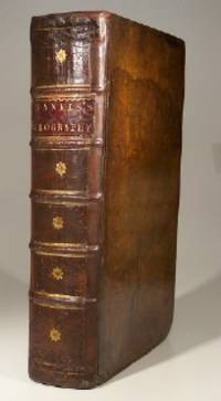
The Edinburgh Geographical and Historical Atlas
by John Hamilton
- Used
- Hardcover
- Condition
- Used - Very good +
- Binding
- Hardcover
- Quantity Available
- 1
- Seller
-
London, Ontario, Canada
- Item Price
-
$7,500.00
Show Details
Description:
Edinburgh: John Hamilton, ca. 1831. Leatherbound. Very good +. 16, 288, 4 p. 49 cm. 68 hand-coloured maps, many fold-out, and one fold-out of Mountain Chains with b&w engraving. Plate 32 missing as stipulated in Contents. Scales differ. Rebound in half leather by Keith Felton. Gilt trim. Original boards. Occasional dampstains and thumbing. Tear in fold of plate 61. Repairs to edges and corners of Contents page. Earlier repairs to edges of Table of Mountain Chains, Chart of the World, fold-out map of the Russian Empire. Title continues: "Comprehending A Sketch of the History of Geography; A View of the Principles of Mathematical, Physical, Civil, and Political Geography; An Account of the Geography, Statistics, and History of Each Continent, State, and Kingdom, Delineated. And a Tabular View of the Principal Mountain Chains in the World. Engraved on Sixty-nine Copperplates, and Compiled from Materials Drawn from the Newest and most Authentic Sources." This magnificent atlas was published about 1831…
Read More Item Price
$7,500.00
More Photos
Asia Distinguished in its Principall Parts uiz Turky in Asia, Arabia, Persia, India, China, Tartaria, The Islands of Japan, of the Philippines, of the Moluckes, of the Sundaes, of Ceylan, and of the Maldivies, where are set down the Empires, Monarchies...
by Sanson, (Nicolas)/Berry, William
- Used
- Condition
- Used - Gut
- Binding
- Unknown
- Quantity Available
- 1
- Seller
-
Velbert, Germany
- Item Price
-
$5,848.15
Show Details
Description:
London: William Berry, 1680. ...Kingdoms, and States, which are found there at present/Described by Sanson/Corrected and amended By William Berry (=Kopftitel); Text der figürlich reich verzierten Kartusche oben rechts: Asia Divided into its Principall Regions in which may be seen the extent of the Empires Monarchies Kingdoms and States which at present divide Asia/To the Most serene and Most Sacred Majesty of Charles II./By the Grace of God King of Great Britain, France and Ireland/This Map of Asia is humbly Dedicated and Presented By Your Majesties Loyal Subject and Servand William Berry; Text der reich verzierten Kartusche links oben: Scale (es folgen Maßstäbe verschiedener Länder)/London/Sold by William Berry at the Sign of the Globe between Charing-Cross and White-Hall/1680; SW-Kupferstich-Landkarte nach (Nicolas) Sanson (d'Abbeville) gestochen von William Berry; ca. 51 x 39 cm; Falzspuren, einige Tintenflecken, hauptsächlich ausserhalb des Druckbildes, mässige…
Read More Item Price
$5,848.15
More Photos
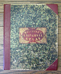
A New Universal Atlas Containing Maps of the various Empires, Kingdoms, State and Republics of the World. With a Special Map of each of the United States, Plans of Cities, &c.
by Mitchell, Samuel Augustus
- Used
- Hardcover
- first
- Condition
- Used
- Binding
- Hardcover
- Quantity Available
- 1
- Seller
-
San Francisco, California, United States
- Item Price
-
$7,500.00
Show Details
Description:
Philadelphia: S. Augustus Mitchell, 1849 Folio. (17 3/8 x 14 inches). Lithographed title with large vignette, letterpress "Table of Contents," and 73 hand-colored lithographed maps, charts and city plans. Three-quarter red morocco over marbled boards, large red morocco title label on front cover, elaborately tooled and lettered in gilt. Spine and corners renewed in red leather. Boards rubbed and scuffed at edges. Maps in fine condition. Overall, a fine copy. A very nice copy of this very scarce atlas, with hand-colored maps of all the individual States and Territories, and including the rare and famous map of "Oregon, Upper California & New Mexico" showing the large yellow-colored area in California labeled "Gold Region." The Atlas concentrates on the American continent with 43 maps of the area, including a fine double-page coast-to-coast map of the United States. Samuel Augustus Mitchell and his sons were the leading publishers of maps in the United States during…
Read More Item Price
$7,500.00
(History of Cartography, Geographic description of the Antilles): Description geographique des isles Antilles possédées par les Anglois
by Bellin, Jacques Nicolas
- Used
- very good
- Hardcover
- first
- Condition
- Used - Very Good
- Edition
- First Edition
- Binding
- Hardcover
- Quantity Available
- 1
- Seller
-
Crozet, Virginia, United States
- Item Price
-
$7,575.00
Show Details
Description:
A Paris: De l'imprimerie de Didot, 1758. This 10.5 inch quarto is in very good condition, sound hinges, 171 pp. with all 22 maps (several folding), plans and views in very good or better condition on heavy paper. Contemporary calf boards with original marbeled pastedowns, two title pages (one decorative with attribution to Bellin), "Tables des Titres" and "Table des Cartes, Plans et Vues." Six compartment, banded spine, with red, gilt title label.Triple (French), gilt fillets on front and rear boards. Bellin was the first chief hydrographic engineer of the French Hydrographic Office (see Tooley's Dictionary of Mapmakers, revised ed.). Ref: Beinecke, Lesser Antilles Collection, 215; Sabin 4553. This is an extremely nice copy.. First Edition. Full-Leather. Very Good.
Item Price
$7,575.00
More Photos
A Modern, Authentic and Complete System of Universal Geography
by Rev. Thomas Bankes
- Used
- very good
- Hardcover
- Condition
- Used - Very Good
- Binding
- Hardcover
- Quantity Available
- 1
- Seller
-
Farningham, Kent, United Kingdom
- Item Price
-
$4,370.46
Show Details
Description:
London: C.Cooke, 1793 Undated circa 1793. The content based on information received up until 1793. 6+990pp+2 - 88 plates, 22 maps. Whilst the scope purports to be the genuine history and description of the Whole World, such was the importance of Cook's discoveries that the first 106pp incorporating 25 plates and three maps is taken up with Cook's voyages. To this is included a particular description of the improved state of the New Colony formed at Port Jackson and Norfolk Island, where the convicts are now settled, and an account of the excursions and discoveries made in the interior parts of New Holland. Altogether this is a gargantuan production with stunning plates and maps. Contemporary full calf, superbly rebacked with the original spine relaid. Photographs available on request.
Item Price
$4,370.46
More Photos
The Edinburgh Geographical and Historical Atlas
by John Hamilton
- Used
- Hardcover
- Condition
- Used - Very good +
- Binding
- Hardcover
- Quantity Available
- 1
- Seller
-
London, Ontario, Canada
- Item Price
-
$7,500.00
Show Details
Description:
Edinburgh: John Hamilton, ca. 1831. Leatherbound. Very good +. 16, 288, 4 p. 49 cm. 68 hand-coloured maps, many fold-out, and one fold-out of Mountain Chains with b&w engraving. Plate 32 missing as stipulated in Contents. Scales differ. Rebound in half leather by Keith Felton. Gilt trim. Original boards. Occasional dampstains and thumbing. Tear in fold of plate 61. Repairs to edges and corners of Contents page. Earlier repairs to edges of Table of Mountain Chains, Chart of the World, fold-out map of the Russian Empire. Title continues: "Comprehending A Sketch of the History of Geography; A View of the Principles of Mathematical, Physical, Civil, and Political Geography; An Account of the Geography, Statistics, and History of Each Continent, State, and Kingdom, Delineated. And a Tabular View of the Principal Mountain Chains in the World. Engraved on Sixty-nine Copperplates, and Compiled from Materials Drawn from the Newest and most Authentic Sources." This magnificent atlas was published about 1831…
Read More Item Price
$7,500.00

Brevísima relación de la destrucción de las Indias (Clásicos Universales) (Spanish Edition)
by de las Casas, Fray Bartolomé; de Bry, Theodor [Illustrator]; Ramirez, Maritza [Foreword];
- Used
- Paperback
- Condition
- Used: Good
- Binding
- Paperback
- Quantity Available
- 1
- Seller
-
HOUSTON, Texas, United States
- Item Price
-
$13.65
Show Details
Description:
Independently published, 2019-09-17. Paperback. Used: Good.
Item Price
$13.65
Brevísima relación de la destrucción de las Indias (Clásicos Universales) (Spanish Edition)
by de las Casas, Fray Bartolomé; de Bry, Theodor [Illustrator]; Ramirez, Maritza [Foreword];
- Used
- Paperback
- Condition
- Used:Good
- Binding
- Paperback
- Quantity Available
- 1
- Seller
-
HOUSTON, Texas, United States
- Item Price
-
$13.65
Show Details
Description:
Independently published, 2019-09-17. Paperback. Used:Good.
Item Price
$13.65
A Briefe & True Report of the New Found Land of Virginia The Complete 1590 Theodor de Bry Edition
by Hariot, Thomas (Harriot) / Theodor de Bry (illusts.) / Paul Hulton (new intro.)
- Used
- Condition
- Used
- Quantity Available
- 1
- Seller
-
Sylva, North Carolina, United States
- Item Price
-
$10.00
Show Details
Description:
Dover, NY, c.1972, later prtg., 9"x12" paperbk., sewn binding, (xvii,91)pp., creased corner, VG- $
Item Price
$10.00
March of America Facsimile Series Number 15: Thomas Hariot's Virginia
by De Bry, Theodore
- Used
- good
- Hardcover
- Condition
- Used - Good
- Binding
- Hardcover
- Quantity Available
- 1
- Seller
-
South Lyon, Michigan, United States
- Item Price
-
$8.47
Show Details
Description:
University Microfilms, Inc, 1966-01-01. Hardcover. Good. Ann Arbor, 1966; blue cloth covered boards with gold cover titles and spine titles; some wear and rubbing to boards; 4to,9 3/4" to 12" tall; no jacket; sticker and pencil marking on front endpapers; mild foxing to endpapers and page edges. Additional shipping charges may need to be requested due to size or weight of book.
Item Price
$8.47

Le Livre des antipodes : Johann Ludwig Gottfried (La Découverte)
by Matthäus Merian, Jean Théodore de Bry, Helmut Andrä et Edgard de Cerqueira Falcão
- Used
- good
- Paperback
- Condition
- Used - Good
- Binding
- Paperback
- ISBN 10 / ISBN 13
- 9782707112323 / 2707112321
- Quantity Available
- 1
- Seller
-
Morangis, France
- Item Price
-
$5.42
Show Details
Description:
F. Maspero, 1981. Paperback. Good. Former library book. Slightly creased cover. Slight signs of wear on the cover. Soiling on the side. Ammareal gives back up to 15% of this book's net price to charity organizations.
Item Price
$5.42

Thomas Hariot's Virginia
by de Bry, Theodore
- Used
- very good
- Hardcover
- Condition
- Used - Very good
- Binding
- Hardcover
- Quantity Available
- 1
- Seller
-
Decatur, Georgia, United States
- Item Price
-
$15.00
Show Details
Description:
Ann Arbor: University Microfilms, 1966. Hardcover. Very good. Hardcover. Ink name on front free endpaper, else a very good hardback bound in publisher's blue cloth and issued without a jacket.
Item Price
$15.00
Model Sheets for Arts and Crafts: Johann Theodor de Bry's Neiw Kunstliches Alphabet, 1595
by Johann Theodor de Bry
- Used
- good
- Paperback
- Condition
- Used - Good
- Binding
- Paperback
- ISBN 10 / ISBN 13
- 9781934227084 / 1934227080
- Quantity Available
- 1
- Seller
-
HOUSTON, Texas, United States
- Item Price
-
$19.43
Show Details
Description:
Operina LLC, 2007-07-30. Paperback. Good.
Item Price
$19.43
Thomas Hariot's Virginia
by DE BRY, Theodore
- Used
- Hardcover
- Condition
- Used
- Binding
- Hardcover
- Quantity Available
- 1
- Seller
-
Ottawa, Ontario, Canada
- Item Price
-
$11.12
Show Details
Description:
Ann Arbor. University Microfilms, Inc. 1966. Hardcover. 28cm, unpaginated, previous owner's name on front free endpaper, original blue cloth with gilt titles, a fine copy (b1) March of America Facsimile Series.
Item Price
$11.12

Stock Photo: Cover May Be Different
Graphic Sketches From Old And Authentic Works, Illustrating The Costume, Habits, And Character, Of The Aborigines Of America : Together With Rare And Curious Fragments Relating To The Discovery And Se
by Theodor de Bry
- New
- Condition
- New
- ISBN 10 / ISBN 13
- 9789354509209 / 9354509207
- Quantity Available
- 210
- Seller
-
Uxbridge, Greater London, United Kingdom
- Item Price
-
$13.50
Show Details
Description:
New. New Book; Fast Shipping from UK; Not signed; Not First Edition; The Graphic Sketches From Old And Authentic Works, Illustrating The Costume, Habits, And Character, Of The Aborigines Of America : Together With Rare And Curious Fragments Relating To The Discovery And Se.
Item Price
$13.50

Iani Iacobi Boissardi vesvntini Emblematum liber (Latin Edition)
by Boissard, Jean Jacques; Bry, Theodor de
- Used
- Paperback
- Condition
- Like New
- Binding
- Paperback
- ISBN 10 / ISBN 13
- 9781175716521 / 1175716529
- Quantity Available
- 1
- Seller
-
Phoenix, Arizona, United States
- Item Price
-
$19.86
Show Details
Description:
Nabu Press, 2011-08-19. Paperback. Like New. 2011. Nabu Press. Trade Paperback. No marks. Appears unread. Ship same or next business day via US Mail. More Nabu Press books in my store. Matching ISBN.
Item Price
$19.86

More Photos
The Sky and the Forest
by Forester, C.S
- Used
- very good
- Hardcover
- first
- Condition
- Used - Very Good
- Jacket Condition
- Very Good
- Edition
- First Edition
- Binding
- Hardcover
- Quantity Available
- 1
- Seller
-
Salem, Oregon, United States
- Item Price
-
$34.89$20.93Save $13.96!
Show Details
Description:
C.S. Forester: The Sky and the Forest. Little, Brown and Company, Boston. Stated First Edition First Printing Thus August, 1948. Cover price $2.75. Used. VG BOOK/VG UNCLIPPED DUST JACKET. A story of a central Africa. By C.S. Forester, author of the Admiral Hornblower series.
Item Price
$34.89$20.93
Save $13.96
!
![Alaska and Klondike Region; [With inset of Klondike Region on the Upper Yukon detail] [From an...](https://d3525k1ryd2155.cloudfront.net/h/062/537/1339537062.0.m.jpg)
Alaska and Klondike Region; [With inset of Klondike Region on the Upper Yukon detail] [From an atlas, "Gazetteer of Alaska and Yukon Region " pp. 105 and 106]
by Miller, J. Martin
- Used
- very good
- Condition
- Used - Very Good
- Edition
- Unknown
- Quantity Available
- 1
- Seller
-
Sebastopol, California, United States
- Item Price
-
$39.00
Show Details
Description:
Chicago: J. Martin Miller, 1899. Unknown. Map. Very Good. [Map copyright 1899, printing date of Atlas later] [19.875x15.125in]; Colored map of Alaska with steamer routes from Portland and Seattle, insets of the Klondike Region on the Upper Yukon and Western portion of Aleutian Islands; On verso index of places and names with two large black and white images; Age toning to all edges, water stain marks on bottom, slight printing offset of colors, small chips and closed tears to lower edge;.
Item Price
$39.00

Zemepis Sveta - Monsunova Asie
by De La Blache, P. Vidal; Gallois, L
- Used
- Hardcover
- Condition
- Used - Very Good Condition
- Jacket Condition
- No Dust Jacket
- Binding
- Hardcover
- Quantity Available
- 1
- Seller
-
Oak Point, Texas, United States
- Item Price
-
$60.00
Show Details
Description:
Aventinum, Prague, Czechoslovakia, 1931. Hardcover. Very Good Condition/No Dust Jacket. Text entirely in Czech. Geography book on Asia with numerous photographs and maps. 1930 edition also available. Size: 4mo - over 9 3/4" - 12" tall. 400 pp. Pages are yellowed, but are tight and clean. Moderate shelfwear along the spine. Corners are lightly bumped. Quantity Available: 1. Shipped Weight: 3-5 pounds. Category: Travel & Places; Non-English Language::Czech; Pictures of this item not already displayed here available upon request. Inventory No: 001228. . Additional shipping charges may apply.
Item Price
$60.00

Zemepis Sveta - Monsunova Asie
by De La Blache, P. Vidal; Gallois, L
- Used
- Hardcover
- Condition
- Used - Very Good Condition
- Jacket Condition
- No Dust Jacket
- Binding
- Hardcover
- Quantity Available
- 1
- Seller
-
Oak Point, Texas, United States
- Item Price
-
$60.00
Show Details
Description:
Aventinum, Prague, Czechoslovakia, 1930. Hardcover. Very Good Condition/No Dust Jacket. Text entirely in Czech. Geography book on Asia with numerous photographs and maps. 1931 edition also available. Size: 4mo - over 9 3/4" - 12" tall. 400 pp. Pages are yellowed, but are tight and clean. Moderate shelfwear along the spine. Corners are lightly bumped. Quantity Available: 1. Shipped Weight: 3-5 pounds. Category: Travel & Places; Non-English Language::Czech; Pictures of this item not already displayed here available upon request. Inventory No: 001227. . Additional shipping charges may apply.
Item Price
$60.00

North America from the Best Authorities, Russell, ca.1800
by Russell
- Used
- Condition
- Used
- Quantity Available
- 1
- Seller
-
Plymouth, Devon, United Kingdom
- Item Price
-
$25.34
Show Details
Description:
Russell, J. : A General Map of North America from the Best Authorities. Nd but ca.1800. From "A New Geographical, Historical and Commercial Grammar and Present State of Several Kingdoms of the World." Copper engraving. Size approx 200 x 230mm. Two neat folds. Some age colouring to edges, otherwise very clean and bright.
Item Price
$25.34

Asia from the Best Authorities, Russell, ca.1800
by Russell
- Used
- Condition
- Used
- Quantity Available
- 1
- Seller
-
Plymouth, Devon, United Kingdom
- Item Price
-
$25.34
Show Details
Description:
Russell, J. : Asia from the Best Authorities. Nd but ca.1800. From "A New Geographical, Historical and Commercial Grammar and Present State of Several Kingdoms of the World". Copper engraving. Size approx 200 x 230mm. Two neat folds. Some age colouring to edges, otherwise clean and bright. Includes Arabia, India, Borneo, Japan, China and eastern Russia.
Item Price
$25.34
![MAP OF UTAH [Territory]](https://d3525k1ryd2155.cloudfront.net/h/836/461/1485461836.0.m.jpg)
More Photos
MAP OF UTAH [Territory]
- Used
- Condition
- Used - Very Good-
- Edition
- Original
- Quantity Available
- 1
- Seller
-
Williamsburg, Virginia, United States
- Item Price
-
$65.00
Show Details
Description:
New York, Richmond, Chicago, & Toledo: H. H. Hardesty, 1885. Original color lithographed map printed by Rand, McNally & Company, Engravers and published in HARDESTY'S HISTORICAL AND GEOGRAPHICAL ENCYCLOPEDIA: SPECIAL VIRGINIA EDITION. 19 3/8 inches by 13 1/4 inches on a 21" X 14 1/2" sheet. The map depicts the Territory of Utah in its final form--large areas had been removed and ceded to Nevada, Colorado, Wyoming, and Nebraska since Utah became a U. S. Territory in 1850. The issue of polygamy prevented statehood until it was finally granted in 1896. This map features railroads and topography and uses color to set off counties from each other. Unlike most atlas maps of the period, this map identifies most small towns. The map is guaranteed to be moe than 135 years old. The map is in about very good condition: generally clean and bright, with slight toning of paper and one faint water stain near the center-left edge of the map.. Original. Single Sheet. Very Good-. Elephant…
Read More Item Price
$65.00

Philips Special Map of the Nile, The Advance on Khartum and the Environs of Omdurman. Cc1900
by George Philips and Son,
- Used
- Condition
- Used
- Quantity Available
- 1
- Seller
-
Plymouth, Devon, United Kingdom
- Item Price
-
$32.94
Show Details
Description:
Philips Special map of the Nile illustrating the Advance on Khartum [Khartoum] with an enlargement of the environs of Omdurman [Omdur]. George Philips and Son, London and Liverpool Ca 1900. 580mm x 900mm folded map. Front title wrapper has come loose, not affecting map area. Three maps are displayed within the sheet. Map1. Map of the Nile Valley 520mm x 300mm showing the approaches of Khartum. Scale 1inch to 100 Geographical miles. Coloured indicating Possessions and Protectorates of European Powers. Map 2. Special map of the Nile from Dongola to Khartum. Scale 16 miles to the inch. Coloured. In set in this map is Map3. Environs of Omdurman, Scale 5 statute miles to the inch. Some small breaks at some folds, not affecting imagery or use of map. Title label is damaged, the map is clean and bright, probably unused. A very interesting record.
Item Price
$32.94

Last Tales
by Dinesen, Isak
- Used
- very good
- Hardcover
- first
- Condition
- Used - Very Good
- Jacket Condition
- Good+
- Edition
- First Edition
- Binding
- Hardcover
- Quantity Available
- 1
- Seller
-
Salem, Oregon, United States
- Item Price
-
$120.00$72.00Save $48.00!
Show Details
Description:
Dinesen, Isak: Last Tales, A Collection of Twelve New Tales of Compelling Beauty 1957, Random House. First Edition. Stated First Printing Thus. Used. Very Good/Good+ original red dust jacket, price-clipped. Jacket states 11/57 on front flap. 5 3/4 X
Item Price
$120.00$72.00
Save $48.00
!

The Adventure of Wrangel Island
by Vilhjalmur Stefansson
- Used
- good
- Hardcover
- first
- Condition
- Used - Good
- Jacket Condition
- No DJ Included
- Edition
- First Edition
- Binding
- Hardcover
- Quantity Available
- 1
- Seller
-
Salem, Oregon, United States
- Item Price
-
$124.89$74.93Save $49.96!
Show Details
Description:
The Adventure of Wrangel Island, Alaska (1925 Macmillan 1st Edition) HISTORY OF ALASKA. EXLIB. Good Condition/ No DJ included. Fold-out map affixed to binding at the back of the book has never been opened. The story of the (unsuccessful) attempted colonization of Wrangel Island Alaska. 413 pages plus appendix, Index. Titling is still bright. A clean, solid copy. Scarce.
Item Price
$124.89$74.93
Save $49.96
!