
Click for full-size.
New Topographical Atlas and Gazetteer of Indiana, Comprising a Topographical View of the Several Counties of the State, Together with a Railroad Map of Ohio, Indiana, and Illinois, an Alphabetical Gazetteer ...
by Geo. H. Adams & Co
- Used
- Hardcover
- Condition
- Fair with no dust jacket
- Seller
-
Bloomington, Indiana, United States
Payment Methods Accepted
About This Item
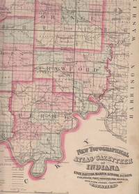
NY & Indianapolis. NY & Indianapolis: Geo. H. Adams & Co.. Fair with no dust jacket. 1871. Hardcover. Brown cloth boards with red leather corners and spine. Covers are heavily worn, stained, lacking top inch of backstrip. Book is shaken, but binding is still fairly firm except at the top three or four inches where it is loosening. Pages are all present and attached, but soiled, varmint-gnawed at extremities of first several pages, small chips and tears. The pastedowns are loosening from the boards, and the last endpaper has a long tear. Some pages have owners' names and other marks and doodling, foxing, some creasing. Most of the soil, staining, and foxing is at the margins of pages. All pages are present and all text and illustrations are easily readable. Page 30 has been clumsily removed by someone and pasted to p. 13 (the blank verso of p. 12). . The title continues: "Gazetteer, giving a concise description and the location of cities, villages, post offices, railroad stations, landings, etc. , and a brief history of Indiana. " Book was copyrighted by Asher, Adans & Higgins, 1870. It contains detailed county maps of each of the counties of Indiana, showing county seats, towns and post offices, state and county roads, railroads, canals, county boundaries, civil township boundaries, congressional districts, and geological survey boundaries. In addition, there is a two-page map of the midwest states showing railroad lines (named) and counties. Following the atlas pages is a history of Indiana, focusing on geography, geology, and natural history. A paragraph is then devoted to each of the Indiana counties, again with a focus on geography, geology, and natural history. A gazetteer follows, with a county, description, and location provided for each named place. The 1870 population of Indiana counties, cities and towns is given in two tables. Bloomington, Indiana had a population of 1,840 in 1870, while the populations of Lafayette and Indianapolis were 14,312 and 41,604 respectively. Finally, the principal producers, patrons of the state atlas and gazetteer, and business directories for three counties are given: Monroe, Lawrence, and Jackson. The Business Directory for Bloomington lists by name nine attorneys, seven faculty members at Indiana University, seven boarding houses, three tanners and curriers, two saddle and harness makers, and a woollen mill, among much else. This is not a pretty book, but it is complete and fairly solid, and it contains a wealth of information about the state of Indiana immediately following the end of the Civil War. . Folio 13" - 23" tall. H0 .
Reviews
(Log in or Create an Account first!)
Details
- Bookseller
- Sweet Beagle Books
 (US)
(US)
- Bookseller's Inventory #
- 22525
- Title
- New Topographical Atlas and Gazetteer of Indiana, Comprising a Topographical View of the Several Counties of the State, Together with a Railroad Map of Ohio, Indiana, and Illinois, an Alphabetical Gazetteer ...
- Author
- Geo. H. Adams & Co
- Format/Binding
- Hardcover
- Book Condition
- Used - Fair with no dust jacket
- Publisher
- Geo. H. Adams & Co.
- Place of Publication
- NY & Indianapolis. NY & Indianapolis
- Date Published
- 1871
- Keywords
- Indiana History, Gazetteer, Atlas, 1870s
- Bookseller catalogs
- Indiana; Travel and Geography; Trains and Railroading; History, US / Indiana; Science / Geology;
Terms of Sale
Sweet Beagle Books
All books are well-protected with packing materials and shipped in a sturdy box. Shipments to locations in the U.S. include Delivery Confirmation. Packages to locations outside the U.S. are shipped well-padded in cardboard Global Priority flat-rate envelopes whenever possible.
Any book may be returned within 10 days for any reason, with prior email notice, for a full refund of the book's price. Condition of returns must be the same as when shipped. Cost of return postage will be paid by the customer, and book must be packed appropriately so that damage does not occur in the return shipment.
About the Seller
Sweet Beagle Books
Biblio member since 2003
Bloomington, Indiana
About Sweet Beagle Books
SWEET BEAGLE BOOKS is strictly an online company (no bricks and mortar) with thousands of classic, collector editions, out-of-print and rare books. Nearly all items we list are in very good to fine condition, with the few exceptions noted in the item descriptions.
Glossary
Some terminology that may be used in this description includes:
- Jacket
- Sometimes used as another term for dust jacket, a protective and often decorative wrapper, usually made of paper which wraps...
- Verso
- The page bound on the left side of a book, opposite to the recto page.
- Spine
- The outer portion of a book which covers the actual binding. The spine usually faces outward when a book is placed on a shelf....
- Folio
- A folio usually indicates a large book size of 15" in height or larger when used in the context of a book description. Further,...
- Shaken
- A hardcover in which the text block is loose, but still attached to the binding.
- Soiled
- Generally refers to minor discoloration or staining.
- Cloth
- "Cloth-bound" generally refers to a hardcover book with cloth covering the outside of the book covers. The cloth is stretched...
- Fair
- is a worn book that has complete text pages (including those with maps or plates) but may lack endpapers, half-title, etc....
This Book’s Categories

May the Fourth Be With You!
As the Star Wars franchise continues to grow, change, and churn out money-making film after film now under the control of Disney, we can bet that the desire to own Star Wars collectibles will also continue to grow. Check out our gallery of goodies from a galaxy far, far away...
Collecting the 1939 New York World’s Fair
Born in the midst of the Great Depression, the theme of the 1939 World’s Fair was “The World of Tomorrow” - a theme that captured the hearts of a generation. Check out the maps, souvenirs, and other ephemera on Biblio!