WELLS AND FROME; Ordinance Survey Contoured Road Map of Popular Edition, One Inch to One Mile
- Used
- very good
- Paperback
- Condition
- Very Good
- Seller
-
Fredericton, New Brunswick, Canada
Payment Methods Accepted
About This Item
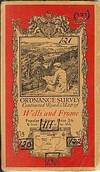
Southampton: Ordinance Survey Office Book. Very Good. Paperbound. Sheet 121, printed 1919, revision of 1913, Roads to 1932,Minor Corrections to 1933, Print Code 2000/34,300/36, original price 2/6,with red, Ellis Martin designed pict. wraps,incorporating map, this series was printed in the interval between WWI &WWII (1918-1933) previous owner has noted numbers of contigious maps in all directions in ink, (see scan) minor toning ,some light edge chips, else, clean, bright.
Reviews
(Log in or Create an Account first!)
Details
- Bookseller
- Harry E Bagley Books Ltd
 (CA)
(CA)
- Bookseller's Inventory #
- 123044
- Title
- WELLS AND FROME; Ordinance Survey Contoured Road Map of Popular Edition, One Inch to One Mile
- Format/Binding
- Paperback
- Book Condition
- Used - Very Good
- Publisher
- Ordinance Survey Office
- Place of Publication
- Southampton
- Keywords
- MAPA BRITISH ISLES ORDINANCE SURVEY WELLS AND FROME CARTOGRAPHY MAPPING SURVEYING ENGLAND ENGLISH MAPS ELLIS MARTIN
- Bookseller catalogs
- Maps;
Terms of Sale
Harry E Bagley Books Ltd
Returnable upon receipt with prior notification. If paying by check, please allow two weeks for clearance.
About the Seller
Harry E Bagley Books Ltd
Biblio member since 2004
Fredericton, New Brunswick
About Harry E Bagley Books Ltd
Mail order only. 51 years as a bookseller

How to tell if a signature is genuine
Author's signatures can undoubtedly increase the value of a rare book or first edition. The more scarce the book is, the more an autograph adds to its value. But how to tell if the signature is real? Find out how you can avoid common pitfalls in identifying an author's signature.

Collecting Disneyana
Welcome to the wonderful world of collecting Walt Disney! From letters signed by Disney himself to classic children’s books or ephemera, be sure to check out some of the collectible Walt Disney books on Biblio!