Description:
New York: F. W. Beers, 1873. First Edition . Disbound. Fair/No Dust Jacket. Folio. Five sheets ONLY, disbound from a damaged and incomplete 1873 "Atlas of Douglas Co. Kansas." This Lawrence section is complete on the five sheets (pp: 23-38). One map is a single page, and the other four are double pages with at least one side folding. Each is approx. 15 inches in height. Moderate edge wear, with a couple tears entering the border along the upper edge of the last sheet. These last tears are roughly closed along about one inch of the folds, though there is also a little paper loss just a little lower on one fold. The first maps sheet also shows a couple small spots of paper loss along one fold. Overall, however, the images are intact and clear. At the time of this listing, WorldCat shows only seven copies and there are no auction records for this atlas.
MAP: Nova Europae Descriptio by Hondius, Jodocus - 1628
by Hondius, Jodocus

MAP: Nova Europae Descriptio
by Hondius, Jodocus
- Used
Amsterdam, 1628 >>FRAMED AND GLAZED (UV-Blocking Non Glare)<< / Splendid, large copper engraving map, coloured, Mercator, Amsterdam by Jodocus Hondius 1628 [Atlas sive Cosmographicae Meditiones] Map of Europe "Nova Europae Descriptio..." CARTOGRAPHER: Gerard Mercator (1512-1594) Mercator was a Belgian cartographer. Jodocus Hondius (1563-1612), sometimes called Jodocus Hondius the Elder to distinguish him from his son) was a Flemish artist, engraver, and cartographer. He is best known for his early maps of the New World and Europe, for re-establishing the reputation of the work of Gerard Mercator, and for his portraits of Francis Drake. He helped established Amsterdam as the center of cartography in Europe in the 17th century. DESCRIPTION: This is a large, wonderful coloured copper engraving map of Mercator by Hondius. It shows Europe for example with Scandinavia, Benelux, Germany, France, Spain, Italy. The map is decorated with a beautiful title cartouche. A very beautiful map. // Size of leaf appr.: 44.2 x 53.2 cm // Size of map appr.: 37.5 x 50.1 cm. If you want to receive the frame with the map. ask for a shipping quote. PHOTOS AVAILABLE UPON REQUEST.
-
Bookseller
Independent bookstores
 (CA)
(CA)
- Format/Binding No Binding
- Book Condition Used - Very Good Condition
- Quantity Available 1
- Place of Publication Amsterdam
- Date Published 1628
- Size Map: 37,5cm x 50,1cm
- Keywords Map, Carte G�ographique, Livres du XVII�me
- Size Map: 37,5cm x 50,1cm
![[Map] "City Of Lawrence," from Atlas of Douglas Co. Kansas. [Five Map Sheets,...](https://d3525k1ryd2155.cloudfront.net/h/451/955/919955451.0.m.jpg)
More Photos
[Map] "City Of Lawrence," from Atlas of Douglas Co. Kansas. [Five Map Sheets, Comprising Pages 23-38 ONLY]
- Used
- fair
- first
- Condition
- Used - Fair
- Jacket Condition
- No Dust Jacket
- Edition
- First Edition
- Binding
- Unknown
- Quantity Available
- 1
- Seller
-
Chanute, Kansas, United States
- Item Price
-
$1,500.00
Show Details
Item Price
$1,500.00

More Photos
A System of Geography: or, A New & Accurate Description of the Earth in all its Empires, Kingdoms and States. Illustrated with History and Topography and Maps of every Country. Fairly engraven on copper, according to the latest discoveries and Corrections
by Moll, Herman and Rober Falconer
- Used
- first
- Condition
- Used
- Edition
- First Edition
- Binding
- Unknown
- Quantity Available
- 1
- Seller
-
Scottsdale, Arizona, United States
- Item Price
-
$1,875.00
Show Details
Description:
London: For A. and J. Churchil and T. Childe, 1701. First Edition. Folio. From the library of John, Earl of Loudoun (John Campbell, Fourth Earl of Loudoun (5 May 1705 - 27 Apr. 1782) In 1727, Campbell entered the Army. He was commissioned major general in 1755, and appointed the following year as commander-in-chief of British forces in America during the French and Indian War, and named titular governor of Virginia. Variant issue, with both Churchil & Childe in imprint, 2 parts in 1 volume. Frontispiece, title page in red and black, 4; [24] contents, 444pp; 1-230; [28]pp. index. While the collation is haphazard, the book itself is complete with all catchwords matching, (with dupicate 125 pagination as in all copies) Frontispiece, 2 Engravings of Ptolomei and Copernici systems; 2 engraved compasses; and 44 textual maps, (45 maps if one counts the small china strip map).Contains the following maps. 1. Earth 2. Europe 3. Britain 4.Scotland 5. Ireland 6. France 7. Netherlands 8. United…
Read More Item Price
$1,875.00

More Photos
Travels in the Interior Districts of Africa: Performed under the direction and patronage of the african association, in the years 1795, 1796, and 1797. with an appendix, containing illustrations of Africa by Major Rennel
by PARK, Mungo
- Used
- very good
- Hardcover
- Condition
- Used - Very Good
- Edition
- 2nd
- Binding
- Hardcover
- Quantity Available
- 1
- Seller
-
Cuernavaca, Morelos, Mexico
- Item Price
-
$1,590.00
Show Details
Description:
London, W.Bulmer and Co., 17994º. xxviii,(2),372 pp., xcii. Bound to style in a fine later calf. Title-and tomelabels with gilt lettering. Blindtoolings to bands and compartments of spine. Engraved portrait as frontispiece, 2 engraved plates with music, 5 engraved plates (of which 3 are views) and 3 large folded engraved maps. One map strenghtened in foldings and edges, one map with a closed tear to folding. Wide-margined, a few margins slightly brownspotted. Light offsetting to title and portrait.
Second edition - the same year as the first - of this classic work of travel litterature.
"Until the publicationof Park's book in 1799 hardly anything was known of the interior of Africa, apart from the north-east region and coastal areas....the real opening up of Africa by the white races began with the African Association, founded in 1788 with the express purpose of exploring Africa and furthering British tradee and political influence onthe continent...Parks travels had an immediate success and was… Read More
Item Price
$1,590.00
More Photos
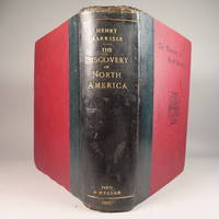
The Discovery of North America, A Critical, Documentary, and Historic Investigation,: with an essay on the early cartography of the New World, including descriptions of two hundred and fifty maps or globes existing or lost, constructed before the year 1536...
by Henry Harrisse
- Used
- very good
- Hardcover
- first
- Condition
- Used - Very Good
- Edition
- First Edition
- Binding
- Hardcover
- Quantity Available
- 1
- Seller
-
Fort Lauderdale, Florida, United States
- Item Price
-
$1,450.00
Show Details
Description:
Quarter morocco over pictorial maroon cloth board with gilt particulars to spine. Top edge gilt. Limited edition copy No. 91 of 380 issued, this being the English Toned Paper edition. Hors textes plates with tissue guards throughout. Black and white illustrations throughout text as well. Title continued: "to which are added a chronology of one hundred voyages westward, projected, attempted, or accomplished between 1431 and 1504; biographical accounts of the three hundred pilots who first crossed the Atlantic; and a copious list of the original names of American regions, caciqueships, mountains, islands, capes, gulfs, rivers, towns, and harbours." Topics include: John Cabot, Gaspar Corte-Real, Christopher Columbus, Ancient Maps, First Knowledge of Florida, Colonisation [colonization] of Nova Scotia, Aliminos, Pardon Real, Lusitano-Germanic Cartography, and much more. Wear to head of spine and hinges, but still intact and sturdy. 802 pp. 9 3/4 x 11 3/4. A clean, bright volume without previous owners'…
Read More Item Price
$1,450.00
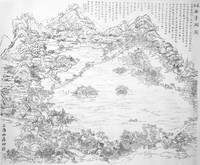
Map - 'The Latest Plan of the West Lake'
by Anon.
- Used
- Condition
- Used
- Binding
- Unknown
- Quantity Available
- 1
- Seller
-
Trinity TB, Newfoundland, Canada
- Item Price
-
$1,500.00
Show Details
Description:
Er You Mountain Publishing House, 1917. The West Lake area, near Hangzhou, Zhejiang Province, China, has been valued as a destination for travellers seeking outstanding scenic beauty since the 9th century. The subject of numerous classical paintings, literature and poetry, it has welcomed scholars, pilgrims, philosophers, monks and foreign envoys for over a thousand years. Many sojourners have left their mark in the form of numerous gardens, temples and pagodas constructed over the intervening centuries. In 2011, UNESCO declared the Lake and its surrounds a World Heritage Site, stating at the time that "The West Lake has influenced garden design in the rest of China as well as Japan and Korea over the centuries and bears an exceptional testimony to the cultural tradition of improving landscapes to create a series of vistas reflecting an idealised fusion between humans and nature." The present map, a large scale woodblock print, dated 7th year of the Republican era (1917), illustrates and…
Read More Item Price
$1,500.00

(Map of colonial northeastern Canada): Partie Orientale de la Nouvelle France ou du Canada...Terre-Neuve...Nouvelle Ecosse Acadie...T. Conrad Lotter Graveur et Geogr
by Lotter, Conrad (Seutter, Albrecht Carl)
- Used
- Condition
- Used
- Binding
- Unknown
- Quantity Available
- 1
- Seller
-
Crozet, Virginia, United States
- Item Price
-
$1,895.00
Show Details
Description:
Augusburg: Tobias Conrad Lotter and Albrecht Karl Seutter, 1756. Very good copperplate engraving with a right marginal tear not affecting image, repaired verso with archival tape. Some restoration to left margin (not affecting main image), and entire map backed with archival paper. Strong image. Small embossed stamp left lower margin (faint), with attribution to Seutter in left lower margin just below neatline. The date is approximate, and predicated on Lotter's partnership with Seutter from 1756-62. Earlier states appeared in a number of Seutter atlases. Ref: McCorkle, New England in Printed Maps, entry 730.4, p. 90. The image depicts an area from parts of Labrador to Nova Scotia. The map has outline and minimal wash color, with an elaborate, allegorical cartouche. Lotter was Seutter's son-in-law. The map image measures 58 x 50 cm..
Item Price
$1,895.00
More Photos
[Map] "City Of Lawrence," from Atlas of Douglas Co. Kansas. [Five Map Sheets, Comprising Pages 23-38 ONLY]
- Used
- fair
- first
- Condition
- Used - Fair
- Jacket Condition
- No Dust Jacket
- Edition
- First Edition
- Binding
- Unknown
- Quantity Available
- 1
- Seller
-
Chanute, Kansas, United States
- Item Price
-
$1,500.00
Show Details
Description:
New York: F. W. Beers, 1873. First Edition . Disbound. Fair/No Dust Jacket. Folio. Five sheets ONLY, disbound from a damaged and incomplete 1873 "Atlas of Douglas Co. Kansas." This Lawrence section is complete on the five sheets (pp: 23-38). One map is a single page, and the other four are double pages with at least one side folding. Each is approx. 15 inches in height. Moderate edge wear, with a couple tears entering the border along the upper edge of the last sheet. These last tears are roughly closed along about one inch of the folds, though there is also a little paper loss just a little lower on one fold. The first maps sheet also shows a couple small spots of paper loss along one fold. Overall, however, the images are intact and clear. At the time of this listing, WorldCat shows only seven copies and there are no auction records for this atlas.
Item Price
$1,500.00
More Photos
Travels in the Interior Districts of Africa: Performed under the direction and patronage of the african association, in the years 1795, 1796, and 1797. with an appendix, containing illustrations of Africa by Major Rennel
by PARK, Mungo
- Used
- very good
- Hardcover
- Condition
- Used - Very Good
- Edition
- 2nd
- Binding
- Hardcover
- Quantity Available
- 1
- Seller
-
Cuernavaca, Morelos, Mexico
- Item Price
-
$1,590.00
Show Details
Description:
London, W.Bulmer and Co., 17994º. xxviii,(2),372 pp., xcii. Bound to style in a fine later calf. Title-and tomelabels with gilt lettering. Blindtoolings to bands and compartments of spine. Engraved portrait as frontispiece, 2 engraved plates with music, 5 engraved plates (of which 3 are views) and 3 large folded engraved maps. One map strenghtened in foldings and edges, one map with a closed tear to folding. Wide-margined, a few margins slightly brownspotted. Light offsetting to title and portrait.
Second edition - the same year as the first - of this classic work of travel litterature.
"Until the publicationof Park's book in 1799 hardly anything was known of the interior of Africa, apart from the north-east region and coastal areas....the real opening up of Africa by the white races began with the African Association, founded in 1788 with the express purpose of exploring Africa and furthering British tradee and political influence onthe continent...Parks travels had an immediate success and was… Read More
Item Price
$1,590.00
More Photos
The Discovery of North America, A Critical, Documentary, and Historic Investigation,: with an essay on the early cartography of the New World, including descriptions of two hundred and fifty maps or globes existing or lost, constructed before the year 1536...
by Henry Harrisse
- Used
- very good
- Hardcover
- first
- Condition
- Used - Very Good
- Edition
- First Edition
- Binding
- Hardcover
- Quantity Available
- 1
- Seller
-
Fort Lauderdale, Florida, United States
- Item Price
-
$1,450.00
Show Details
Description:
Quarter morocco over pictorial maroon cloth board with gilt particulars to spine. Top edge gilt. Limited edition copy No. 91 of 380 issued, this being the English Toned Paper edition. Hors textes plates with tissue guards throughout. Black and white illustrations throughout text as well. Title continued: "to which are added a chronology of one hundred voyages westward, projected, attempted, or accomplished between 1431 and 1504; biographical accounts of the three hundred pilots who first crossed the Atlantic; and a copious list of the original names of American regions, caciqueships, mountains, islands, capes, gulfs, rivers, towns, and harbours." Topics include: John Cabot, Gaspar Corte-Real, Christopher Columbus, Ancient Maps, First Knowledge of Florida, Colonisation [colonization] of Nova Scotia, Aliminos, Pardon Real, Lusitano-Germanic Cartography, and much more. Wear to head of spine and hinges, but still intact and sturdy. 802 pp. 9 3/4 x 11 3/4. A clean, bright volume without previous owners'…
Read More Item Price
$1,450.00
Map - 'The Latest Plan of the West Lake'
by Anon.
- Used
- Condition
- Used
- Binding
- Unknown
- Quantity Available
- 1
- Seller
-
Trinity TB, Newfoundland, Canada
- Item Price
-
$1,500.00
Show Details
Description:
Er You Mountain Publishing House, 1917. The West Lake area, near Hangzhou, Zhejiang Province, China, has been valued as a destination for travellers seeking outstanding scenic beauty since the 9th century. The subject of numerous classical paintings, literature and poetry, it has welcomed scholars, pilgrims, philosophers, monks and foreign envoys for over a thousand years. Many sojourners have left their mark in the form of numerous gardens, temples and pagodas constructed over the intervening centuries. In 2011, UNESCO declared the Lake and its surrounds a World Heritage Site, stating at the time that "The West Lake has influenced garden design in the rest of China as well as Japan and Korea over the centuries and bears an exceptional testimony to the cultural tradition of improving landscapes to create a series of vistas reflecting an idealised fusion between humans and nature." The present map, a large scale woodblock print, dated 7th year of the Republican era (1917), illustrates and…
Read More Item Price
$1,500.00

Imago Mundi: A Review of Early Cartography Supplement No. V
by Jodocus Hondius and Petrus Kaerius
- Used
- Condition
- Used - Good
- Quantity Available
- 1
- Seller
-
Frederick, Maryland, United States
- Item Price
-
$15.40
Show Details
Description:
Amsterdam N. Israel. Used - Good. Good condition. Supplement No. V. (Early Cartography, History, European maps) A copy that has been read but remains intact. May contain markings such as bookplates, stamps, limited notes and highlighting, or a few light stains.
Item Price
$15.40

Stock Photo: Cover May Be Different
Map Of The World, By Jodocus Hondius, 1611 (1907)
by Jodocus Hondius, Edward Luther Stevenson (Editor), Joseph Fischer (Editor)
- Used
- Paperback
- Condition
- Used:Good
- Binding
- Paperback
- ISBN 10 / ISBN 13
- 9780548767870 / 0548767874
- Quantity Available
- 1
- Seller
-
HOUSTON, Texas, United States
- Item Price
-
$20.73
Show Details
Description:
Kessinger Publishing, LLC, 2007-11-10. Paperback. Used:Good.
Item Price
$20.73
Stock Photo: Cover May Be Different
Map Of The World, By Jodocus Hondius, 1611 (1907)
by Jodocus Hondius; Editor-Edward Luther Stevenson; Editor-Joseph Fischer
- Used
- good
- Paperback
- Condition
- Used - Good
- Binding
- Paperback
- ISBN 10 / ISBN 13
- 9780548767870 / 0548767874
- Quantity Available
- 1
- Seller
-
HOUSTON, Texas, United States
- Item Price
-
$20.73
Show Details
Description:
Kessinger Publishing, LLC, 2007-11-10. Paperback. Good.
Item Price
$20.73
Map Of The World
by Jodocus Hondius
- New
- Paperback
- Condition
- New
- Binding
- Paperback
- ISBN 10 / ISBN 13
- 9781018279831 / 1018279830
- Quantity Available
- 10
- Seller
-
Southport, Merseyside, United Kingdom
- Item Price
-
$16.48
Show Details
Description:
Paperback / softback. New.
Item Price
$16.48

The World Map of 1669
by Hondius, Jodocus
- Used
- Fine
- Paperback
- Condition
- Used - Fine
- Binding
- Paperback
- ISBN 10 / ISBN 13
- 9789060721193 / 9060721195
- Quantity Available
- 3
- Seller
-
Bloomington, Illinois, United States
- Item Price
-
$25.00
Show Details
Description:
Amsterdam: Nico Israel Da Capo Press. Fine. 1978. Softcover. Folio. We specialize in fine books in collectible condition. Orders are professionaly packaged and shipped promptly. M23 .
Item Price
$25.00

Stock Photo: Cover May Be Different
Map of the World by Jodocus Hondius, 1611;; text
by Jodocus 1563-1612 Hondius
- New
- Paperback
- Condition
- New
- Binding
- Paperback
- ISBN 10 / ISBN 13
- 9781014808523 / 1014808529
- Quantity Available
- 10
- Seller
-
Southport, Merseyside, United Kingdom
- Item Price
-
$17.66
Show Details
Description:
Paperback / softback. New.
Item Price
$17.66
Stock Photo: Cover May Be Different
Map Of The World, By Jodocus Hondius, 1611 (1907)
by Hondius, Jodocus
- New
- Condition
- New
- ISBN 10 / ISBN 13
- 9780548767870 / 0548767874
- Quantity Available
- 10
- Seller
-
Southport, Merseyside, United Kingdom
- Item Price
-
$18.25
Show Details
Description:
New.
Item Price
$18.25
Map Of The World
by Jodocus Hondius
- New
- Paperback
- Condition
- New
- Binding
- Paperback
- ISBN 10 / ISBN 13
- 9781018279831 / 1018279830
- Quantity Available
- 10
- Seller
-
Southport, Merseyside, United Kingdom
- Item Price
-
$20.84
Show Details
Description:
Paperback / softback. New.
Item Price
$20.84

A Clear Description of the Cape of Good Hope - Klare besgryving van Cabo De Bona Esperanca
by Hondius, Jodocus
- Used
- very good
- Hardcover
- Condition
- Used - Very Good
- Jacket Condition
- No Jacket
- Binding
- Hardcover
- Quantity Available
- 1
- Seller
-
Johannesburg, South Africa
- Item Price
-
$12.00
Show Details
Description:
Jodocus Hondius, 1952. Hardcover. Very Good/No Jacket. The boards are in a very good condition, except for some minor marks. Internally clean and tightly bound. Complete with 37 pages. English and partly Afrikaans language. [B.K.]. Our orders are shipped using tracked courier delivery services.
Item Price
$12.00
Stock Photo: Cover May Be Different
Map of the World by Jodocus Hondius, 1611;; text
by Jodocus 1563-1612 Hondius
- New
- Paperback
- Condition
- New
- Binding
- Paperback
- ISBN 10 / ISBN 13
- 9781014808523 / 1014808529
- Quantity Available
- 10
- Seller
-
Southport, Merseyside, United Kingdom
- Item Price
-
$22.19
Show Details
Description:
Paperback / softback. New.
Item Price
$22.19

More Photos
The Sky and the Forest
by Forester, C.S
- Used
- very good
- Hardcover
- first
- Condition
- Used - Very Good
- Jacket Condition
- Very Good
- Edition
- First Edition
- Binding
- Hardcover
- Quantity Available
- 1
- Seller
-
Salem, Oregon, United States
- Item Price
-
$34.89$17.45Save $17.44!
Show Details
Description:
C.S. Forester: The Sky and the Forest. Little, Brown and Company, Boston. Stated First Edition First Printing Thus August, 1948. Cover price $2.75. Used. VG BOOK/VG UNCLIPPED DUST JACKET. A story of a central Africa. By C.S. Forester, author of the Admiral Hornblower series.
Item Price
$34.89$17.45
Save $17.44
!

More Photos
Plat Book: Pierce County, Wisconsin
by Rhame, A. E
- Used
- Fine
- Paperback
- Condition
- Used - Fine
- Binding
- Paperback
- Quantity Available
- 1
- Seller
-
Woodruff, Wisconsin, United States
- Item Price
-
$46.66
Show Details
Description:
1930. Soft Cover. Fine. Unpaginated. Tan colored book is in Fine condition, no sign of wear.
Item Price
$46.66
![Alaska and Klondike Region; [With inset of Klondike Region on the Upper Yukon detail] [From an...](https://d3525k1ryd2155.cloudfront.net/h/062/537/1339537062.0.m.jpg)
Alaska and Klondike Region; [With inset of Klondike Region on the Upper Yukon detail] [From an atlas, "Gazetteer of Alaska and Yukon Region " pp. 105 and 106]
by Miller, J. Martin
- Used
- very good
- Condition
- Used - Very Good
- Edition
- Unknown
- Quantity Available
- 1
- Seller
-
Sebastopol, California, United States
- Item Price
-
$39.00
Show Details
Description:
Chicago: J. Martin Miller, 1899. Unknown. Map. Very Good. [Map copyright 1899, printing date of Atlas later] [19.875x15.125in]; Colored map of Alaska with steamer routes from Portland and Seattle, insets of the Klondike Region on the Upper Yukon and Western portion of Aleutian Islands; On verso index of places and names with two large black and white images; Age toning to all edges, water stain marks on bottom, slight printing offset of colors, small chips and closed tears to lower edge;.
Item Price
$39.00

Last Tales
by Dinesen, Isak
- Used
- very good
- Hardcover
- first
- Condition
- Used - Very Good
- Jacket Condition
- Good+
- Edition
- First Edition
- Binding
- Hardcover
- Quantity Available
- 1
- Seller
-
Salem, Oregon, United States
- Item Price
-
$120.00$60.00Save $60.00!
Show Details
Description:
Dinesen, Isak: Last Tales, A Collection of Twelve New Tales of Compelling Beauty 1957, Random House. First Edition. Stated First Printing Thus. Used. Very Good/Good+ original red dust jacket, price-clipped. Jacket states 11/57 on front flap. 5 3/4 X
Item Price
$120.00$60.00
Save $60.00
!

Zemepis Sveta - Monsunova Asie
by De La Blache, P. Vidal; Gallois, L
- Used
- Hardcover
- Condition
- Used - Very Good Condition
- Jacket Condition
- No Dust Jacket
- Binding
- Hardcover
- Quantity Available
- 1
- Seller
-
Oak Point, Texas, United States
- Item Price
-
$60.00
Show Details
Description:
Aventinum, Prague, Czechoslovakia, 1931. Hardcover. Very Good Condition/No Dust Jacket. Text entirely in Czech. Geography book on Asia with numerous photographs and maps. 1930 edition also available. Size: 4mo - over 9 3/4" - 12" tall. 400 pp. Pages are yellowed, but are tight and clean. Moderate shelfwear along the spine. Corners are lightly bumped. Quantity Available: 1. Shipped Weight: 3-5 pounds. Category: Travel & Places; Non-English Language::Czech; Pictures of this item not already displayed here available upon request. Inventory No: 001228. . Additional shipping charges may apply.
Item Price
$60.00

Zemepis Sveta - Monsunova Asie
by De La Blache, P. Vidal; Gallois, L
- Used
- Hardcover
- Condition
- Used - Very Good Condition
- Jacket Condition
- No Dust Jacket
- Binding
- Hardcover
- Quantity Available
- 1
- Seller
-
Oak Point, Texas, United States
- Item Price
-
$60.00
Show Details
Description:
Aventinum, Prague, Czechoslovakia, 1930. Hardcover. Very Good Condition/No Dust Jacket. Text entirely in Czech. Geography book on Asia with numerous photographs and maps. 1931 edition also available. Size: 4mo - over 9 3/4" - 12" tall. 400 pp. Pages are yellowed, but are tight and clean. Moderate shelfwear along the spine. Corners are lightly bumped. Quantity Available: 1. Shipped Weight: 3-5 pounds. Category: Travel & Places; Non-English Language::Czech; Pictures of this item not already displayed here available upon request. Inventory No: 001227. . Additional shipping charges may apply.
Item Price
$60.00

The Adventure of Wrangel Island
by Vilhjalmur Stefansson
- Used
- good
- Hardcover
- first
- Condition
- Used - Good
- Jacket Condition
- No DJ Included
- Edition
- First Edition
- Binding
- Hardcover
- Quantity Available
- 1
- Seller
-
Salem, Oregon, United States
- Item Price
-
$124.89$62.45Save $62.44!
Show Details
Description:
The Adventure of Wrangel Island, Alaska (1925 Macmillan 1st Edition) HISTORY OF ALASKA. EXLIB. Good Condition/ No DJ included. Fold-out map affixed to binding at the back of the book has never been opened. The story of the (unsuccessful) attempted colonization of Wrangel Island Alaska. 413 pages plus appendix, Index. Titling is still bright. A clean, solid copy. Scarce.
Item Price
$124.89$62.45
Save $62.44
!

Seven Pillars Of Wisdom, A Triumph
by Lawrence, T.E
- Used
- good
- Hardcover
- first
- Condition
- Used - Good
- Jacket Condition
- No DJ Included
- Edition
- First American Edition
- Binding
- Hardcover
- Quantity Available
- 1
- Seller
-
Salem, Oregon, United States
- Item Price
-
$124.95$62.48Save $62.47!
Show Details
Description:
T.E. Lawrence. SEVEN PILLARS OF WISDOM, A TRIUMPH. AUTOBIOGRAPHY. Privately Printed, 1926. First Published for general circulation 1935. First American Edition. States MCMXXXVI on the title page. Doubleday, Doran & Company, Inc. Garden City, NY. GOOD CONDITION/ NO DUST JACKET IS INCLUDED. 672 pages, indexed. Beige buckram boards. Spine has darkened a bit. 6 7/8 X 9 ½.
Item Price
$124.95$62.48
Save $62.47
!

Asia from the Best Authorities, Russell, ca.1800
by Russell
- Used
- Condition
- Used
- Quantity Available
- 1
- Seller
-
Plymouth, Devon, United Kingdom
- Item Price
-
$25.37
Show Details
Description:
Russell, J. : Asia from the Best Authorities. Nd but ca.1800. From "A New Geographical, Historical and Commercial Grammar and Present State of Several Kingdoms of the World". Copper engraving. Size approx 200 x 230mm. Two neat folds. Some age colouring to edges, otherwise clean and bright. Includes Arabia, India, Borneo, Japan, China and eastern Russia.
Item Price
$25.37

North America from the Best Authorities, Russell, ca.1800
by Russell
- Used
- Condition
- Used
- Quantity Available
- 1
- Seller
-
Plymouth, Devon, United Kingdom
- Item Price
-
$25.37
Show Details
Description:
Russell, J. : A General Map of North America from the Best Authorities. Nd but ca.1800. From "A New Geographical, Historical and Commercial Grammar and Present State of Several Kingdoms of the World." Copper engraving. Size approx 200 x 230mm. Two neat folds. Some age colouring to edges, otherwise very clean and bright.
Item Price
$25.37