Description:
Paris Circa 1840: A. Combette, 1840. Original Antique Map . Single Sheet. Very Good +. 21" x 14 1/4. Large Color Views By Raimond Bonheur. Original Decorative Map 21" X 14 1/4" Of North America Showing The United States As Claiming Much Of British Colombia, With The West Coast Of The Usa Continuing Well Into Present-Day Canada; Texas As A Republic; Guatemala Encompassing All Of Central America South Of Chiapas And Belize And North Of Panama. Large Panels At Sides With Detailed, Attractive And Well Colored Views Of People, Wildlife, Vegetation, High Mountains, Etc.Colors Very Bright And Well-Placed.
Smith's Atlas, Designed To Accompany The Geography By R. C. Smith, A. M. (Revised With Extra Map Of Michigan And Wisconsin, 1844 Included by Burgess, Daniel (Copyright Holder) - 1844
by Burgess, Daniel (Copyright Holder)

Smith's Atlas, Designed To Accompany The Geography By R. C. Smith, A. M. (Revised With Extra Map Of Michigan And Wisconsin, 1844 Included
by Burgess, Daniel (Copyright Holder)
- Used
- good
- Paperback
Hartford: John Paine , 1844. 2nd Edition . Soft cover. Good. Unstated Second Edition, 1844. 22 Plates, With Maps Numbered I-Xxx; All Copyright 1839 Except Extra Map 13 Of Michigan And Wisconsin, Which The Rear Cover Explains Was Added In September 1844, And Changes Made To Front And Rear Covers From The 1839 Edition. Covers Are The Original Salmon Colored Paper Printed In Black Mounted On The Original Heavier Card Covers With Original Brown Tape Spine; No Repairs, An Unsophisticated Example. Some Wear And Light Soiling To Covers, Light Chipping To Corners Of Salmon Paper Without Loss Of Lettering Or Design And Underlying Crd Cover Intact. All Maps With Light Foxing But Complete, Intact, No Tears Or Chips Or Marks. Original Cord Binding Also Intact.Map Of The World At Front Codes Areas By State Of Society (Barbarous / Half-Civilized / Civilized / Enlightened), Religion (Protestant / Roman Catholic / Greek Church / Mohometanism / Paganism), Races (European/ Asiatic / Indian / African / Malay), Government (Limited Monarchy / Absolute Monarchy / Republic / Viceroy / Independent Chiefs). Double Page Map Of The Southern States. Texas Includes All Land To The Rio Grande, North To Santa Fe And Then Continues North Almost To The Platte River. Iowa And Wisconsin Etc.
-
Seller
Arroyo Seco Books
 (US)
(US)
- Format/Binding Soft cover
- Book Condition Used - Good
- Quantity Available 1
- Edition 2nd Edition
- Binding Paperback
- Publisher John Paine
- Place of Publication Hartford
- Date Published 1844
- Keywords General

Amerique Septrionale [ Original Map From The Atlas Universal Illustre, By Levasseur, V. / Laguillermie]
by Levasseur, V. / Laguillermie
- Used
- Condition
- Used - Very Good +
- Edition
- Original Antique Map
- Binding
- Unknown
- Quantity Available
- 1
- Seller
-
Pasadena, California, United States
- Item Price
-
$135.00
Show Details
Item Price
$135.00
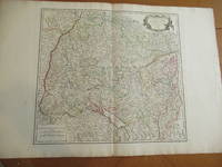
Cercle De Souabe [Original Antique Map from the Atlas Universal of 1757, with Lake Constance, Stuttgart, Augsburg, Etc.]
by Vaugondy, Robert
- Used
- near fine
- Condition
- Used - Near Fine
- Edition
- Original Antique Map
- Binding
- Unknown
- Quantity Available
- 1
- Seller
-
Pasadena, California, United States
- Item Price
-
$360.00
Show Details
Description:
Paris: Robert Vaugondy, 1751. Original Antique Map . Single Sheet. Near Fine. 22" x 32. Original very large antique map, extracted from an atlas. Very detailed, with hundreds of towns and villages, probably all in existence at the time, and showing jurisdictional boundaries as well.
Item Price
$360.00
![Americae Sive Novi Orbis, Nova Descriptio [Reprinted Engraved Antique Map]](https://d3525k1ryd2155.cloudfront.net/h/585/523/637523585.0.m.jpg)
Americae Sive Novi Orbis, Nova Descriptio [Reprinted Engraved Antique Map]
by Ortelius, Abraham
- Used
- near fine
- Condition
- Used - Near Fine
- Jacket Condition
- No Jacket
- Edition
- 5th or later Edition
- Binding
- Unknown
- Quantity Available
- 1
- Seller
-
Pasadena, California, United States
- Item Price
-
$270.00
Show Details
Description:
(: Abraham Ortelius (Original 1587 But This A Reprint), 1587. 5th or later Edition . No Binding. Near Fine/No Jacket. 19" x 17. Image Size: 18 7/8" X 13 3/4". Text "Cum Privilegio Decennali Ab. Ortelius Delineab. Et Excudeb. 1587" At Lower Right. However, This Must Be A Late Eighteenth Century To Twentieth Century Reprint, Printed On Wove Paper, Sheet Never Placed In An Atlas. Strong Impression And Color, Minor Loss Of A Millimeter Depth In A Tiny Area Of Lower Left Margin, Otherwise Undamaged. Margins Irregular, Up To 1" Deep. Professionally Cleaned And De-Acidified With Archival Materials By A Museum-Experienced Conservator.
Item Price
$270.00
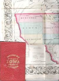
COLTON'S TOWNSHIP MAP OF THE STATE OF IOWA: Compiled from the United Statees Surveys & other Authentic Sources.; Drawn by George W. Colton. Engraved by J.M. Atwood
by Iowa
- Used
- good
- Condition
- Used - Good
- Edition
- 1855 edition
- Binding
- Unknown
- Quantity Available
- 1
- Seller
-
Roosevelt, New Jersey, United States
- Item Price
-
$300.00
Show Details
Description:
New York: J.H. Colton & Co, 1855. 1855 edition. Original Cloth. Good. Full-color engraved map, colored by hand, scrollwork border on all sides, opens to 25" x 29"; repairable separations at the intersections of several folds. Folds into red cloth case with embossed all-over design on both covers, gilt lettering on front. 5.5" x 3.75" [OCLC locates three holdings of this edition: Grinnell Col, U Iowa, Stanford U. Decker 23:225--1870 edition.].
Item Price
$300.00

More Photos
Viaggio a Pompei a Pesto e di ritorno ad Ercolano en a Pozzuoli
by ROMANELLI, Domenico
- Used
- very good
- Paperback
- Condition
- Used - Very Good
- Binding
- Paperback
- Quantity Available
- 1
- Seller
-
Cuernavaca, Morelos, Mexico
- Item Price
-
$440.00
Show Details
Description:
Napoli, Angelo Trani, 1817En 8vo. 2 Vol. V.I: 288pp, 2 folding fmaps of Pompei and Fondona Pianta.; V. II: 276pp + engraving and one folding map. Original publishers paperback in an elegant full calf box. Hand made paper, uncut. Vol I with old worm marks in several pages (minor text damage).The edition was updated with all of the new disvoveries, a very precise map of Pompey and of the voyage to Pozzuol.Romanelli, Domenico (1756-1819) Abbé. – was an Italian historian and archaeologist. Curator of the Public Library in Napoli.Nice set.
Item Price
$440.00
Amerique Septrionale [ Original Map From The Atlas Universal Illustre, By Levasseur, V. / Laguillermie]
by Levasseur, V. / Laguillermie
- Used
- Condition
- Used - Very Good +
- Edition
- Original Antique Map
- Binding
- Unknown
- Quantity Available
- 1
- Seller
-
Pasadena, California, United States
- Item Price
-
$135.00
Show Details
Description:
Paris Circa 1840: A. Combette, 1840. Original Antique Map . Single Sheet. Very Good +. 21" x 14 1/4. Large Color Views By Raimond Bonheur. Original Decorative Map 21" X 14 1/4" Of North America Showing The United States As Claiming Much Of British Colombia, With The West Coast Of The Usa Continuing Well Into Present-Day Canada; Texas As A Republic; Guatemala Encompassing All Of Central America South Of Chiapas And Belize And North Of Panama. Large Panels At Sides With Detailed, Attractive And Well Colored Views Of People, Wildlife, Vegetation, High Mountains, Etc.Colors Very Bright And Well-Placed.
Item Price
$135.00
Cercle De Souabe [Original Antique Map from the Atlas Universal of 1757, with Lake Constance, Stuttgart, Augsburg, Etc.]
by Vaugondy, Robert
- Used
- near fine
- Condition
- Used - Near Fine
- Edition
- Original Antique Map
- Binding
- Unknown
- Quantity Available
- 1
- Seller
-
Pasadena, California, United States
- Item Price
-
$360.00
Show Details
Description:
Paris: Robert Vaugondy, 1751. Original Antique Map . Single Sheet. Near Fine. 22" x 32. Original very large antique map, extracted from an atlas. Very detailed, with hundreds of towns and villages, probably all in existence at the time, and showing jurisdictional boundaries as well.
Item Price
$360.00
Americae Sive Novi Orbis, Nova Descriptio [Reprinted Engraved Antique Map]
by Ortelius, Abraham
- Used
- near fine
- Condition
- Used - Near Fine
- Jacket Condition
- No Jacket
- Edition
- 5th or later Edition
- Binding
- Unknown
- Quantity Available
- 1
- Seller
-
Pasadena, California, United States
- Item Price
-
$270.00
Show Details
Description:
(: Abraham Ortelius (Original 1587 But This A Reprint), 1587. 5th or later Edition . No Binding. Near Fine/No Jacket. 19" x 17. Image Size: 18 7/8" X 13 3/4". Text "Cum Privilegio Decennali Ab. Ortelius Delineab. Et Excudeb. 1587" At Lower Right. However, This Must Be A Late Eighteenth Century To Twentieth Century Reprint, Printed On Wove Paper, Sheet Never Placed In An Atlas. Strong Impression And Color, Minor Loss Of A Millimeter Depth In A Tiny Area Of Lower Left Margin, Otherwise Undamaged. Margins Irregular, Up To 1" Deep. Professionally Cleaned And De-Acidified With Archival Materials By A Museum-Experienced Conservator.
Item Price
$270.00

Atlas De Diego Homen 1561 ( Limited Numbered Leatherbound Edition With Slipcase )
by Diego Homen
- Used
- very good
- Hardcover
- Condition
- Used - Very Good
- Binding
- Hardcover
- ISBN 10 / ISBN 13
- 9788440093936 / 8440093934
- Quantity Available
- 1
- Seller
-
krotz springs, Louisiana, United States
- Item Price
-
$350.00
Show Details
Description:
1975. Hardcover. Very Good. Limited Numbered Edition #834 Of 1500 Copies Bound In Full Leather With Slipcase...Color Two Page Facsimile Prints.. Nice Clean Copy..Beautiful Copy..Spanish Language Text
Item Price
$350.00
More Photos
Viaggio a Pompei a Pesto e di ritorno ad Ercolano en a Pozzuoli
by ROMANELLI, Domenico
- Used
- very good
- Paperback
- Condition
- Used - Very Good
- Binding
- Paperback
- Quantity Available
- 1
- Seller
-
Cuernavaca, Morelos, Mexico
- Item Price
-
$440.00
Show Details
Description:
Napoli, Angelo Trani, 1817En 8vo. 2 Vol. V.I: 288pp, 2 folding fmaps of Pompei and Fondona Pianta.; V. II: 276pp + engraving and one folding map. Original publishers paperback in an elegant full calf box. Hand made paper, uncut. Vol I with old worm marks in several pages (minor text damage).The edition was updated with all of the new disvoveries, a very precise map of Pompey and of the voyage to Pozzuol.Romanelli, Domenico (1756-1819) Abbé. – was an Italian historian and archaeologist. Curator of the Public Library in Napoli.Nice set.
Item Price
$440.00

Stock Photo: Cover May Be Different
A Journal of the Plague Year: Being Observations or Memorials of the Most Remarkable Occurrences, As Well (Penguin Classics)
by Daniel Defoe; Editor-Anthony Burgess; Editor-Christopher Bristow
- Used
- good
- Paperback
- Condition
- Used - Good
- Binding
- Paperback
- ISBN 10 / ISBN 13
- 9780140430158 / 0140430156
- Quantity Available
- 1
- Seller
-
HOUSTON, Texas, United States
- Item Price
-
$6.23
Show Details
Description:
Penguin Classics, 1966-11-30. Paperback. Good.
Item Price
$6.23

A Visitation of the Plague (Classic, 60s)
by Daniel Defoe; Editor-Anthony Burgess; Editor-Christopher Bristow
- Used
- good
- Paperback
- Condition
- Used - Good
- Binding
- Paperback
- ISBN 10 / ISBN 13
- 9780146001598 / 0146001591
- Quantity Available
- 1
- Seller
-
HOUSTON, Texas, United States
- Item Price
-
$7.49
Show Details
Description:
Penguin (Non-Classics), 1996-08-01. Paperback. Good.
Item Price
$7.49

Small Business Management Fundamentals
by John F. Burgess; Daniel Steinhoff
- Used
- good
- Paperback
- Condition
- Used - Good
- Binding
- Paperback
- ISBN 10 / ISBN 13
- 9780070611504 / 0070611505
- Quantity Available
- 3
- Seller
-
Seattle, Washington, United States
- Item Price
-
$8.57
Show Details
Description:
McGraw-Hill Companies, The, 1988. Paperback. Good. Pages can have notes/highlighting. Spine may show signs of wear. ~ ThriftBooks: Read More, Spend Less.Dust jacket quality is not guaranteed.
Item Price
$8.57
Private Pictures
by Angeli, Daniel; Dousset, Jean-paul & Burgess, Anthoony
- Used
- good
- Paperback
- first
- Condition
- Used - Good
- Edition
- 1st
- Binding
- Paperback
- Quantity Available
- 1
- Seller
-
Barstow, California, United States
- Item Price
-
$4.00
Show Details
Description:
Bedford Square, London: Jonathan Cape. A good used copy. Previous owner's bookplate inside on half-title pages. Alos black marker has been used to fill in an edge that was showing white through the black coloring and it can be noticed fairly easily. Outstanding b/w private photos of celebrities. Size: 4to - over 9¾" - 12" Tall . Good. Paperback. 1st. 1980.
Item Price
$4.00

Stock Photo: Cover May Be Different
Private Pictures: Photographs
by Angeli, Daniel, and Dosset, Jean-Paul (photographs); Anthony Burgess (intro.)
- Used
- near fine
- Paperback
- first
- Condition
- Used - Near Fine
- Edition
- First Edition
- Binding
- Paperback
- ISBN 10 / ISBN 13
- 9780670578498 / 0670578495
- Quantity Available
- 1
- Seller
-
Kutztown, Pennsylvania, United States
- Item Price
-
$5.00
Show Details
Description:
New York: Viking Press, 1980. Book. Near Fine. Soft cover. First Edition. 4to - over 9¾" - 12" tall. Black stiff wraps, lettered in silver. Minor shelf wear. Unpaginated, approx. [96] pp., illus. w/ b&w plates. First-generation paparazzi..
Item Price
$5.00

Directions for Daily Holy Living
by Burgess, Daniel
- New
- Paperback
- Condition
- New
- Binding
- Paperback
- ISBN 10 / ISBN 13
- 9781626632141 / 1626632146
- Quantity Available
- 1
- Seller
-
Blairsville, Georgia, United States
- Item Price
-
$10.95
Show Details
Description:
New.
Item Price
$10.95

Stock Photo: Cover May Be Different
Mortimer Loses a Friend: Third Editon, Russian Translation: A Dual Language Book (Mortimer Adventures) (Russian Edition)
by Deregnier, Diana; Burgess, Daniel [Illustrator]; Parfenyuk, Tanya [Translator];
- Used
- Paperback
- Condition
- Used:Good
- Binding
- Paperback
- ISBN 10 / ISBN 13
- 9781499325188 / 1499325185
- Quantity Available
- 1
- Seller
-
HOUSTON, Texas, United States
- Item Price
-
$16.25
Show Details
Description:
CreateSpace Independent Publishing Platform, 2014-12-31. Paperback. Used:Good.
Item Price
$16.25
Stock Photo: Cover May Be Different
Mortimer Loses a Friend: Third Editon, Russian Translation: A Dual Language Book (Mortimer Adventures) (Russian Edition)
by Deregnier, Diana; Burgess, Daniel [Illustrator]; Parfenyuk, Tanya [Translator];
- Used
- Paperback
- Condition
- Used: Good
- Binding
- Paperback
- ISBN 10 / ISBN 13
- 9781499325188 / 1499325185
- Quantity Available
- 1
- Seller
-
HOUSTON, Texas, United States
- Item Price
-
$16.90
Show Details
Description:
CreateSpace Independent Publishing Platform, 2014-12-31. Paperback. Used: Good.
Item Price
$16.90

Stock Photo: Cover May Be Different
The Key to Time - Tempus Fugit
by Seidler, R.M.; Burgess, Daniel [Illustrator]
- Used
- Paperback
- Condition
- Used: Good
- Binding
- Paperback
- ISBN 10 / ISBN 13
- 9780998362427 / 0998362425
- Quantity Available
- 1
- Seller
-
HOUSTON, Texas, United States
- Item Price
-
$18.85
Show Details
Description:
Raven House Media, 2020-02-20. Paperback. Used: Good.
Item Price
$18.85
Stock Photo: Cover May Be Different
The Key to Time - Tempus Fugit
by Seidler, R.M.; Burgess, Daniel [Illustrator]
- Used
- Paperback
- Condition
- Used:Good
- Binding
- Paperback
- ISBN 10 / ISBN 13
- 9780998362427 / 0998362425
- Quantity Available
- 1
- Seller
-
HOUSTON, Texas, United States
- Item Price
-
$18.85
Show Details
Description:
Raven House Media, 2020-02-20. Paperback. Used:Good.
Item Price
$18.85

More Photos
The Sky and the Forest
by Forester, C.S
- Used
- very good
- Hardcover
- first
- Condition
- Used - Very Good
- Jacket Condition
- Very Good
- Edition
- First Edition
- Binding
- Hardcover
- Quantity Available
- 1
- Seller
-
Salem, Oregon, United States
- Item Price
-
$34.89$17.45Save $17.44!
Show Details
Description:
C.S. Forester: The Sky and the Forest. Little, Brown and Company, Boston. Stated First Edition First Printing Thus August, 1948. Cover price $2.75. Used. VG BOOK/VG UNCLIPPED DUST JACKET. A story of a central Africa. By C.S. Forester, author of the Admiral Hornblower series.
Item Price
$34.89$17.45
Save $17.44
!

More Photos
Plat Book: Pierce County, Wisconsin
by Rhame, A. E
- Used
- Fine
- Paperback
- Condition
- Used - Fine
- Binding
- Paperback
- Quantity Available
- 1
- Seller
-
Woodruff, Wisconsin, United States
- Item Price
-
$46.66
Show Details
Description:
1930. Soft Cover. Fine. Unpaginated. Tan colored book is in Fine condition, no sign of wear.
Item Price
$46.66
![Alaska and Klondike Region; [With inset of Klondike Region on the Upper Yukon detail] [From an...](https://d3525k1ryd2155.cloudfront.net/h/062/537/1339537062.0.m.jpg)
Alaska and Klondike Region; [With inset of Klondike Region on the Upper Yukon detail] [From an atlas, "Gazetteer of Alaska and Yukon Region " pp. 105 and 106]
by Miller, J. Martin
- Used
- very good
- Condition
- Used - Very Good
- Edition
- Unknown
- Quantity Available
- 1
- Seller
-
Sebastopol, California, United States
- Item Price
-
$39.00
Show Details
Description:
Chicago: J. Martin Miller, 1899. Unknown. Map. Very Good. [Map copyright 1899, printing date of Atlas later] [19.875x15.125in]; Colored map of Alaska with steamer routes from Portland and Seattle, insets of the Klondike Region on the Upper Yukon and Western portion of Aleutian Islands; On verso index of places and names with two large black and white images; Age toning to all edges, water stain marks on bottom, slight printing offset of colors, small chips and closed tears to lower edge;.
Item Price
$39.00

Zemepis Sveta - Monsunova Asie
by De La Blache, P. Vidal; Gallois, L
- Used
- Hardcover
- Condition
- Used - Very Good Condition
- Jacket Condition
- No Dust Jacket
- Binding
- Hardcover
- Quantity Available
- 1
- Seller
-
Oak Point, Texas, United States
- Item Price
-
$60.00
Show Details
Description:
Aventinum, Prague, Czechoslovakia, 1930. Hardcover. Very Good Condition/No Dust Jacket. Text entirely in Czech. Geography book on Asia with numerous photographs and maps. 1931 edition also available. Size: 4mo - over 9 3/4" - 12" tall. 400 pp. Pages are yellowed, but are tight and clean. Moderate shelfwear along the spine. Corners are lightly bumped. Quantity Available: 1. Shipped Weight: 3-5 pounds. Category: Travel & Places; Non-English Language::Czech; Pictures of this item not already displayed here available upon request. Inventory No: 001227. . Additional shipping charges may apply.
Item Price
$60.00

Zemepis Sveta - Monsunova Asie
by De La Blache, P. Vidal; Gallois, L
- Used
- Hardcover
- Condition
- Used - Very Good Condition
- Jacket Condition
- No Dust Jacket
- Binding
- Hardcover
- Quantity Available
- 1
- Seller
-
Oak Point, Texas, United States
- Item Price
-
$60.00
Show Details
Description:
Aventinum, Prague, Czechoslovakia, 1931. Hardcover. Very Good Condition/No Dust Jacket. Text entirely in Czech. Geography book on Asia with numerous photographs and maps. 1930 edition also available. Size: 4mo - over 9 3/4" - 12" tall. 400 pp. Pages are yellowed, but are tight and clean. Moderate shelfwear along the spine. Corners are lightly bumped. Quantity Available: 1. Shipped Weight: 3-5 pounds. Category: Travel & Places; Non-English Language::Czech; Pictures of this item not already displayed here available upon request. Inventory No: 001228. . Additional shipping charges may apply.
Item Price
$60.00

Last Tales
by Dinesen, Isak
- Used
- very good
- Hardcover
- first
- Condition
- Used - Very Good
- Jacket Condition
- Good+
- Edition
- First Edition
- Binding
- Hardcover
- Quantity Available
- 1
- Seller
-
Salem, Oregon, United States
- Item Price
-
$120.00$60.00Save $60.00!
Show Details
Description:
Dinesen, Isak: Last Tales, A Collection of Twelve New Tales of Compelling Beauty 1957, Random House. First Edition. Stated First Printing Thus. Used. Very Good/Good+ original red dust jacket, price-clipped. Jacket states 11/57 on front flap. 5 3/4 X
Item Price
$120.00$60.00
Save $60.00
!

The Adventure of Wrangel Island
by Vilhjalmur Stefansson
- Used
- good
- Hardcover
- first
- Condition
- Used - Good
- Jacket Condition
- No DJ Included
- Edition
- First Edition
- Binding
- Hardcover
- Quantity Available
- 1
- Seller
-
Salem, Oregon, United States
- Item Price
-
$124.89$62.45Save $62.44!
Show Details
Description:
The Adventure of Wrangel Island, Alaska (1925 Macmillan 1st Edition) HISTORY OF ALASKA. EXLIB. Good Condition/ No DJ included. Fold-out map affixed to binding at the back of the book has never been opened. The story of the (unsuccessful) attempted colonization of Wrangel Island Alaska. 413 pages plus appendix, Index. Titling is still bright. A clean, solid copy. Scarce.
Item Price
$124.89$62.45
Save $62.44
!

Seven Pillars Of Wisdom, A Triumph
by Lawrence, T.E
- Used
- good
- Hardcover
- first
- Condition
- Used - Good
- Jacket Condition
- No DJ Included
- Edition
- First American Edition
- Binding
- Hardcover
- Quantity Available
- 1
- Seller
-
Salem, Oregon, United States
- Item Price
-
$124.95$62.48Save $62.47!
Show Details
Description:
T.E. Lawrence. SEVEN PILLARS OF WISDOM, A TRIUMPH. AUTOBIOGRAPHY. Privately Printed, 1926. First Published for general circulation 1935. First American Edition. States MCMXXXVI on the title page. Doubleday, Doran & Company, Inc. Garden City, NY. GOOD CONDITION/ NO DUST JACKET IS INCLUDED. 672 pages, indexed. Beige buckram boards. Spine has darkened a bit. 6 7/8 X 9 ½.
Item Price
$124.95$62.48
Save $62.47
!

Asia from the Best Authorities, Russell, ca.1800
by Russell
- Used
- Condition
- Used
- Quantity Available
- 1
- Seller
-
Plymouth, Devon, United Kingdom
- Item Price
-
$25.37
Show Details
Description:
Russell, J. : Asia from the Best Authorities. Nd but ca.1800. From "A New Geographical, Historical and Commercial Grammar and Present State of Several Kingdoms of the World". Copper engraving. Size approx 200 x 230mm. Two neat folds. Some age colouring to edges, otherwise clean and bright. Includes Arabia, India, Borneo, Japan, China and eastern Russia.
Item Price
$25.37

North America from the Best Authorities, Russell, ca.1800
by Russell
- Used
- Condition
- Used
- Quantity Available
- 1
- Seller
-
Plymouth, Devon, United Kingdom
- Item Price
-
$25.37
Show Details
Description:
Russell, J. : A General Map of North America from the Best Authorities. Nd but ca.1800. From "A New Geographical, Historical and Commercial Grammar and Present State of Several Kingdoms of the World." Copper engraving. Size approx 200 x 230mm. Two neat folds. Some age colouring to edges, otherwise very clean and bright.
Item Price
$25.37