Description:
Paris: Ganeau, 1744. Excellent condition, strong impression, b&w engraved copperplate from Tome III of the 4to, 1744 edition of Charlevoix's "Histoire de la Nouvelle France" (Journal D'un Voyage...). The image is 9.5 x 14.5 inches, with folds as issued. This image has the full eastern USA, including Louisiane, north to Newfoundland, most of the Great Lakes, teh Atlantic Ocean, Acores, and east to the western coasts of Africa, Spain, France and British Isles. It is quite attractive, and not often seen for sale in this early state..
Standard Classic Atlas For Schools And Colleges With An Alphabetical Index Giving The Latitudes And Longitudes Of Nearly 10,000 Places -
Standard Classic Atlas for Schools and Colleges with an Alphabetical Index Giving the Latitudes and Longitudes of Nearly 10,000 Places
- Used
- near fine
- Hardcover
- first
New York and Chicago: Ivison, Blakeman, Taylor & Company, 1885. RARE, Worldcat lists only one institutional holding . Contains 22 two-page maps of ancient countries and empires plus 30 pp. Index with latitudes and longitudes of nearly 10,000 places. Near Fine, small number in ink top corner front paste down, light rubbing to cloth at tips. Maps include Orbis Veteribus Notus, Romanum Imperium, Hispania, Gallia, Asia Minor, Syria, Aegyptus, Africa et Libya, etc. . First Edition. Cloth. Near Fine/No Jacket, As Issued. 8vo - over 7¾" - 9¾" tall.
-
Bookseller
Independent bookstores
 (US)
(US)
- Format/Binding Hardcover
- Book Condition Used - Near Fine
- Jacket Condition No Jacket, As Issued
- Edition First Edition
- Binding Hardcover
- Publisher Ivison, Blakeman, Taylor & Company
- Place of Publication New York and Chicago
- Date Published 1885
- Size 8vo - over 7¾" - 9&f
- Size 8vo - over 7¾" - 9¾" tall

(Map of Eastern America and Atlantic Ocean): Carte De L'Ocean Occidental et Partie De L'Amerique Septentrionale..Charlevoix..fait En 1720
by Bellin, Jacques Nicolas
- Used
- Condition
- Used
- Binding
- Unknown
- Quantity Available
- 1
- Seller
-
Crozet, Virginia, United States
- Item Price
-
$485.00
Show Details
Item Price
$485.00

More Photos
Handy Map & Guide to London with index to Streets (Cruchley's Handy Map of London)
by No Author
- Used
- very good
- Paperback
- Condition
- Used - Very good
- Binding
- Paperback
- Quantity Available
- 1
- Seller
-
Southampton, Hampshire, United Kingdom
- Item Price
-
$285.08
Show Details
Description:
Gall & Inglis', 1870's-1880's. Paperback. Very good. VGC.Gall & Inglis'.No date given but probably 1870's to 1880's prior to London Tower Bridge build, which is not included on the map.Green hardback(small dents,nicks and light shelf wear on the cover) with folded map in VGC.The map is in VGC but with small stain marks and foxing marks on the edges,small tear on the edge of the map.The map is hand coloured and includes:Railways,Railway Stations,Steamer Routes,Omnibus and Tramway Routes,Parks.The size of the map is: 30x20 inch.The scale of the map is: 3 3/4 to 1 mile.The map covers: From Hyde Park(including parts of Kensington Palace) to Blackwall and from Mildmay Park to South Lambeth.The map is in VGC for its age. A collectable and scarce map.
Item Price
$285.08
More Photos
New England, New York, New Jersey, and Pensilvania &c. by H. Moll Geographer
by Moll, Herman
- Used
- near fine
- Condition
- Used - Near Fine
- Binding
- Unknown
- Quantity Available
- 1
- Seller
-
Lansdowne, Pennsylvania, United States
- Item Price
-
$464.00
Show Details
Description:
London: H. Moll, 1708. Near Fine. 1 sheet 232 x 267 mm. (image is 180 x 254 mm.) Hand-colored copper engraved map. This is Herman Moll's earliest map of New England, published in the first edition of John Oldmixon's The British Empire in North America in 1708. List of 19 towns in lower right-hand corner. New Jersey is shown as East New Jersey and West New Jersey. Pennsylvania still contains the Lower Counties, which separated and became Delaware in 1704. On the west side of the Susquehanna River is shown "The Present Sasquahana Indian Fort." In Near Fine Condition: light creasing; clean and bright.
Item Price
$464.00

More Photos
Viaggio a Pompei a Pesto e di ritorno ad Ercolano en a Pozzuoli
by ROMANELLI, Domenico
- Used
- very good
- Paperback
- Condition
- Used - Very Good
- Binding
- Paperback
- Quantity Available
- 1
- Seller
-
Cuernavaca, Mexico
- Item Price
-
$440.00
Show Details
Description:
Napoli, Angelo Trani, 1817En 8vo. 2 Vol. V.I: 288pp, 2 folding fmaps of Pompei and Fondona Pianta.; V. II: 276pp + engraving and one folding map. Original publishers paperback in an elegant full calf box. Hand made paper, uncut. Vol I with old worm marks in several pages (minor text damage).The edition was updated with all of the new disvoveries, a very precise map of Pompey and of the voyage to Pozzuol.Romanelli, Domenico (1756-1819) Abbé. – was an Italian historian and archaeologist. Curator of the Public Library in Napoli.Nice set.
Item Price
$440.00

More Photos
1875 ILLINOIS CENTRAL MAP.: Map of the Illinois Central Railroad and its Connections.
- Used
- Condition
- Used
- Quantity Available
- 1
- Seller
-
Houston, Texas, United States
- Item Price
-
$295.00
Show Details
Description:
[Railroad] Map of the Illinois Central Railroad and its Connections. Chicago: Rand McNally and Company Map Engravers. 1875. Map printed on green paper. 33 x 25 on sheet 40 x 38 cm folded to 9 x 19 cm. Added text printed in green in margins around map. One three inch fold split, else very good.OCLC shows one holding (Newberry Lib.) Relief shown by hachures. Timetables on verso "corrected to June 20th, 1875." Text describing routes and connections on 5 panels on verso: Illinois Central Railroad principal connections -- Illinois Central Railroad Dubuque and Sioux City Line! -- Illinois Central Railroad, the direct route from Chicago to Springfield, Farmer City, Clinton and Mt. Pulaski -- Illinois Central Railroad St. Louis through line -- Illinois Central Railroad New Orleans through line.
Item Price
$295.00

(Map of Pennsylvania): Geographical, Statistical, and Historical Map of Pennsylvania
by Carey & Lea (engr.by Young & Delleker)
- Used
- Hardcover
- first
- Condition
- Used
- Binding
- Hardcover
- Quantity Available
- 1
- Seller
-
Crozet, Virginia, United States
- Item Price
-
$400.00
Show Details
Description:
Philadelphia (Chestnut Street), 1822: HC Carey and I Lea, 1822. VG due to some minimal dampstaining most evident left upper corner, and minimally crossing neatline. The color portion of the map shows no significant visual effects from the stains. The original hand-colored image is clear and bright, with the surrounding letterpre ss text detailing aspects of population, climate, commerce, religion, government. There is a nice general historical sketch (in a separate page of original text, included here-- "Appendix to No. 18") in the letterpress. From the first edition "A Complete Historical, Chronological, and Geographical American Atlas...", which was also the first American atlas with letterpress printing on the map. This is a nice map, but for the defects described. The map image is 45x31cm; the entire image is 52.5x42cm..
Item Price
$400.00

More Photos
Plan of the Battle of Waterloo
by Edward Cotton
- Used
- good
- Hardcover
- Condition
- Used - Good
- Binding
- Hardcover
- Quantity Available
- 1
- Seller
-
Boonsboro, Maryland, United States
- Item Price
-
$318.50
Show Details
Description:
1854. Hardcover. Good. Lithograph map with original hand-colored highlights. Approximately 12 1/4 X 12 1/2" on 18 X 18" sheet with extensive printed text at all margins. Title and credit in the map at upper right, good condition with some aging at folds. <br> Original slim 12mo dark green leather-covered board folder with gilt lettering at upper cover. Some scuffing and wear at edges. Additional smaller lithograph map with hand-colored highlights mounted at inside of upper cover. Lengthy 1858 pencil notation of purchase ("on the Field of Waterloo") from Cotton's niece on verso of map.
Item Price
$318.50

More Photos
SMITH'S NEW MAP OF PHILADELPHIA AND VICINITY
by Smith, J. L.
- Used
- Hardcover
- Condition
- Used - Very Good+
- Binding
- Hardcover
- Quantity Available
- 1
- Seller
-
Fairfield, New Jersey, United States
- Item Price
-
$280.00
Show Details
Description:
Philadelphia: J. L. Smith. Very Good+. 1898. Hardcover. One large map Issued in two separate sheets; each 23" x 27 1/2". The folding maps are backed on linen. The maps are mounted in a green cloth hardcover folder with bright glit title on front. Pennsylvania; Thin 12mo 7" - 7½" tall .
Item Price
$280.00
![Early New York [cover title]. [Five Maps of New York]](https://d3525k1ryd2155.cloudfront.net/h/139/400/1315400139.0.m.jpg)
Early New York [cover title]. [Five Maps of New York]
by MacCOUN, Townsend
- Used
- first
- Condition
- Used - A fragile set with the maps printed on delicate, thin paper that, despite the condition issues outlined separately, has remained
- Binding
- Unknown
- Quantity Available
- 1
- Seller
-
Ardsley, New York, United States
- Item Price
-
$450.00
Show Details
Description:
New York: Townsend MacCoun, 1909. A fragile set with the maps printed on delicate, thin paper that, despite the condition issues outlined separately, has remained fresh and bright, with strong coloring and a lack of offsetting; the portfolio a bit faded and soiled and with some light wear at the extremities. Portfolio containing five loose folding color maps printed by L. L. Poates Engineering Co., NY: 1. 1609. The Island of Manhattan (Mannahtin) at the Time of Its Discovery. 410 x 132 cm. Based on the early colonial surveys of Ratzer, Montresor, Knypthausen, Bradford, Duyckinck and the 1867 survey by E. L. Viele. (A few small holes and separations along folds.) - 2. 1609 The Hudson River (Cahohatatea) at the Time of Its Discovery by Henry Hudson. 22 x 85 cm. (Upper and lower sections separated along folds.) - 3. 1653-1664 Amsterdam in New Netherland. The City of the Dutch West India Company. 61 x 43 cm. (A few small separations along folds). - 4. 1730 New York. The English Colonial City. 60.5 x…
Read More Item Price
$450.00
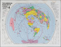
The Amateur Radio Relay League: Amateur Radio Map of the World
by American Radio Relay League
- Used
- Condition
- Used
- Quantity Available
- 1
- Seller
-
FRAMINGHAM, Massachusetts, United States
- Item Price
-
$325.00
Show Details
Description:
Color print on glossy paperDimensions: 31" x 40 3/4"Condition: as found, water stain along top margin, bright colors throughoutThis American Radio Relay League divides the world into radio relay league zones rather than political or geographic boundaries. The map could be thought of as a ham radio listeners "bird's ear" view of the world. Each zone is identified by the call letters for that zone, immediately recognizable to the experienced ham radio operator and part of a language unique to this kind of radio communication.
Item Price
$325.00

More Photos
The Sky and the Forest
by Forester, C.S
- Used
- very good
- Hardcover
- first
- Condition
- Used - Very Good
- Jacket Condition
- Very Good
- Edition
- First Edition
- Binding
- Hardcover
- Quantity Available
- 1
- Seller
-
Salem, Oregon, United States
- Item Price
-
$34.89$20.93Save $13.96!
Show Details
Description:
C.S. Forester: The Sky and the Forest. Little, Brown and Company, Boston. Stated First Edition First Printing Thus August, 1948. Cover price $2.75. Used. VG BOOK/VG UNCLIPPED DUST JACKET. A story of a central Africa. By C.S. Forester, author of the Admiral Hornblower series.
Item Price
$34.89$20.93
Save $13.96
!
![Alaska and Klondike Region; [With inset of Klondike Region on the Upper Yukon detail] [From an...](https://d3525k1ryd2155.cloudfront.net/h/062/537/1339537062.0.m.jpg)
Alaska and Klondike Region; [With inset of Klondike Region on the Upper Yukon detail] [From an atlas, "Gazetteer of Alaska and Yukon Region " pp. 105 and 106]
by Miller, J. Martin
- Used
- very good
- Condition
- Used - Very Good
- Edition
- Unknown
- Quantity Available
- 1
- Seller
-
Sebastopol, California, United States
- Item Price
-
$39.00
Show Details
Description:
Chicago: J. Martin Miller, 1899. Unknown. Map. Very Good. [Map copyright 1899, printing date of Atlas later] [19.875x15.125in]; Colored map of Alaska with steamer routes from Portland and Seattle, insets of the Klondike Region on the Upper Yukon and Western portion of Aleutian Islands; On verso index of places and names with two large black and white images; Age toning to all edges, water stain marks on bottom, slight printing offset of colors, small chips and closed tears to lower edge;.
Item Price
$39.00

Zemepis Sveta - Monsunova Asie
by De La Blache, P. Vidal; Gallois, L
- Used
- Hardcover
- Condition
- Used - Very Good Condition
- Jacket Condition
- No Dust Jacket
- Binding
- Hardcover
- Quantity Available
- 1
- Seller
-
Oak Point, Texas, United States
- Item Price
-
$60.00
Show Details
Description:
Aventinum, Prague, Czechoslovakia, 1931. Hardcover. Very Good Condition/No Dust Jacket. Text entirely in Czech. Geography book on Asia with numerous photographs and maps. 1930 edition also available. Size: 4mo - over 9 3/4" - 12" tall. 400 pp. Pages are yellowed, but are tight and clean. Moderate shelfwear along the spine. Corners are lightly bumped. Quantity Available: 1. Shipped Weight: 3-5 pounds. Category: Travel & Places; Non-English Language::Czech; Pictures of this item not already displayed here available upon request. Inventory No: 001228. . Additional shipping charges may apply.
Item Price
$60.00

Zemepis Sveta - Monsunova Asie
by De La Blache, P. Vidal; Gallois, L
- Used
- Hardcover
- Condition
- Used - Very Good Condition
- Jacket Condition
- No Dust Jacket
- Binding
- Hardcover
- Quantity Available
- 1
- Seller
-
Oak Point, Texas, United States
- Item Price
-
$60.00
Show Details
Description:
Aventinum, Prague, Czechoslovakia, 1930. Hardcover. Very Good Condition/No Dust Jacket. Text entirely in Czech. Geography book on Asia with numerous photographs and maps. 1931 edition also available. Size: 4mo - over 9 3/4" - 12" tall. 400 pp. Pages are yellowed, but are tight and clean. Moderate shelfwear along the spine. Corners are lightly bumped. Quantity Available: 1. Shipped Weight: 3-5 pounds. Category: Travel & Places; Non-English Language::Czech; Pictures of this item not already displayed here available upon request. Inventory No: 001227. . Additional shipping charges may apply.
Item Price
$60.00

North America from the Best Authorities, Russell, ca.1800
by Russell
- Used
- Condition
- Used
- Quantity Available
- 1
- Seller
-
Plymouth, Devon, United Kingdom
- Item Price
-
$25.34
Show Details
Description:
Russell, J. : A General Map of North America from the Best Authorities. Nd but ca.1800. From "A New Geographical, Historical and Commercial Grammar and Present State of Several Kingdoms of the World." Copper engraving. Size approx 200 x 230mm. Two neat folds. Some age colouring to edges, otherwise very clean and bright.
Item Price
$25.34

Asia from the Best Authorities, Russell, ca.1800
by Russell
- Used
- Condition
- Used
- Quantity Available
- 1
- Seller
-
Plymouth, Devon, United Kingdom
- Item Price
-
$25.34
Show Details
Description:
Russell, J. : Asia from the Best Authorities. Nd but ca.1800. From "A New Geographical, Historical and Commercial Grammar and Present State of Several Kingdoms of the World". Copper engraving. Size approx 200 x 230mm. Two neat folds. Some age colouring to edges, otherwise clean and bright. Includes Arabia, India, Borneo, Japan, China and eastern Russia.
Item Price
$25.34
![MAP OF UTAH [Territory]](https://d3525k1ryd2155.cloudfront.net/h/836/461/1485461836.0.m.jpg)
More Photos
MAP OF UTAH [Territory]
- Used
- Condition
- Used - Very Good-
- Edition
- Original
- Quantity Available
- 1
- Seller
-
Williamsburg, Virginia, United States
- Item Price
-
$65.00
Show Details
Description:
New York, Richmond, Chicago, & Toledo: H. H. Hardesty, 1885. Original color lithographed map printed by Rand, McNally & Company, Engravers and published in HARDESTY'S HISTORICAL AND GEOGRAPHICAL ENCYCLOPEDIA: SPECIAL VIRGINIA EDITION. 19 3/8 inches by 13 1/4 inches on a 21" X 14 1/2" sheet. The map depicts the Territory of Utah in its final form--large areas had been removed and ceded to Nevada, Colorado, Wyoming, and Nebraska since Utah became a U. S. Territory in 1850. The issue of polygamy prevented statehood until it was finally granted in 1896. This map features railroads and topography and uses color to set off counties from each other. Unlike most atlas maps of the period, this map identifies most small towns. The map is guaranteed to be moe than 135 years old. The map is in about very good condition: generally clean and bright, with slight toning of paper and one faint water stain near the center-left edge of the map.. Original. Single Sheet. Very Good-. Elephant…
Read More Item Price
$65.00

Philips Special Map of the Nile, The Advance on Khartum and the Environs of Omdurman. Cc1900
by George Philips and Son,
- Used
- Condition
- Used
- Quantity Available
- 1
- Seller
-
Plymouth, Devon, United Kingdom
- Item Price
-
$32.94
Show Details
Description:
Philips Special map of the Nile illustrating the Advance on Khartum [Khartoum] with an enlargement of the environs of Omdurman [Omdur]. George Philips and Son, London and Liverpool Ca 1900. 580mm x 900mm folded map. Front title wrapper has come loose, not affecting map area. Three maps are displayed within the sheet. Map1. Map of the Nile Valley 520mm x 300mm showing the approaches of Khartum. Scale 1inch to 100 Geographical miles. Coloured indicating Possessions and Protectorates of European Powers. Map 2. Special map of the Nile from Dongola to Khartum. Scale 16 miles to the inch. Coloured. In set in this map is Map3. Environs of Omdurman, Scale 5 statute miles to the inch. Some small breaks at some folds, not affecting imagery or use of map. Title label is damaged, the map is clean and bright, probably unused. A very interesting record.
Item Price
$32.94

Last Tales
by Dinesen, Isak
- Used
- very good
- Hardcover
- first
- Condition
- Used - Very Good
- Jacket Condition
- Good+
- Edition
- First Edition
- Binding
- Hardcover
- Quantity Available
- 1
- Seller
-
Salem, Oregon, United States
- Item Price
-
$120.00$72.00Save $48.00!
Show Details
Description:
Dinesen, Isak: Last Tales, A Collection of Twelve New Tales of Compelling Beauty 1957, Random House. First Edition. Stated First Printing Thus. Used. Very Good/Good+ original red dust jacket, price-clipped. Jacket states 11/57 on front flap. 5 3/4 X
Item Price
$120.00$72.00
Save $48.00
!

The Adventure of Wrangel Island
by Vilhjalmur Stefansson
- Used
- good
- Hardcover
- first
- Condition
- Used - Good
- Jacket Condition
- No DJ Included
- Edition
- First Edition
- Binding
- Hardcover
- Quantity Available
- 1
- Seller
-
Salem, Oregon, United States
- Item Price
-
$124.89$74.93Save $49.96!
Show Details
Description:
The Adventure of Wrangel Island, Alaska (1925 Macmillan 1st Edition) HISTORY OF ALASKA. EXLIB. Good Condition/ No DJ included. Fold-out map affixed to binding at the back of the book has never been opened. The story of the (unsuccessful) attempted colonization of Wrangel Island Alaska. 413 pages plus appendix, Index. Titling is still bright. A clean, solid copy. Scarce.
Item Price
$124.89$74.93
Save $49.96
!