Description:
Pitt, Moses and Swart, Stephaman. Duynckercke, [Dunkirk]. Ca 1683. Hand coloured, copper engraved sea-chart. Chart size 440 x 505 mm, sheet size 580mm x 690mm. Two charts on one sheet showing the Dunkirk approaches. The larger chart from that of Blaeu's Pourtraict de la fameuse ville et havre de Duynckercke. With Rhumb lines, compass rose and scales. Townships and sandbanks indicated. Decorated with fleets of galleons off shore. With an inset panorama of Duynckercke [Dunkirk] after Jan Van Loon and a smaller coastal profile of Cales. The smaller chart showing the coast of Flanders, from Walchren [ Walcheren ] to Boloigne. Early hand coloured charts with later red ruled border on wide blank margins. Small tear without loss to lower blank margin, otherwise in bright and clean condition. Rare and attractive Sea Charts.
Tabula Asiae III - 1548 map of area surrounding the Black Sea and the Caspian Sea by Gastaldi, Giacomo - 1548
by Gastaldi, Giacomo

Tabula Asiae III - 1548 map of area surrounding the Black Sea and the Caspian Sea
by Gastaldi, Giacomo
- Used
- near fine
Venice, 1548. No Binding. Near Fine/No Jacket. Single page woodcut map. 5" x 6 1/2". Hand tinted. Mounted on acid-free backing board with matte. Central vertical fold has been reinforced with archival tape applied to back surface. Depicts the land area between the Black Sea and the Caspian Sea. Two birds in lower right, a monkey and a camel in left margin, and a curiously house-like Noah's Ark floating in the Caspian. Removed (not by me!) from Gastaldi's "Geografia," a highly influential 16th century atlas. Please see photos for best description.
-
Bookseller
Alan Foljambe, Bookseller [ABAC/ILAB]
 (CA)
(CA)
- Format/Binding No Binding
- Book Condition Used - Near Fine
- Jacket Condition No Jacket
- Quantity Available 1
- Place of Publication Venice
- Date Published 1548
- Keywords MAP, ANTIQUE
- Product_type Map
![Sea Chart. Duynckercke [Dunkirk].](https://d3525k1ryd2155.cloudfront.net/h/721/019/192019721.0.m.jpg)
Sea Chart. Duynckercke [Dunkirk].: Original Antique Hand coloured, copper engraved sea-chart.
by Pitt, Moses and Swart, Stephaman
- Used
- very good
- first
- Condition
- Used - Very Good
- Quantity Available
- 1
- Seller
-
Plymouth, Devon, United Kingdom
- Item Price
-
$253.70
Show Details
Item Price
$253.70

More Photos
Portrait and Biographical Album of WILL COUNTY, ILLINOIS containing Full Page Portraits and Biographical Sketches of Prominent and Representative Citizens of the County 1890: 19th Century Geneology
by Chapman Brothers
- Used
- Hardcover
- first
- Condition
- Used - Good-
- Jacket Condition
- none
- Edition
- Later printing of the 1st edition, copyright 1885 Chapman
- Binding
- Hardcover
- Quantity Available
- 1
- Seller
-
Winfield, Illinois, United States
- Item Price
-
$250.00
Show Details
Description:
Book is in Very Good condition but the leather cover is fragile/Fair. All around gilt, spine is very worn and the hinges are cracked with the covers almost detached. 771 pages plus transportation. Also includes portraits and biographies of all the presidents of the U.S. and Governors of the State. A very large book, additional shipping outside the continental U.S.A.
Item Price
$250.00

Atlas De Diego Homen 1561 ( Limited Numbered Leatherbound Edition With Slipcase )
by Diego Homen
- Used
- very good
- Hardcover
- Condition
- Used - Very Good
- Binding
- Hardcover
- ISBN 10 / ISBN 13
- 9788440093936 / 8440093934
- Quantity Available
- 1
- Seller
-
krotz springs, Louisiana, United States
- Item Price
-
$350.00
Show Details
Description:
1975. Hardcover. Very Good. Limited Numbered Edition #834 Of 1500 Copies Bound In Full Leather With Slipcase...Color Two Page Facsimile Prints.. Nice Clean Copy..Beautiful Copy..Spanish Language Text
Item Price
$350.00
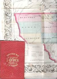
COLTON'S TOWNSHIP MAP OF THE STATE OF IOWA: Compiled from the United Statees Surveys & other Authentic Sources.; Drawn by George W. Colton. Engraved by J.M. Atwood
by Iowa
- Used
- good
- Condition
- Used - Good
- Edition
- 1855 edition
- Binding
- Unknown
- Quantity Available
- 1
- Seller
-
Roosevelt, New Jersey, United States
- Item Price
-
$300.00
Show Details
Description:
New York: J.H. Colton & Co, 1855. 1855 edition. Original Cloth. Good. Full-color engraved map, colored by hand, scrollwork border on all sides, opens to 25" x 29"; repairable separations at the intersections of several folds. Folds into red cloth case with embossed all-over design on both covers, gilt lettering on front. 5.5" x 3.75" [OCLC locates three holdings of this edition: Grinnell Col, U Iowa, Stanford U. Decker 23:225--1870 edition.].
Item Price
$300.00

More Photos
State of the Naton.
by Sollod, Ellen.
- Used
- Signed
- Condition
- Used
- Edition
- One-of-a-Kind
- Binding
- Unknown
- Quantity Available
- 1
- Seller
-
Hoover, Alabama, United States
- Item Price
-
$400.00
Show Details
Description:
Seattle, Washington:: Ellen Sollod,, 2020.. One-of-a-Kind. 12.5" x 9.5" x .75" closed,12.5" x 19" open. Altered book: "Hammond New Supreme World Atlas" published by Garden City Books, 1953. Signed and dated by the artist. Ellen Sollod: "All the states in the union featured in the atlas are torn and rearranged to call attention to the fractured state of the nation in 2019. Black and white photographs of particular sites, previously in the index, have been collaged into the body of the book. It is a call-to-action to knit our country together.
Item Price
$400.00

(Map of Pennsylvania): Geographical, Statistical, and Historical Map of Pennsylvania
by Carey & Lea (engr.by Young & Delleker)
- Used
- Hardcover
- first
- Condition
- Used
- Binding
- Hardcover
- Quantity Available
- 1
- Seller
-
Crozet, Virginia, United States
- Item Price
-
$400.00
Show Details
Description:
Philadelphia (Chestnut Street), 1822: HC Carey and I Lea, 1822. VG due to some minimal dampstaining most evident left upper corner, and minimally crossing neatline. The color portion of the map shows no significant visual effects from the stains. The original hand-colored image is clear and bright, with the surrounding letterpre ss text detailing aspects of population, climate, commerce, religion, government. There is a nice general historical sketch (in a separate page of original text, included here-- "Appendix to No. 18") in the letterpress. From the first edition "A Complete Historical, Chronological, and Geographical American Atlas...", which was also the first American atlas with letterpress printing on the map. This is a nice map, but for the defects described. The map image is 45x31cm; the entire image is 52.5x42cm..
Item Price
$400.00

More Photos
Plan of the Battle of Waterloo
by Edward Cotton
- Used
- good
- Hardcover
- Condition
- Used - Good
- Binding
- Hardcover
- Quantity Available
- 1
- Seller
-
Boonsboro, Maryland, United States
- Item Price
-
$318.50
Show Details
Description:
1854. Hardcover. Good. Lithograph map with original hand-colored highlights. Approximately 12 1/4 X 12 1/2" on 18 X 18" sheet with extensive printed text at all margins. Title and credit in the map at upper right, good condition with some aging at folds. <br> Original slim 12mo dark green leather-covered board folder with gilt lettering at upper cover. Some scuffing and wear at edges. Additional smaller lithograph map with hand-colored highlights mounted at inside of upper cover. Lengthy 1858 pencil notation of purchase ("on the Field of Waterloo") from Cotton's niece on verso of map.
Item Price
$318.50

More Photos
SMITH'S NEW MAP OF PHILADELPHIA AND VICINITY
by Smith, J. L.
- Used
- Hardcover
- Condition
- Used - Very Good+
- Binding
- Hardcover
- Quantity Available
- 1
- Seller
-
Fairfield, New Jersey, United States
- Item Price
-
$280.00
Show Details
Description:
Philadelphia: J. L. Smith. Very Good+. 1898. Hardcover. One large map Issued in two separate sheets; each 23" x 27 1/2". The folding maps are backed on linen. The maps are mounted in a green cloth hardcover folder with bright glit title on front. Pennsylvania; Thin 12mo 7" - 7½" tall .
Item Price
$280.00

More Photos
Digging the Old West: How Dams and Ditches Sculpted an American Landscape
by Franklin, Karmen Lee
- Used
- Paperback
- Condition
- Used- Fine
- Binding
- Paperback
- ISBN 10 / ISBN 13
- 9780615531489 / 0615531482
- Quantity Available
- 1
- Seller
-
Longmont, Colorado, United States
- Item Price
-
$275.00
Show Details
Description:
Franklin Design Bureau, 2011. Paperback. Used- Fine condition. Book is clean and tight. Book shows light shelf wear. Light bumping on the top and bottom of the spine. No markings on the inside of the book. Photos are of the book we have here at Barbed Wire Books."It is one of the few works that attempts fully to explain Colorado's water history. It is unusually well-written, with vivid descriptions of people, processes, events, and landscape features." Mark Fiege
Item Price
$275.00

More Photos
The northern traveller: containing the routes to Niagara, Quebec, and the Springs: with descriptions of the principal scenes and useful hints to strangers
by DWIGHT, Theodore; GILPIN, Henry D
- Used
- near fine
- Hardcover
- Condition
- Used - Near Fine
- Binding
- Hardcover
- Quantity Available
- 1
- Seller
-
COLUMBIA, Missouri, United States
- Item Price
-
$350.00
Show Details
Description:
1831 Northern Traveller Voyages to NIAGARA Falls Quebec Canada Illustrated MAPS'The Northern Traveller' is a guidebook to the U.S. Northeast that went through multiple editions. The strip maps and area maps in each edition reflect the existing travel infrastructure. This 1831 edition depicts the arrival of the railroad in Saratoga Springs in the early 1830s, detailed maps of the Hudson River and the Erie Canal, and routes to places of interest at the time including many of the Revolutionary War battle sites.
This 1831 edition is complete with 19 maps and 9 copper engravings!
Item number: #8184
Price: $350
DWIGHT, Theodore; GILPIN, Henry D
The northern traveller: containing the routes to Niagara, Quebec, and the Springs: with descriptions of the principal scenes and useful hints to strangers
New York, Printed by J. & J. Harper, 1831.
Details:
·
Collation: Complete with all pages
o [viii], [2], 444
o 19 maps
o 9 engravings
·
References: Howes D 607; Sabin 21538;
·… Read More
Item Price
$350.00

Stock Photo: Cover May Be Different
Le Carte D'America di Giacomo Gastaldi: Contributo Alla Storia Della Cartografic del Secolo XVI
by Giacomo Gastaldi Stefano Grande
- New
- Paperback
- Condition
- New
- Binding
- Paperback
- ISBN 10 / ISBN 13
- 9781018282527 / 1018282521
- Quantity Available
- 10
- Seller
-
Southport, Merseyside, United Kingdom
- Item Price
-
$24.80
Show Details
Description:
Paperback / softback. New.
Item Price
$24.80

Stock Photo: Cover May Be Different
Le Carte D'America di Giacomo Gastaldi: Contributo Alla Storia Della Cartografic del Secolo XVI
by Giacomo Gastaldi Stefano Grande
- New
- Hardcover
- Condition
- New
- Binding
- Hardcover
- ISBN 10 / ISBN 13
- 9781018277158 / 1018277153
- Quantity Available
- 10
- Seller
-
Southport, Merseyside, United Kingdom
- Item Price
-
$39.21
Show Details
Description:
Hardback. New.
Item Price
$39.21

Natolia Nvova Tavola
by Gastaldi, Giacomo
- Used
- Condition
- Used - Very Good; slightly faded towards the center of the map
- Quantity Available
- 1
- Seller
-
Toronto, Ontario, Canada
- Item Price
-
$450.00
Show Details
Description:
Venice, 1566. Very Good; slightly faded towards the center of the map. Size : 190x262 (mm), 7.5x10.25 (Inches), Coloring: Hand Colored, Category: ; Maps Asia Near East Turkey
Item Price
$450.00

Tierra Nveva.
Title on verso: Tiera Nveva, De Los Bacalaos Tavola Prima Del Mondo Nvovo.
by Gastaldi, Giacomo - Ruscelli, Girolamo
- Used
- very good
- Condition
- Used - Very Good
- Quantity Available
- 1
- Seller
-
Toronto, Ontario, Canada
- Item Price
-
$1,900.00
Show Details
Description:
Venice, 1574. Very Good. Notes: First State, Italian edition of 1574. Published in La Geografia di Clavdio Tolomeo. Text on verso. Unusually elongated projection of the East Coast of North America, stretching from Florida to the Labrador., Size : 187x260 (mm), 7.36x10.24 (Inches), Coloring: Black & White, Reference: Burden, The Mapping of North America, #30. Kershaw #18b., Category: Maps Canada East; Maps United States East (States);
Item Price
$1,900.00

Universale della parte del mondo nuovamente ritrovata.: Gastaldi's hemispherical map of the Americas
by RAMUSIO, Giovanni Battista and GASTALDI, Giacomo
- Used
- first
- Condition
- Used
- Quantity Available
- 1
- Seller
-
London, United Kingdom
- Item Price
-
$7,611.00
Show Details
Description:
[Venice,: stamperia dei Giunta,, 1565].. 302 by 378mm (12 by 15 inches).. Double-page woodcut map. Second state of Gastaldi's map of the Western Hemisphere, originally published in the third volume of Ramusio's compendium of voyages, 'Delle Navigationi et Viaggi', 1556. With the page numbers '455' and '456' appearing in the top left and top right of the map, respectively. Printed from the second of three woodblocks, the first was destroyed in a fire at the Giunta premises in November of 1557. This hemispherical map depicts both American continents, extends to show the Molucca islands in the west, and Africa, Spain, and Ireland in the east, large and incomplete landmasses in the north and south, extending beyong the 'Circolo Artico' and 'Circolo Antartico'. The northernmost reaches of North America are left blank, thereby avoiding making a statement about contemporary speculation of a land bridge to Asia and depicts Japan with two islands. Notably, this is the first printed map bearing place names…
Read More Item Price
$7,611.00
![Seconda tavola.[Venice], Ferrando Bertelli, 1565 [printed ca. 1570]. Engraved map of the Indian...](https://d3525k1ryd2155.cloudfront.net/h/320/987/1352987320.0.m.jpg)
Seconda tavola.[Venice], Ferrando Bertelli, 1565 [printed ca. 1570]. Engraved map of the Indian Ocean, Indian subcontinent and most of the Gulf region (28 x 39 cm; margins extended to 50 x 66.5 cm), at a scale of about 1:13,500,000 with north at the foot, with 3 sea monsters, a spouting whale and 3 ships in the ocean; and on the land elephants, lions and 2 people on horseback carrying spears. Although printed from a single copper plate, the present map image is divided into two parts, with a 7 mm gap between the right and left halves, so that nothing would be lost if the map were bound as a double-page plate.
by [GASTALDI, Giacomo]
- Used
- Condition
- Used
- Quantity Available
- 1
- Seller
-
t Goy, Netherlands
- Item Price
-
$19,647.00
Show Details
Description:
Rare very early engraved map showing the Indian subcontinent, the Strait of Hormuz, the eastern half of the Gulf, and the Indian Ocean, including the islands of Ceylon (Sri Lanka), the Maldives, Seychelles, the western tip of Sumatra and what must be the eastern tip of Somalia. Many topographic names appear in forms used in early Portuguese accounts of voyages, but most can be identified. In India and Ceylon we find Goa, Mangalor (Mangalore), Cochin (Kochi), Calinapata (Calcutta?), Besinagar (Bangalore), Colmucho (Colombo) and many others; in the Gulf region Cor. Dulfar (Dhofar), the island Macira (Masirah), C. Resalgate (Ras el Had?), Galatia (the ancient site Qalhat), Mazcate (Muscat), the island Quexumo (Qeshm) and Ormus (Hormuz). There is even an unlabelled city close to present-day Abu Dhabi. Two of the ships are labelled with their destinations: Calicut (Kozhikode) on the Malabar Coast and Molucche (the Moluccas) in the East Indies.Gastaldi first published a similar map as one of a set of three…
Read More Item Price
$19,647.00

Il disegno della terza parte dell'Asia.: Gastaldi's seminal map of Southeast Asia
by GASTALDI, Giacomo, FORLANI, Paolo & BERTELLI, Ferrando
- Used
- Condition
- Used
- Quantity Available
- 1
- Seller
-
London, United Kingdom
- Item Price
-
$158,562.50
Show Details
Description:
[Venice,, 1562 and c1568].. 680 by 775mm. (26.75 by 30.5 inches).. Engraved map on three sheets joined, bearing three watermarks, upper left sheet with ladder in shield under cross pommy B (Woodward 256), upper right with lamb, paschal with straight standard C (Woodward 48), lower sheet, only lower half of ladder in shield under six-pointed star K (Woodward 253). A fine example of Gastaldi's map Southeast Asia, the most influential map of the region published in the sixteenth century, and the first map to name Singapore; here present with the rare southern extension sheet, incorporating the Java and the lucrative Spice Islands. Giacomo Gastaldi (c1500-1567), originally from Piedmont, established himself as a cartographer in Venice, where he was given the notable title of 'Cosmographer to the Republic'. He was a prolific mapmaker, with a body of work numbering at least 109 pieces, including contributions to the 1548 Venice edition of Ptolemy's 'Geogra a', and Ramusio's 'Navigationi et viaggi'.…
Read More Item Price
$158,562.50
![La descrittione della prima parte dell'Asia. [and] Il disegno della seconda parte dell'Asia.](https://d3525k1ryd2155.cloudfront.net/h/985/506/1391506985.0.m.jpg)
La descrittione della prima parte dell'Asia. [and] Il disegno della seconda parte dell'Asia.: The most important maps of the Middle East and Arabia published in the sixteenth century
by GASTALDI, Giacomo & LAFRERI, Antonio
- Used
- Condition
- Used
- Quantity Available
- 1
- Seller
-
London, United Kingdom
- Item Price
-
$158,562.50
Show Details
Description:
[Rome and Venice respectively,, 1561].. 495 by 795mm. (19.5 by 31.25 inches). 450 by 780mm (17.75 by 30.75 inches). Pair of engraved maps, each on two sheets joined, watermark of ladder in shield under six-pointed star (Woodward 253), to all four sheets. Fine examples of the most influential sixteenth century maps of Central Asia and the Middle East, by Giacomo Gastaldi, the greatest cartographer of his era. Not only are these works the most accurate depiction of the area to date, but would go on to dominate the European view of the area for the rest of the sixteenth century. Giacomo Gastaldi (c1500-1567), originally from Piedmont, established himself as a cartographer in Venice, where he was given the notable title of 'Cosmographer to the Republic'. He was a prolific mapmaker, with a body of work numbering at least 109 pieces, including contributions to the 1548 Venice edition of Ptolemy's 'Geogra a', and Ramusio's 'Navigationi et viaggi'. Gastaldi's maps of Asia are considered amongst the most…
Read More Item Price
$158,562.50

More Photos
The Sky and the Forest
by Forester, C.S
- Used
- very good
- Hardcover
- first
- Condition
- Used - Very Good
- Jacket Condition
- Very Good
- Edition
- First Edition
- Binding
- Hardcover
- Quantity Available
- 1
- Seller
-
Salem, Oregon, United States
- Item Price
-
$34.89$17.45Save $17.44!
Show Details
Description:
C.S. Forester: The Sky and the Forest. Little, Brown and Company, Boston. Stated First Edition First Printing Thus August, 1948. Cover price $2.75. Used. VG BOOK/VG UNCLIPPED DUST JACKET. A story of a central Africa. By C.S. Forester, author of the Admiral Hornblower series.
Item Price
$34.89$17.45
Save $17.44
!

More Photos
Plat Book: Pierce County, Wisconsin
by Rhame, A. E
- Used
- Fine
- Paperback
- Condition
- Used - Fine
- Binding
- Paperback
- Quantity Available
- 1
- Seller
-
Woodruff, Wisconsin, United States
- Item Price
-
$46.66
Show Details
Description:
1930. Soft Cover. Fine. Unpaginated. Tan colored book is in Fine condition, no sign of wear.
Item Price
$46.66
![Alaska and Klondike Region; [With inset of Klondike Region on the Upper Yukon detail] [From an...](https://d3525k1ryd2155.cloudfront.net/h/062/537/1339537062.0.m.jpg)
Alaska and Klondike Region; [With inset of Klondike Region on the Upper Yukon detail] [From an atlas, "Gazetteer of Alaska and Yukon Region " pp. 105 and 106]
by Miller, J. Martin
- Used
- very good
- Condition
- Used - Very Good
- Edition
- Unknown
- Quantity Available
- 1
- Seller
-
Sebastopol, California, United States
- Item Price
-
$39.00
Show Details
Description:
Chicago: J. Martin Miller, 1899. Unknown. Map. Very Good. [Map copyright 1899, printing date of Atlas later] [19.875x15.125in]; Colored map of Alaska with steamer routes from Portland and Seattle, insets of the Klondike Region on the Upper Yukon and Western portion of Aleutian Islands; On verso index of places and names with two large black and white images; Age toning to all edges, water stain marks on bottom, slight printing offset of colors, small chips and closed tears to lower edge;.
Item Price
$39.00

Zemepis Sveta - Monsunova Asie
by De La Blache, P. Vidal; Gallois, L
- Used
- Hardcover
- Condition
- Used - Very Good Condition
- Jacket Condition
- No Dust Jacket
- Binding
- Hardcover
- Quantity Available
- 1
- Seller
-
Oak Point, Texas, United States
- Item Price
-
$60.00
Show Details
Description:
Aventinum, Prague, Czechoslovakia, 1931. Hardcover. Very Good Condition/No Dust Jacket. Text entirely in Czech. Geography book on Asia with numerous photographs and maps. 1930 edition also available. Size: 4mo - over 9 3/4" - 12" tall. 400 pp. Pages are yellowed, but are tight and clean. Moderate shelfwear along the spine. Corners are lightly bumped. Quantity Available: 1. Shipped Weight: 3-5 pounds. Category: Travel & Places; Non-English Language::Czech; Pictures of this item not already displayed here available upon request. Inventory No: 001228. . Additional shipping charges may apply.
Item Price
$60.00

Last Tales
by Dinesen, Isak
- Used
- very good
- Hardcover
- first
- Condition
- Used - Very Good
- Jacket Condition
- Good+
- Edition
- First Edition
- Binding
- Hardcover
- Quantity Available
- 1
- Seller
-
Salem, Oregon, United States
- Item Price
-
$120.00$60.00Save $60.00!
Show Details
Description:
Dinesen, Isak: Last Tales, A Collection of Twelve New Tales of Compelling Beauty 1957, Random House. First Edition. Stated First Printing Thus. Used. Very Good/Good+ original red dust jacket, price-clipped. Jacket states 11/57 on front flap. 5 3/4 X
Item Price
$120.00$60.00
Save $60.00
!

Zemepis Sveta - Monsunova Asie
by De La Blache, P. Vidal; Gallois, L
- Used
- Hardcover
- Condition
- Used - Very Good Condition
- Jacket Condition
- No Dust Jacket
- Binding
- Hardcover
- Quantity Available
- 1
- Seller
-
Oak Point, Texas, United States
- Item Price
-
$60.00
Show Details
Description:
Aventinum, Prague, Czechoslovakia, 1930. Hardcover. Very Good Condition/No Dust Jacket. Text entirely in Czech. Geography book on Asia with numerous photographs and maps. 1931 edition also available. Size: 4mo - over 9 3/4" - 12" tall. 400 pp. Pages are yellowed, but are tight and clean. Moderate shelfwear along the spine. Corners are lightly bumped. Quantity Available: 1. Shipped Weight: 3-5 pounds. Category: Travel & Places; Non-English Language::Czech; Pictures of this item not already displayed here available upon request. Inventory No: 001227. . Additional shipping charges may apply.
Item Price
$60.00

The Adventure of Wrangel Island
by Vilhjalmur Stefansson
- Used
- good
- Hardcover
- first
- Condition
- Used - Good
- Jacket Condition
- No DJ Included
- Edition
- First Edition
- Binding
- Hardcover
- Quantity Available
- 1
- Seller
-
Salem, Oregon, United States
- Item Price
-
$124.89$62.45Save $62.44!
Show Details
Description:
The Adventure of Wrangel Island, Alaska (1925 Macmillan 1st Edition) HISTORY OF ALASKA. EXLIB. Good Condition/ No DJ included. Fold-out map affixed to binding at the back of the book has never been opened. The story of the (unsuccessful) attempted colonization of Wrangel Island Alaska. 413 pages plus appendix, Index. Titling is still bright. A clean, solid copy. Scarce.
Item Price
$124.89$62.45
Save $62.44
!

Seven Pillars Of Wisdom, A Triumph
by Lawrence, T.E
- Used
- good
- Hardcover
- first
- Condition
- Used - Good
- Jacket Condition
- No DJ Included
- Edition
- First American Edition
- Binding
- Hardcover
- Quantity Available
- 1
- Seller
-
Salem, Oregon, United States
- Item Price
-
$124.95$62.48Save $62.47!
Show Details
Description:
T.E. Lawrence. SEVEN PILLARS OF WISDOM, A TRIUMPH. AUTOBIOGRAPHY. Privately Printed, 1926. First Published for general circulation 1935. First American Edition. States MCMXXXVI on the title page. Doubleday, Doran & Company, Inc. Garden City, NY. GOOD CONDITION/ NO DUST JACKET IS INCLUDED. 672 pages, indexed. Beige buckram boards. Spine has darkened a bit. 6 7/8 X 9 ½.
Item Price
$124.95$62.48
Save $62.47
!

North America from the Best Authorities, Russell, ca.1800
by Russell
- Used
- Condition
- Used
- Quantity Available
- 1
- Seller
-
Plymouth, Devon, United Kingdom
- Item Price
-
$25.37
Show Details
Description:
Russell, J. : A General Map of North America from the Best Authorities. Nd but ca.1800. From "A New Geographical, Historical and Commercial Grammar and Present State of Several Kingdoms of the World." Copper engraving. Size approx 200 x 230mm. Two neat folds. Some age colouring to edges, otherwise very clean and bright.
Item Price
$25.37

Asia from the Best Authorities, Russell, ca.1800
by Russell
- Used
- Condition
- Used
- Quantity Available
- 1
- Seller
-
Plymouth, Devon, United Kingdom
- Item Price
-
$25.37
Show Details
Description:
Russell, J. : Asia from the Best Authorities. Nd but ca.1800. From "A New Geographical, Historical and Commercial Grammar and Present State of Several Kingdoms of the World". Copper engraving. Size approx 200 x 230mm. Two neat folds. Some age colouring to edges, otherwise clean and bright. Includes Arabia, India, Borneo, Japan, China and eastern Russia.
Item Price
$25.37