Rare and Antiquarian Books
Rare books from The Prime Meridian: Antique Maps & Books
Results 16 - 22 of 22
More Photos
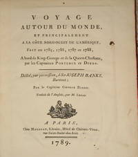
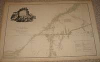
(22 maps & plates- Canada, Northwest American Coast Exploration): Voyage Autour Du Monde..A La Cote Nord-Ouest De L'Amerique..1785, 1786, 1787, 1788..Par Le Capitaines Portlock et Dixon
by Dixon, Capitaines George (dedicated to Sir Joseph Banks)
- Used
- very good
- Hardcover
- first
- Condition
- Used - Very Good
- Edition
- First Edition Thus
- Binding
- Hardcover
- Seller
-
Crozet, Virginia
- Item Price
-
$1,875.00$8.50 shipping to USA
Show Details
Item Price
$1,875.00
$8.50
shipping to USA
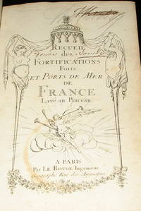
(Atlas, Military Forts- 89 plans): Recueil Des Fortifications Forts et Ports De Mer De France lave Au Pinceau
by Le Rouge, George Louis
- Used
- Hardcover
- Condition
- Used
- Binding
- Hardcover
- Seller
-
Crozet, Virginia
- Item Price
-
$1,200.00$8.50 shipping to USA
Show Details
Item Price
$1,200.00
$8.50
shipping to USA
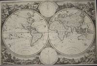
(World Map from Keur bible): Wereldkaart
by Jagen, Jan Van
- Used
- very good
- Condition
- Used - Very Good
- Seller
-
Crozet, Virginia
- Item Price
-
$2,950.00$8.50 shipping to USA
Show Details
Item Price
$2,950.00
$8.50
shipping to USA
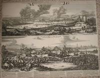
(2 Views; Second Anglo-Dutch War): Afbeeldingh van de stadt en revier van Rochester, Chetham..Aerdigh na 't leven geteeckent door W. Schellinks..zuydt-west syde, waer in klaer Vertoont..victorieuse uytwerckingh van de oorlochs vloot der ... Iunii 1667
by Schellinks, Willem and Hooghe, Romeyn De
- Used
- first
- Condition
- Used
- Edition
- First Edition Thus
- Seller
-
Crozet, Virginia
- Item Price
-
$1,950.00$8.50 shipping to USA
Show Details
Item Price
$1,950.00
$8.50
shipping to USA
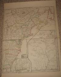
(Revolutionary War Era): A map of the inhabited part of Canada from the French surveys; wiith the frontiers of New York and New England from the large surveys
by Sauthier, Claude Joseph
- Used
- very good
- first
- Condition
- Used - Very Good
- Edition
- First Edition Thus
- Seller
-
Crozet, Virginia
- Item Price
-
$3,800.00$8.50 shipping to USA
Show Details
Item Price
$3,800.00
$8.50
shipping to USA
(Map, Revolutionary War Era, Colonial America): Theatre de la Guerre en Amerique
by Le Rouge, George Louis
- Used
- very good
- Condition
- Used - Very Good
- Seller
-
Crozet, Virginia
- Item Price
-
$3,600.00$8.50 shipping to USA
Show Details
Item Price
$3,600.00
$8.50
shipping to USA
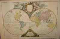
(Word Map): Orbis vetus in utrâque continente juxta mentem Sansonianam distinctus, nec non observationibus astronomicis redactus, accurante
by Robert de Vaugondy, Didier; Robert de Vaugondy, Gilles
- Used
- Condition
- Used
- Seller
-
Crozet, Virginia
- Item Price
-
$1,895.00$8.50 shipping to USA
Show Details
Item Price
$1,895.00
$8.50
shipping to USA
